Bourg-Saint-Maurice
| Bourg-Saint-Maurice | ||
|---|---|---|
|
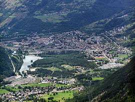
A general view of Bourg-Saint-Maurice | ||
| ||
 Bourg-Saint-Maurice | ||
|
Location within Auvergne-Rhône-Alpes region  Bourg-Saint-Maurice | ||
| Coordinates: 45°37′03″N 6°46′10″E / 45.6175°N 6.7694°ECoordinates: 45°37′03″N 6°46′10″E / 45.6175°N 6.7694°E | ||
| Country | France | |
| Region | Auvergne-Rhône-Alpes | |
| Department | Savoie | |
| Arrondissement | Albertville | |
| Canton | Bourg-Saint-Maurice | |
| Government | ||
| • Mayor (2011–2014) | Jacqueline Poletti | |
| Area1 | 179.07 km2 (69.14 sq mi) | |
| Population (2008)2 | 7,749 | |
| • Density | 43/km2 (110/sq mi) | |
| Time zone | CET (UTC+1) | |
| • Summer (DST) | CEST (UTC+2) | |
| INSEE/Postal code | 73054 / 73700 | |
| Elevation |
744–3,823 m (2,441–12,543 ft) (avg. 815 m or 2,674 ft) | |
|
1 French Land Register data, which excludes lakes, ponds, glaciers > 1 km² (0.386 sq mi or 247 acres) and river estuaries. 2 Population without double counting: residents of multiple communes (e.g., students and military personnel) only counted once. | ||
.svg.png)
Bourg-Saint-Maurice, popularly known as Bourg, is a commune in the Savoie department in the Auvergne-Rhône-Alpes region in south-eastern France.
It is the last large town along the Tarentaise valley in the heart of the French Alps.
History
Bergintrum was a place on the Gallic side of the pass of the Alpes Graiae, lying on the road marked in the Antonine Itinerary between Mediolanum (modern Milan) and Vienna (modern Vienne). D'Anville (Notice, etc.) places it, according to the Table, between Axima (modern Aime) and Alpis Graia. The distance from Bergintrum to Axima is marked viiii M. P. The Alpis Graia is usually identified with a settlement at the watershed on the pass of the Little Saint Bernard, which divides the waters that flow to the Isère on the French side from those that flow to the Dora Baltea on the Italian side. This is the place D'Anville calls l'Hôpital, on the authority of a manuscript map of the country. D'Anville first proposed the identification of Bergintrum with Bourg-Saint-Maurice; although he acknowledged that xii, the distance in the Table between Bergintrum and Alpis Graia, does not fit the distance between Bourg-Saint-Maurice and l'Hôpital, which is less. Modern scholarship confirms the identification.[1]
Outdoor activities

Bourg-Saint-Maurice is part of the Paradiski ski area (425 km of slopes, 141 lifts, 239 slopes - 12 Green, 132 Blue, 66 Red, 29 Black).[2] Although there is no skiing at this altitude, it is conveniently linked to Arc 1600 by the Arc en Ciel funicular railway and is therefore home to many budget rental properties. Unlike the villages that make up Les Arcs, Bourg-Saint-Maurice is open all year.
Bourg is also a popular summer destination, as it offers lots of opportunity for lovers of the outdoors and watersports. There is a whitewater slalom course on the Isere river used for international canoe and kayak competitions. The course on the Isere has been host to the ICF world championships and is used by many European teams as a training course in the summer. The course is often changed by the floods that occur during the winter months.
The surrounding mountains are good for walking and mountain biking. They also are a good place for paragliding and hang gliding. Some of Les Arcs ski lifts operate during July and August to get walkers to the higher peaks and you can take mountain bikes up on these. Mountain bikes (vélo tout terrain or VTT in French) can be hired in both Bourg and Les Arcs. Some of the high altitude restaurants open in these months, the ones at Pre st Esprit and L'Arpete have small outdoor pools.
The nearest summer glacier skiing is in Tignes (approximately 27 km from Bourg) on the Grande Motte; due to glacial recession, however, it is now closed at certain times of the year.
People
- The French ski mountaineer Bertrand Blanc was born in Bourg-Saint-Maurice on October 29, 1973.
See also
References
- ↑ Richard Talbert, Barrington Atlas of the Greek and Roman World, (ISBN 0-691-03169-X), Map 17.
- ↑ http://www.peakretreats.co.uk/winter/ski-resorts/paradiski/bourg-st-maurice
External links
| Wikimedia Commons has media related to Bourg-Saint-Maurice. |
- Official site municipality of Bourg Saint Maurice (French) (English)
- Webcams from Bourg Saint Maurice Les Arcs updated daily