Bosnia (region)
| Bosnia | |
|---|---|
| Region | |
|
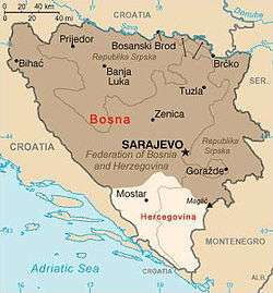
Approximate borders between two modern-day regions of Bosnia and Herzegovina - Bosnia (marked dark brown) and Herzegovina (marked light brown) | |
| Coordinates: 43°52′N 18°25′E / 43.867°N 18.417°ECoordinates: 43°52′N 18°25′E / 43.867°N 18.417°E | |
| Country | Bosnia and Herzegovina |
| Largest cities | Banja Luka |
| Area | |
| • Total | 41,000 km2 (16,000 sq mi) |
| Demonym(s) | Bosnian |
| Time zone | CET (UTC+1) |
| • Summer (DST) | CEST (UTC+2) |
Bosnia (Serbo-Croatian: Bosna/Босна; pronounced [bɔ̂sna]) is the northern region of Bosnia and Herzegovina, encompassing roughly 80% of the country; the other eponymous region, the southern part, is Herzegovina. Bosnia is an informal term for the whole country.
The two regions have formed a geopolitical entity since medieval times, and the name "Bosnia" commonly occurs in historical and geopolitical senses as generally referring to both regions (Bosnia and Herzegovina). The official use of the combined name started only in the late period of Ottoman-rule.
Geography
Bosnia lies mainly in the Dinaric Alps, ranging to the southern borders of the Pannonian plain, with the rivers Sava and Drina marking its northern and eastern borders.
The area of Bosnia comprises approximately 41,000 km2, and makes up about 80% of the territory of the present-day state of Bosnia and Herzegovina. There are no true borders between the region of Bosnia and the region of Herzegovina. Unofficially, Herzegovina is south of the mountain Ivan planina. According to another unofficial definition, Herzegovina encompasses watersheds Neretva and Trebišnjica rivers.
History
The historical records of the region are scarce until its first recorded standalone (domestic) ruler and viceroy of Bosnian state, Ban Borić, appointed by 1154.
De Administrando Imperio describes a small župa of Bosona (Greek: χωρίον Βόσονα) that was located around the river Bosna in the modern-day fields of Sarajevo and of Visoko.[1][2] The area is thought to have been previously inhabited by the Illyrian tribe of the Daesitiates.[3]
Under its first known foreign ruler, Stephen, Duke of Bosnia, in the 1080s, the region spanned the upper course of the rivers Bosna, the Vrbas and the Neretva.
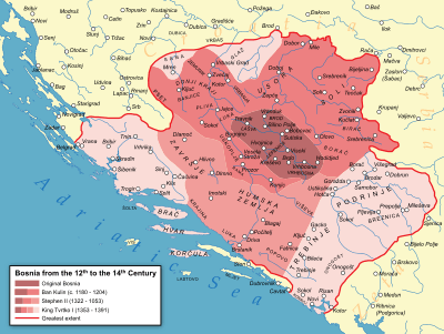
At the end of the 14th century, under Tvrtko I of Bosnia, the Bosnian kingdom included most of the territory of today's Bosnia and of what would later become known as Herzegovina.
The kingdom lost its independence to the Ottoman Empire in 1463. The region of Bosnia's westernmost city at the time of the conquest was Jajce.[4]
The Ottoman Empire initially expanded into Bosnia and Herzegovina through a territory called the Bosansko Krajište. It was transformed into the Sanjak of Bosnia and the Sanjak of Herzegovina after 1462/1463. The first Ottoman administration called Eyalet of Bosnia was finally formed in 1527, after long armed resistance to the north and to the west by Counts Franjo and Ivaniš Berislavić of the noble house of Berislavići Grabarski.
Eventually, following the Great Turkish War, in the 18th century the Eyalet came to encompass the area largely matching that of today's Bosnia and Herzegovina.
In 1833, the Eyalet of Herzegovina was temporarily split off under Ali-paša Rizvanbegović. The area acquired the name of "Bosnia and Herzegovina" in 1853 as a result of a twist in political events following his death. After the 1864 administrative reform, the province was named Vilayet of Bosnia. Austria-Hungary occupied the whole country in 1878. It remained formally part of the Ottoman Empire under the title of Condominium of Bosnia and Herzegovina until 1908, when Austria-Hungary provoked the Bosnian crisis formally annexing it.
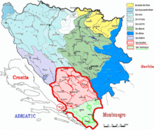
Subregions
- Bosanska Krajina, western
- Birač, eastern
- Posavina, northernmost
- Semberija, northeastern
Gallery
-
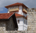
Gradačac - City castle
-
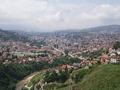
Sarajevo - View from east.
-
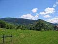
Mountains in Bosnia
-
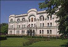
Banski dvor in Banja Luka
-
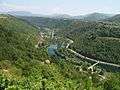
Una River - (view from Brekovica)
See also
References
- ↑ Vladimir Ćorović, Teritorijalni razvoj bosanske države u srednjem vijeku, Glas SKA 167, Belgrade, 1935, pp. 10-13
- ↑ "Rethinking the territorial development of the medieval Bosnian state". Historical Review. Serbian Academy of Sciences and Arts - Institute of History. LI: 52–53. 2004. ISSN 0350-0802. Retrieved 2012-09-12.
- ↑ Ivan Mužić (December 2010). "Bijeli Hrvati u banskoj Hrvatskoj i županijska Hrvatska". Starohrvatska prosvjeta (in Croatian). Split, Croatia: Museum of Croatian Archaeological Monuments. III (37): 270. ISSN 0351-4536. Retrieved 2012-09-12.
Bosna u obujmu, u kakvom se navodi u djelu DAI kao jedinstvena teritorijalna jedinica, protezala se, kako neki autori smatraju, na području u kojem su prije prebivali Desitijati (M. Hadžijahić). Ti Desitijati, koji su nastavali istočnu i srednju Bosnu počevši od Travnika prema Rogatici pa dalje, imali su središte oko današnje Breze. (Mandić 1942, str. 133.)
- ↑ Pinson, Mark (1996) [1993]. The Muslims of Bosnia-Herzegovina, the Historic Development from Middle Ages to the Dissolution of Yugoslavia (Second ed.). United States of America: President and Fellows of Harvard College. p. 11. ISBN 0-932885-12-8. Retrieved 2012-05-06.
[...] in Bosnia Jajce under Hungarian garrison actually held until 1527
External links
| Geographical |  | |
|---|---|---|
| Historical | ||