Boroughs and quarters of Hamburg
 |
| This article is part of a series on the politics and government of Hamburg |
|
Constitution |
|
Judiciary
|
|
Executive |
|
Divisions |
|
Elections |
|
Relations |
The city of Hamburg in Germany is made up of 7 boroughs (German: Bezirke, also known as districts or administrative districts) and subdivided into 104 quarters (German: Stadtteile). Most of the quarters were former independent settlements. As of 2008 the areal organisation is regulated by the constitution of Hamburg and several laws.
History
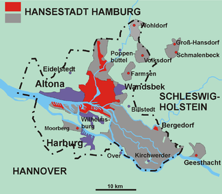
red: State of Hamburg 1815-1937
violet: Prussian cities like Altona
grey: new localities 1937
dotted line: Hamburg 2005
The first official administrative divisions of Hamburg were the parishes of four churches, the St. Peter's, St. Catherine's, St. James's and St. Nicholas's (or their preceding buildings). On February 24, 1529 a compromise of 132 articles between the senate of Hamburg and the citizens (German: Langer Rezeß) established a council of citizens. The 12 councilmen were called Oberalte (Eldermen) and were the 3 oldest diacons of the parishes. Each parish was given a confirmed border.[1]
1871
In 1871 at the declaration of the German Reich the State of Hamburg consists of the city of Hamburg with Altstadt (Old city), Neustadt (New city) and St. Georg (Hamburg since 1868). A suburb called St. Pauli and several directly named outskirts and the other land.
In the north former parts of the Province of Schleswig-Holstein with its municipalities Rotherbaum, Harvestehude, Eimsbüttel, Eppendorf, Winterhude, Uhlenhorst, Barmbeck, Eilbeck, Hohenfelde, Borgfelde, Hamm, Horn, Billwärder-Ausschlag, Steinwärder mit Grevenhof and the Kleiner Grasbrook. Rural areas have been e.g. Großborstel, Fuhlsbüttel, Langenhorn, Alsterdorf, Ohlsdorf, Kleinborstel, Struckholt. Localities named as Walddörfer (forest villages) Farmsen with Berne, Volksdorf, Wohldorf and Olstedt, Groß-Hansdorf and Schmalenbeck.[lower-alpha 1]
In the south rural areas between Bille and Elbe are located Billwärder an der Bille, Moorfleeth, Allermöhe, Spadenland, Tatenberg, Ochsenwärder and Reitbrook.[lower-alpha 1]
Several villages and rural areas are located south of river Elbe, e.g. Moorwärder, Kaltenhofe, Peute, Die große Veddel, Die kleine Veddel, Niedernfelde, Klütjenfelde, Ellerholz, Ross, Waltershof, Mühlenwärder, Dradenau and the municipalities Finkenwärder and Moorburg.[lower-alpha 1]
The city of Bergedorf and municipalities Curslak, Altengamme, Neuengamme, Kirchwärder, Krauel and Geesthacht. And the municipalities Cuxhaven, Groden, Döse, Süderwisch und Westerwisch, Stickenbüttel, Sahlenburg, Duhnen, Holte and Spangen, Arensch und Berensch, Oxstedt, Gudendorf and the island Neuwerk.[lower-alpha 1]
The Greater Hamburg Act
At April 1, 1938 due to the Gesetz über Groß-Hamburg und andere Gebietsbereinigungen (Greater Hamburg Act) (from January 26, 1937) the State Hamburg lost all its rural areas, they became part of the state of Hamburg. The city also gained considerable area from the province of Schleswig-Holstein as Altona and Wandsbek both became administrative districts of Hamburg. Furthermore, rural districts Bergstedt, Billstedt, Bramstedt, Bramfeld, Duvenstedt, Hummelsbüttel, Lemsahl-Mellingstedt, Lohbrügge, Poppenbüttel, Rahlstedt, Sasel, Steilshoop und Wellingsbüttel, Kurslack im Achterschlag, Lokstedt were added to the state's area. The Province of Hanover handed over the city district of Harburg-Wilhelmsburg. The settlements of the rural districts Altenwerder, Cranz, Finkenwerder, Fischbek, Francop, Gut Moor, Hannöversch Kirchwerder, Langenbek, Marmstorf, Neuenfelde, Neugraben, Neuland, Rönneburg, Sinstorf and parts of Over therefore became quarters within the state's borders.[lower-alpha 1]
Hamburg lost Cuxhaven, Geesthacht, Schmalenbeck, Groß Hansdorf and the isles of Neuwerk, Scharnhörn and Niegehörn.[lower-alpha 1]
1945 and later
In 1969 the isles were handed back to Hamburg and administered from the borough of Hamburg-Mitte ever since.
March 1, 2008 the quarter Wilhelmsburg became part of the borough Hamburg-Mitte. The neighbourhood Schanzenviertel in the boroughs Altona, Eimsbüttel and Hamburg-Mitte became the quarter Sternschanze in the borough Altona. The neighborhood HafenCity was awarded the status of a quarter.[2]
Boroughs

A borough of Hamburg is comparable to the third-level administration in Germany. In the Constitution of Hamburg it is determined that an area could be created by law for administrative purposes.[3] The boroughs were created with a law.[4] A borough has minor rights to establish laws and regulations compared to the districts of the states of Germany, because Hamburg is both a state and a city of Germany.
| Borough | Population | Area (km²) | Density |
|---|---|---|---|
| Hamburg-Mitte | 233,114[5] | 107.1 km² | 2,177 |
| Altona | 243,972[5] | 78.3 km² | 3,149 |
| Eimsbüttel | 246,087[5] | 50.1 km² | 4,915 |
| Hamburg-Nord | 279,498[5] | 57.8 km² | 4,838 |
| Wandsbek | 409,771[5] | 147.5 km² | 2,777 |
| Bergedorf | 118,942[5] | 154.8 km² | 769 |
| Harburg | 201,119[5] | 161.0 km² | 1,253 |
Diet of the borough
All boroughs of Hamburg have their own local parliament (German: Bezirksversammlung). The members of the Bezirksversammlung are elected alongside elections to Hamburg's state parliament (German: Hamburgische Bürgerschaft). It consists of 45, 51 or 57 representatives, depending on the population of the borough. The representatives are elected every four years under a system of proportional representation. The diet is a unicameral parliament and the representatives are elected in universal, direct, free, equal and secret elections. Every citizen of the European Union is entitled to vote, if on the day of election, they are 18 years old or more, and have registered their residency in Hamburg at least three months before and the citizen is not excluded from the right of vote.
The rights of the diet are mostly to be heard in questions of local importance (e.g. the location of fire brigade stations, schools etc.), to be informed by the main local office (Bezirksamt) but can also make compulsory resolutions to the main local office.
Municipal councillor
The administrative leader af a borough is called Bezirksamtsleiter (Meaning municipal councillor) and is elected by the Diet of the borough and thereafter his admission needs to get appointed by the Senat, Hamburgs's state cabinet.[4] Each borough is made up of several quarters.
Quarters
The quarters of Hamburg are not politically independent, but have officially recognised borders.[2] They have no self-government or administration. Most quarters have a history as an independent rural, urban or suburban locality and they form the basis of the state and city of Hamburg. This history is often shown in the endings of the name like Bergedorf. -dorf means village, so Bergedorf is the village in the mountains (Berg is German for mountain). Some quarters are made up of several official recognised locations, not to be confused with by inhabitants so called neighbourhoods. In total Hamburg is subdivided into 181 localities (German: Ortsteile).[6] St. Pauli quarter is much larger than the neighbourhood St. Pauli or Kiez which means the area around the Reeperbahn.
Areal organisation
Altona borough consists of the quarters Altona-Altstadt, Altona-Nord, Bahrenfeld, Blankenese, Groß Flottbek, Iserbrook, Lurup, Nienstedten, Osdorf, Othmarschen, Ottensen, Rissen, Sternschanze and Sülldorf.
The quarters Allermöhe, Altengamme, Bergedorf, Billwerder, Curslack, Kirchwerder, Lohbrügge, Moorfleet, Neuallermöhe, Neuengamme, Ochsenwerder, Reitbrook, Spadenland and Tatenberg belong to the Bergedorf borough.
The quarters Billbrook, Billstedt, Borgfelde, Finkenwerder, HafenCity, Hamburg-Altstadt, Hamm, Hammerbrook, Horn, Kleiner Grasbrook, Neustadt, Neuwerk, Rothenburgsort, Steinwerder, St. Georg, St. Pauli, Veddel, Waltershof and Wilhelmsburg belong to the borough Hamburg-Mitte.
Hamburg-Nord borough is made up of the quarters Alsterdorf, Barmbek-Nord, Barmbek-Süd, Dulsberg, Eppendorf, Fuhlsbüttel, Groß Borstel, Hoheluft-Ost, Hohenfelde, Langenhorn, Ohlsdorf, Uhlenhorst and Winterhude.
Altenwerder, Cranz, Eißendorf, Francop, Gut Moor, Harburg, Hausbruch, Heimfeld, Langenbek, Marmstorf, Moorburg, Neuenfelde, Neugraben-Fischbek, Neuland, Rönneburg, Sinstorf and Wilstorf are quarters in the borough of Harburg.
The Wandsbek borough consists of Bergstedt, Bramfeld, Duvenstedt, Eilbek, Farmsen-Berne, Hummelsbüttel, Jenfeld, Lemsahl-Mellingstedt, Marienthal, Poppenbüttel, Rahlstedt, Sasel, Steilshoop, Tonndorf, Volksdorf, Wandsbek, Wellingsbüttel and Wohldorf-Ohlstedt.
Eimsbüttel is split into nine quarters: Eidelstedt, Eimsbüttel, Harvestehude, Hoheluft-West, Lokstedt, Niendorf, Rotherbaum, Schnelsen and Stellingen.
For statistical purpose the borough Hamburg-Mitte has the group/area called Schiffsbevölkerung (people living on ships).[7]
In alphabetical order
- Allermöhe
- Alsterdorf
- Altengamme
- Altenwerder
- Altona-Altstadt
- Altona-Nord
- Bahrenfeld
- Barmbek-Nord
- Barmbek-Süd
- Bergedorf
- Bergstedt
- Billbrook
- Billwerder
- Billstedt
- Blankenese
- Borgfelde
- Bramfeld
- Cranz
- Curslack
- Dulsberg
- Duvenstedt
- Eidelstedt
- Eilbek
- Eimsbüttel
- Eißendorf
- Eppendorf
- Farmsen-Berne
- Finkenwerder
- Francop
- Fuhlsbüttel
- Groß Borstel
- Groß Flottbek
- Gut Moor
- HafenCity
- Hamburg-Altstadt
- Hamm
- Hammerbrook
- Harburg
- Harvestehude
- Hausbruch
- Heimfeld
- Hoheluft-Ost
- Hoheluft-West
- Hohenfelde
- Horn
- Hummelsbüttel
- Iserbrook
- Jenfeld
- Kirchwerder
- Kleiner Grasbrook
- Langenbek
- Langenhorn
- Lemsahl-Mellingstedt
- Lohbrügge
- Lokstedt
- Lurup
- Marienthal
- Marmstorf
- Moorburg
- Moorfleet
- Neuallermöhe
- Neuenfelde
- Neuengamme
- Neugraben-Fischbek
- Neuland
- Neustadt
- Neuwerk
- Niendorf
- Nienstedten
- Ochsenwerder
- Ohlsdorf
- Osdorf
- Othmarschen
- Ottensen
- Poppenbüttel
- Rahlstedt
- Reitbrook
- Rissen
- Rönneburg
- Rothenburgsort
- Rotherbaum
- Sasel
- Schnelsen
- Sinstorf
- Spadenland
- St. Georg
- St. Pauli
- Steilshoop
- Steinwerder
- Stellingen
- Sternschanze
- Sülldorf
- Tatenberg
- Tonndorf
- Uhlenhorst
- Veddel
- Volksdorf
- Wandsbek
- Waltershof
- Wellingsbüttel
- Wilhelmsburg
- Wilstorf
- Winterhude
- Wohldorf-Ohlstedt
Notes
See also
References
- ↑ Verg, Erich; Verg, Martin (2007), Das Abenteuer das Hamburg heißt (in German) (4th ed.), Hamburg: Ellert&Richter, pp. 45–46, ISBN 978-3-8319-0137-1
- 1 2 Act of the areal organisation
- ↑ Constitution of Hamburg, Art. 4
- 1 2 Bezirksverwaltungsgesetz (BezVG)
- 1 2 3 4 5 6 7 Residents registration office, source: statistical office Nord of Hamburg and Schleswig-Holstein (31.12.2006)
- ↑ List of streets and localities in Hamburg, p. 8
- ↑ Statistisches Jahrbuch Hamburg 2007/2008 ISSN 1614-8045 (German)
- General
- Constitution of Hamburg from 6 June 1952, last change 16 May 2001 Verfassung der Freien und Hansestadt Hamburg (German)
- Borough administration act Bezirksverwaltungsgesetz (BezVG) (German)
- Act of the areal organisation, July 6, 2006 Gesetz über die räumliche Gliederung der Freien und Hansestadt Hamburg (RäumGiG) (German)
- Streets and localities in Hamburg Straßen- und Gebietsverzeichnis der Freien und Hansestadt Hamburg 2008, Statistical office Hamburg and Schleswig-Holstein Statistisches Amt für Hamburg und Schleswig-Holstein, Hamburg, Germany (ISSN 0938-636X)
Parts translated from de:Bezirke in Hamburg
External links
![]() Media related to Subdivisions of Hamburg at Wikimedia Commons
Media related to Subdivisions of Hamburg at Wikimedia Commons
![]() Media related to Districts of Hamburg at Wikimedia Commons
Media related to Districts of Hamburg at Wikimedia Commons
![]() Media related to Quarters of Hamburg at Wikimedia Commons
Media related to Quarters of Hamburg at Wikimedia Commons
Freie und Hansestadt Hamburg | |
| Government and Symbols | |
| History and Culture | |
| Economy and Transport | |
Coordinates: 53°35′00″N 9°59′00″E / 53.58333°N 9.98333°E