Borough of Darlington
| Borough of Darlington | ||
|---|---|---|
| Unitary, Borough | ||
| ||
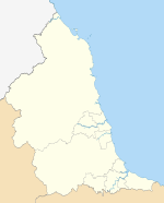
 Darlington shown within County Durham and England | ||
| Sovereign state | United Kingdom | |
| Constituent country | England | |
| Region | North East England | |
| Ceremonial county | County Durham | |
| Admin. HQ | Darlington | |
| Government | ||
| • Type | Darlington Borough Council | |
| • Leadership: | Leader & Cabinet | |
| • Executive: | Labour | |
| • MPs: |
Phil Wilson (L) Jenny Chapman (L) | |
| Area | ||
| • Total | 76.3 sq mi (197.5 km2) | |
| Area rank | 166th | |
| Population (mid-2014 est.) | ||
| • Total | 105,367 | |
| • Rank | Ranked 222nd | |
| • Density | 1,400/sq mi (530/km2) | |
| Time zone | Greenwich Mean Time (UTC+0) | |
| • Summer (DST) | British Summer Time (UTC+1) | |
| ONS code |
00EH (ONS) E06000005 (GSS) | |
| Ethnicity | 93.7% White, 2.8% S.Asian, 3.5% other Non-White | |
| Website | darlington.gov.uk | |

Darlington is a unitary authority area in the ceremonial county of County Durham, north-east England. It borders the non-metropolitan county of County Durham to the north and west, Stockton-on-Tees to the east and North Yorkshire to the south along the line of the River Tees. The urban centre of the borough is the town of Darlington and is a major component of the Tees Valley economic area. In 2011 it had a resident population of 106,000.
Council
Traditionally part of County Durham, the current borough boundaries were formed on 1 April 1974 by the creation of a new non-metropolitan district of Darlington by the Local Government Act 1972, covering the previous county borough of Darlington along with nearly all of Darlington Rural District (the Newton Aycliffe parts of which went to Sedgefield). It remained part of County Durham until gaining "independence" as a unitary authority on 1 April 1997. For ceremonial purposes it remains part of County Durham with whom it continues to share certain local services such as Fire and Rescue and Police. It is included within the Tees Valley area for both cultural and regional government administration.
It is made up of 24 council wards, twenty within the town of Darlington itself, which are also covered by the Darlington parliamentary constituency and four rural wards of Heighington & Coniscliffe, Hurworth, Middleton St George and Sadberge & Whessoe (part of the Sedgefield parliamentary constituency.
As well as Darlington itself the borough includes the surrounding villages of:
- Archdeacon Newton
- Barmpton
- Beaumont Hill
- Bishopton
- Blackwell
- Brafferton
- Coatham Mundeville
- Denton
- Great Burdon
- Great Stainton
- Heighington
- High Coniscliffe
- Houghton Bank
- Houghton-le-Side
- Hurworth-on-Tees
- Hurworth Place
- Killerby
- Little Stainton
- Low Dinsdale
- Middleton One Row
- Middleton St George
- Neasham
- Oak Tree
- Piercebridge
- Redworth
- Sadberge
- Summerhouse
- Walworth Gate
- Walworth
It is also home to Durham Tees Valley Airport (previously known as Teesside International Airport), of which the borough council shares joint ownership with the other four Tees Valley councils and Peel Holdings.
The council operates a Leader and Cabinet model of political leadership although a group of local residents aimed to force a referendum on moving to a system with directly-elected executive Mayor.[1] Their bid was unsuccessful.
The political composition of the council, as of a May 2011 local elections, is Labour 34; Conservative 14; Liberal Democrats 5.[2]
| Party | Seats[2][3] | Current council | |||||||||||||||||||||||||||||||||||
|---|---|---|---|---|---|---|---|---|---|---|---|---|---|---|---|---|---|---|---|---|---|---|---|---|---|---|---|---|---|---|---|---|---|---|---|---|---|
| Labour | 34 | ||||||||||||||||||||||||||||||||||||
| Conservative | 14 | ||||||||||||||||||||||||||||||||||||
| Lib Dems | 5 | ||||||||||||||||||||||||||||||||||||
Economy
This is a chart of trend of regional gross value added of Darlington at current basic prices published (pp. 240–253) by Office for National Statistics with figures in millions of British Pounds Sterling.
| Year | Regional Gross Value Added4 | Agriculture1 | Industry2 | Services3 |
|---|---|---|---|---|
| 1995 | 1,115 | 8 | 377 | 729 |
| 2000 | 1,192 | 6 | 417 | 768 |
| 2003 | 1,538 | 6 | 561 | 971 |
^1 includes hunting and forestry
^2 includes energy and construction
^3 includes financial intermediation services indirectly measured
^4 Components may not sum to totals due to rounding
References
- ↑ "Pro-mayor group halfway to securing a referendum". The Northern Echo. 29 August 2006. Retrieved 29 August 2007.
- 1 2 "Local Election Results 2011 Summary". Association of Liberal Democrat Councillors. Retrieved 22 July 2011.
- ↑ "North Road by-election results". Darlington Borough Council. Retrieved 30 December 2009.
External links
- Darlington Borough Council
- Darlington Tourist Information
- Darlington Railway Centre & Museum
- Darlington Arts Centre & Civic Theatre
Video clips
North East England Portal | |
| Unitary authorities | |
| Major settlements |
|
| Topics | |
Coordinates: 54°31′00″N 1°33′00″W / 54.5167°N 1.5500°W