Bornheim (Frankfurt am Main)
| Bornheim | ||
|---|---|---|
| Stadtteil of Frankfurt am Main | ||
| ||
 Bornheim | ||
Location of Bornheim (red) and the Ortsbezirk Bornheim/Ostend (light red) within Frankfurt am Main 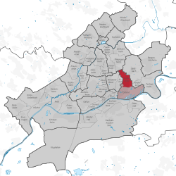 | ||
| Coordinates: 50°07′43″N 08°42′42″E / 50.12861°N 8.71167°ECoordinates: 50°07′43″N 08°42′42″E / 50.12861°N 8.71167°E | ||
| Country | Germany | |
| State | Hesse | |
| Admin. region | Darmstadt | |
| District | Urban district | |
| Town | Frankfurt am Main | |
| Area | ||
| • Total | 2.78 km2 (1.07 sq mi) | |
| Population (2007-12-31) | ||
| • Total | 26,332 | |
| • Density | 9,500/km2 (25,000/sq mi) | |
| Time zone | CET/CEST (UTC+1/+2) | |
| Postal codes | 60385, 60386, 60389 | |
| Dialling codes | 069 | |
| Vehicle registration | F | |

Bornheim is a city district of Frankfurt am Main, Germany. It is part of the Ortsbezirk Bornheim/Ostend.
In the past, Bornheim was called Das lustige Dorf ("The merry village"), because it was the red-light district of Frankfurt up to some 120 years ago. It still retains some of its lively charm and is said to be the younger crowd's hangout, shared with Sachsenhausen. The main street of Bornheim is Berger Straße, a cosmopolitan boulevard with many bars, pubs and restaurants and two of Frankfurt's most traditional cider houses, Solzer and Zur Sonne. The Holy Cross Church with the Centre for Christian Meditation and Spirituality of the Diocese of Limburg, known for its modernist architecture, is located in Bornheim.
Two underground lines (U4 and U7) run through Bornheim.
External links
| Wikimedia Commons has media related to Frankfurt-Bornheim. |