Borg á Mýrum

Borg á Mýrum is a farm and church estate due west of Borgarnes township in Iceland. Its recorded history reaches back to the settlement of Iceland. One of the country's original settlers was Skallagrímur Kveldúlfsson, who claimed the area around Borg as his land, built a farm and made his home there. His son Egill Skallagrímsson then continued to live and farm at Borg á Mýrum.
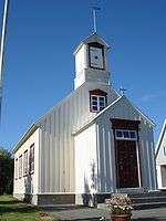
Borg á Mýrum has had a church ever since Iceland was Christianised around the year 1000, shortly after Egill's death. The present church at Borg was built in 1880, and is notable for its geographical alignment: it faces North-South, which is not traditional for Icelandic churches. It is also unusual in that the church building does not stand in the church yard, but is separated from it by the farm buildings.
The altarpiece, depicting Christ blessing the little children, is unique in Iceland for being painted in Pre-Raphaelite style. The artist was W.G. Collingwood, who visited Iceland in 1897.[1] Collingwood made an extensive trip around the country in preparation for an illustrated book he published on "saga-steads", the locations of the Icelandic Sagas.[2]
At Borg á Mýrum Collingwood found 'the historical homestead, still partly built of oak-beams carved and moulded in the ancient times'. This building has not survived,[3] but there is a twentieth-century monument to Egill by the sculptor Ásmundur Sveinsson. The abstract sculpture represents him as the poet of Sonatorrek in which he grieves for two of his sons, Gunnar and Böðvarr.
See also
References
- ↑ "Collingwood's Letters from Iceland". Cumberland and Westmorland Herald. 2014. Retrieved 8 February 2015.
- ↑ A Pilgrimage to the Saga-steads of Iceland. W.G.Collingwood, Jón Stefánsson (Holmes, Ulverston, 1899). (The National Museum of Iceland has a collection of his art work related to the book)
- ↑ "Egils saga in the past and present". 2010. Retrieved 11 February 2016.
Sources
- Þorsteinn Jósepsson, Steindór Steindórsson og Páll Líndal: Landið þitt Ísland, A-G, Örn og Örlygur, 1982.
- Björn Hróarsson: Á ferð um landið, Borgarfjörður og Mýrar, Mál og menning, 1994. ISBN 9979-3-0657-2
Coordinates: 64°33′41″N 21°54′55″W / 64.5615°N 21.9154°W