Bordj Badji Mokhtar
| Bordj Badji Mokhtar ﺑﺮج ﺑﺎﺟﻰ ﻣﺨﺘﺎر | |
|---|---|
| Town and commune | |
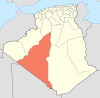
_location_map.svg.png) Location of Bordj Badji Mokhtar commune within Adrar Province | |
 Bordj Badji Mokhtar Location of Bordj Badji Mokhtar in Algeria | |
| Coordinates: 21°19′44″N 0°57′15″E / 21.32889°N 0.95417°ECoordinates: 21°19′44″N 0°57′15″E / 21.32889°N 0.95417°E | |
| Country | Algeria |
| Province | Adrar |
| District | Bordj Badji Mokhtar |
| Elevation | 401 m (1,316 ft) |
| Population (2008)[1] | |
| • Total | 16,437 |
| Time zone | CET (UTC+1) |
Bordj Badji Mokhtar (Arabic: برج باجي مختار) is a town and commune in Bordj Badji Mokhtar District, Adrar Province, in south-western Algeria. According to the 2008 census it has a population of 16,437,[1] up from 9,323 in 1998,[2] with an annual growth rate of 6.0%, the highest in the province.[1]
The Prime Meridian passes near Bordj Badji Mokhtar.
Geography
Bordj Badji Mokhtar is located at an elevation of 401 metres (1,316 ft) in the Tanezrouft, a desolate and mostly flat area in the Sahara Desert. The region is extremely sparsely populated with only four significant settlements in the Algerian part (the other three being Timiaouine, In Guezzam and Tin Zaouatine). Unlike most other towns in Saharan Algeria, Bordj Badji Mokhtar is not settled near an oasis but water is available from wells dug 400 metres (1,300 ft) underground.[3]
Climate
Bordj Badji Mokhtar has a hot desert climate (Köppen climate classification BWh), with long, extremely hot summers and short but hot winters, and very little rainfall throughout the year as the town only averages 38 mm (1.5 in) of rainfall. Occasional showers and thunderstorms do occur from July to September due as the town falls under the far northern edge of influence of the West African Monsoon.
| Climate data for Bordj Badji Mokhtar | |||||||||||||
|---|---|---|---|---|---|---|---|---|---|---|---|---|---|
| Month | Jan | Feb | Mar | Apr | May | Jun | Jul | Aug | Sep | Oct | Nov | Dec | Year |
| Average high °C (°F) | 26.0 (78.8) |
29.3 (84.7) |
32.7 (90.9) |
37.0 (98.6) |
40.4 (104.7) |
43.5 (110.3) |
42.9 (109.2) |
41.9 (107.4) |
41.0 (105.8) |
37.1 (98.8) |
31.5 (88.7) |
27.1 (80.8) |
35.87 (96.56) |
| Daily mean °C (°F) | 18.7 (65.7) |
21.4 (70.5) |
24.7 (76.5) |
28.8 (83.8) |
32.6 (90.7) |
36.0 (96.8) |
35.6 (96.1) |
34.8 (94.6) |
33.8 (92.8) |
29.8 (85.6) |
24.2 (75.6) |
19.9 (67.8) |
28.36 (83.04) |
| Average low °C (°F) | 11.4 (52.5) |
13.6 (56.5) |
16.8 (62.2) |
20.7 (69.3) |
24.8 (76.6) |
28.6 (83.5) |
28.4 (83.1) |
27.8 (82) |
26.6 (79.9) |
22.6 (72.7) |
17.0 (62.6) |
12.7 (54.9) |
20.92 (69.65) |
| Average precipitation mm (inches) | 1.1 (0.043) |
0 (0) |
0 (0) |
0 (0) |
0.9 (0.035) |
2.2 (0.087) |
5.8 (0.228) |
15.9 (0.626) |
10.1 (0.398) |
2 (0.08) |
0 (0) |
0 (0) |
38 (1.497) |
| Source: climate-data.org[4] | |||||||||||||
Transportation
Bordj Badji Mokhtar is very distant from other population centres, but the N6 national highway does connect it to Reggane and Adrar to the north and Timiaouine to the southeast. There is a border crossing into Mali about 20 kilometres (12 mi) southeast of the town.
Bordj Badji Mokhtar is served by Bordj Badji Mokhtar Airport.[5]
Education
1.2% of the population has a tertiary education, and another 4.4% has completed secondary education.[6] The overall literacy rate is 26.1% (the lowest for any commune in Adrar Province), and is 33.3% among males (the lowest in the province) and 17.8% among females (the second lowest in the province).[7]
Localities
As of 1984, the commune was composed of one locality:[8]
- Bordj Badji Mokhtar
References
- 1 2 3 "Population: Wilaya d'Adrar" (PDF) (in French). Office National des Statistiques Algérie. Archived from the original (PDF) on 16 December 2011. Retrieved 1 July 2013.
- ↑ "Algeria Communes". Statoids. Retrieved 8 March 2013.
- ↑ El Hachemi (8 August 2006). "A la découverte de Bordj-Badji Mokhtar et Timiaouine dans le grand Tanezrouf" (in French). DjaZairess. Retrieved 31 July 2013.
Ici à BBM, l'eau, source de vie est difficile d'accès et pour aller la chercher, il faut des forages qui dépassent largement les 400 mètres.
- ↑ "Climate data for: Bordj Badji Mokhtar". climate-data.org. Retrieved 31 July 2013.
- ↑ "Bordj Badji Mokhtar Airport". OurAirports. Retrieved 31 July 2013.
- ↑ "Structure relative de la population résidente des ménages ordinaires et collectifs âgée de 6 ans et plus selon le niveau d'instruction et la commune de résidence." (PDF) (in French). Office National des Statistiques Algérie. Archived from the original (PDF) on 13 November 2011. Retrieved 1 July 2013.
- ↑ "Taux d'analphabétisme et taux d'alphabétisation de la population âgée de 15 ans et plus, selon le sexe et la commune de résidence ." (PDF) (in French). Office National des Statistiques Algérie. Archived from the original (PDF) on 13 November 2011. Retrieved 1 July 2013.
- ↑ "Décret n° 84-365, fixant la composition, la consistance et les limites territoriale des communes. Wilaya d'Adrar" (PDF) (in French). Journal officiel de la République Algérienne,. 19 December 1984. p. 1472. Archived from the original (PDF) on 2 March 2013 or before. Retrieved 1 July 2013. Check date values in:
|archive-date=(help)
 |
Tindouf Chenachène (Tindouf) |
Adrar Reggane |
In Salah (Tamanrasset) | |
| Taoudenni (Mali) | |
Abalessa (Tamanrasset) Tamanrasset | ||
| ||||
| | ||||
| Timbuktu (Mali) | Tessalit (Mali) | Timiaouine |