Borden Peninsula
The Borden Peninsula[1] is a peninsula on northern Baffin Island, in Nunavut, Canada. It lies south of Lancaster Sound. Northeastern Borden Peninsula is home to Sirmilik National Park.
Geography
Borden Peninsula extends north for 225 km (140 mi). It is 64 km (40 mi) - 169 km (105 mi) wide.[1]
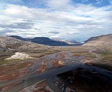
The northern area, including the Hartz Mountains, are composed of flat, dissected rock rising to over 914 m (2,999 ft) above sea level. The Magda Plateau is to the south where river valleys occupy the land, dividing scarps and flat-topped hills. Admiralty Inlet forms a western border, while Navy Board Inlet forms a border to the east, separating the peninsula from Bylot Island. Navy Board Inlet's coastal cliffs rise to 457 m (1,499 ft).[1] [2]
Population
The Inuit community of Arctic Bay is on the western coast.
Industry
The peninsula has seen mining activity for decades, especially for diamonds.[3]
References
- 1 2 3 "Borden Peninsula". The Columbia Gazetteer of North America. bartleby.com. 2000. Archived from the original on 2005-04-22. Retrieved 2008-09-22.
- ↑ "Baffin Island". uoguelph.ca. Retrieved 2008-09-22.
- ↑ Iwanaka, Derek (2008-08-25). "Committee Bay Resources Ltd.: Kimberlite Discovered at Borden Peninsula, Nunavut, Canada". finance.yahoo.com. Retrieved 2008-09-22.
- Borden Peninsula at the Atlas of Canada
External links
- "Aerial photo". Archived from the original on 2010-12-23. Retrieved 2009-03-14.
Coordinates: 72°59′59″N 083°00′00″W / 72.99972°N 83.00000°W