List of New Rochelle neighborhoods
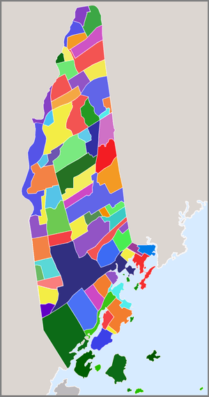

New Rochelle, New York occupies an area of roughly 10.5 square miles in Southern Westchester County, bounded on the south by Long Island Sound; on the west by Pelham Manor, Pelham and Eastchester; on the north by Scarsdale; and on the east by Scarsdale, Mamaroneck and Larchmont. For nearly two centuries from its settlement in 1688, New Rochelle was a quiet farming community with a bustling water dependent commercial center. Its proximity to the Sound had resulted in a booming resort trade by the late 1800s and wealthy Manhattanites flocked to the city's shores for recreation and relaxation. In 1889, The Town and Village of New Rochelle were incorporated as one city with a population of 14,000 residents. Just three decades later, New Rochelle's population had grown to over 54,000, having become one of the most sought after suburban communities in the country over 54,000. The community's expansion of infrastructure and neighborhoods kept pace with the mushrooming population. These early suburban neighborhoods were extremely popular with commuters, a new segment of American society choosing to live outside of the urban center and travel in daily for work. Developers immediately set to the task of providing them with fine homes and desirable communities on the waiting large tracts of farmland. Beginning with the southern tier of town, planned residential communities spread across the City, ultimately earning it the nickname "City of Homes".
The natural beauty and diverse geography of the area greatly influenced the primarily residential development of throughout most of the city, evidenced by the more than fifty 'residential parks' found today. Some of the country's most expensive residential real estate can be found in New Rochelle as well: The Wykagyl 10804 postal code covering much of the city's north end is ranked on Forbes magazine's annual '500 most expensive zip-codes' list, with an average household income of $199,061 and an average home price over $752,000. In the city's southern end, homes in the gated waterfront enclave Premium Point can cost anywhere from $2 to $20 million.
The Downtown and South End, in contrast, are quite densely populated, with many multi-family residential complexes and high rise apartment buildings. There are more than 11,500 single family units within the city, more than neighboring Larchmont, Mamaroneck and Scarsdale combined. The total number of households surpasses 26,000, more than that of neighboring Pelham, Pelham Manor, Eastchester, Scarsdale, Mamaroneck and Larchmont combined.
The city is served by zip-codes 10801, 10802, 10804, 10805 and 10583.
City
New Rochelle - maps: road • satellite • terrain
Zip-code areas
- Zip-code map
- 10804 - maps: road • satellite • terrain
- 10801 - maps: road • satellite • terrain
- 10805 - maps: road • satellite • terrain
- 10583 - maps: road • satellite • terrain
Primary and secondary areas


- Anchorage: waterfront enclave on Davenports Neck, along Titus Mill-Pond and Titus Mill-Pond State Tidal Wetlands.
- Bayberry Park: an upper-middle-class neighborhood of ranch, split-level and colonial style homes established in 1954. Located in the northern end of the city, the community originally attracted attention as the only new home colony in Westchester with its own recreation facilities including swimming pools, basketball courts, tennis courts, a playground and day camp, and a clubhouse. Sheldrake Lake, nature preserve and adjacent Goodliffe Pond border the community on the north while the Leatherstocking Nature Trail and woodlands border it on the east.[1][2][3][4]
- Beechmont: planned in 1902 by Eugene Lambden and his brother John for the City Realty Company.[5] The neighborhood is centered on Beechmont Lake, created in 1902[6] by damming Pine Brook. Beechmont lies on the eastern side of New Rochelle, bordering the town of Mamaroneck. Rochelle Heights is immediately to the south of Beechmont, while Forest Heights, Forest Knolls, and Paine Heights are to the north and Larchmont Woods and Forest Knolls are to the northeast. North Avenue forms the extreme western boundary.[7]
- Beechmont Gardens / Beechmont Knolls: subsections of Beechmont community east of Pinebrook Boulevard
- Beechmont Woods: eastern end of Beechmont adjacent to Larchmont Woods and Town of Mamaroneck.
- Bloomindaale Estates: upscale residential 1980s development on former private Bloomindaale estate.
- Bon Air Park: east of Wykagyl between North Avenue and the Nature Study-Twin Lakes preserve
- Bonnie Crest: located to the north of Wykagyl's business district.;[8] The area was first conceived in 1910 when "Upper Rochelle" was entirely farmland. The small hamlet of Cooper's Corner served as the satellite to the downtown area for farmers living in the area. The real estate group that purchased all of the farmland to create the neighborhood were motivated by the construction of the New York-Westchester-Boston Railroad line and creation of a Wykagyl station nearby for potential commuters. The railroad was responsible for the growth of Wykagyl, its business district, and many of the large residential parks in the area.(Main thoroughfares: Buell Drive, Decatur Terrace, Evans Road, Fairman Drive, Farragut Road, Fenimore Road, Graham Road, Mildred Parkway, Lovell Road)
- Chatsworth: middle-class residential neighborhood adjacent to the City Park athletic fields. The area of 'Chatsworth' originated along the Town of Mamaroneck, City of New Rochelle border half a mile to the east. It included land within both communities, including portions of what is now the eastern end of Beechmont as well as the southern part of Larchmont Woods.
- Chauncey Estates: older community north of the Downtown district between North Avenue and Webster Avenue. This area consists of older homes zoned from the early 1900s.
- Cherry Lawn: newest community to the City, planned around a central greenspace reminiscent of the classic 'town square' concept. The area was developed on the last remaining farmland in the city.
- Congress Park: (Congress Avenue)
- Cooper's Corner: For over two centuries Cooper's Corner served as an outpost for residents who lived in Upper New Rochelle miles from the downtown hub. The hamlet took shape at North Avenue and Mill Road near Burtis Mill that was powered by the Hutchinson River. It eventually included the general store of John Cooper, the 1795 Cooper's Corner School, the 1859 St. John's Wilmot Church, and the 1901 Wilmot Fire Station No. 6.
- Daisy Farms: 1950s residential development of single family homes in northern section of the city. The north end property was once the "Great", Daisy Farms, a working farm and equestrian estate ( home to the Hutchinson Riding Academy ), situated east of the old Wilmot Road leading to Scarsdale. The farm, owned by Adrian Iselin, Jr., became the centerpiece of the Adelin Property Corporation - hundreds of adjacent acres amassed by the millionaire in the 1920s in preparation for new development following the community's steady growth northward. This, however, did not happen for several decades due to the Great Depression and World War II. The Berne Construction Company of White Plains acquired the property in 1951 on which it constructed over 300 single family ranch style homes of spacious lots. A 12-acre parcel was acquired by the City for a North End School, the present day George M. Davis Elementary.
- Davenport Neck: historic waterfront peninsula originally inhabited by Siwanoy Indian tribes in the 1500s and 1600s. Over time the area became the summer vacation destination for wealthy New York families looking to retreat to impressive waterfront estates along Long Island Sound. Today the peninsula is home to a number of upscale residential communities and shore and yacht clubs.
- Dillon Park: (Boundary: Boston Post Road at Larchmont town line)
- Dorchester Hills: northernmost neighborhood in New Rochelle, bordered on the south by Wilmot Woods, the west by Scarsdale Downs and Scarsdale Park, and on the north and east by the Heathcote section of the Village of Scarsdale.
- East End: residential area bounded generally by U. S. I (Post Road) on the south, North Avenue on the west, the Town of Mamaroneck on the east, and Fifth Avenue and Palmer Avenue on the north. The southern section of this district is a middle-class neighborhood with properties dating from the early 1900s onward. It contains the City's only row houses, located on Stephenson Boulevard. Much of the area was originally owned by inventor John Stephenson and for some years early in the twentieth century was the home to workers involved with the Thanhouser Movie Studios nearby on Main Street.
- Echo Manor: waterfront community on the western edge of Echo Bay
- Edgewood Park: Located in the West End and Originally called "St. Luke Place", Edgewood park is a horseshoe shaped street off Lockwood avenue. This small neighborhood contains many Multi-family and single family houses. This street was the residence of former New Rochelle Councilman McNamara and is the currently home to Councilman Trangucci.
- Feeney Park: middle-class neighborhood located in the city's west end along the Pelham border.
- Fifth Avenue Park: Fifth Avenue
- Franklin Avenue: mixed residential/ commercial section Downtown, between Main Street on the north and Pelham Road on the south.
- French Ridge: located west of Downtown New Rochelle along the Pelham border. The neighborhood is currently up for review as a National Historic District.
- Forest Heights: (Boundary: North Avenue between Beechmont Road and Broadview Avenue). Development dates from the early twentieth century and includes the 1906 Broadview neighborhood. Most homes in this area date from the teens and 1920s. The area is characterized by estate-scale homes on large lots. Architectural styles prevalent within this area include Colonial Revival, English Tudor Revival and French Norman Revival.
- Forest Knolls: bordered by Beechmont on the south and Larchmont Woods on the west[9][10]
- Glenwood Lake: this area is bounded on the south by Lincoln Avenue, on the east by Webster Avenue, on the north by Eastchester Road, and on the west by Pelham. Glenwood Lake is a neighborhood of relatively small lots with modest houses built during the 1920s and after. Included within this area is the former Bergholtz Estate, which was sold to John Muir in the 1920s and was subsequently subdivided and built with homes built in the Colonial, Tudor and Mediterranean styles. Glenwood Lake is located near the Pelham line in the western portion of this area. Much of the activity of this area is centered on Webster School, a wonderful example of WPA' construction during the 1930s.
- Halcyon Park: (Boundary: North Avenue, Fifth Avenue)
- Hazelhurst Park: early 20th century residential park situated along the Larchmont/ New Rochelle border.
- Highland Park: a residential area located in the Wykagyl section of northern New Rochelle. The area is bordered by Wykagyl Crossways on the north, Interlaken on the west, Huguenot Park on the south, and Paine Heights on the east. The area is situated just north of the Mahlstedt family's ice lakes which operated at North Avenue and Eastchester Road through the early 1900s. The surrounding land remained as undeveloped meadows and farmland through the turn of the Twentieth Century when planning for Highland Park began. Maps from 1901 display sections of farmland crisscrossed by lines representing streets. Identified by British names such as Aberfoyle, Calton, Inverness, and Perth, the new roads were lined with spacious lots on which large single-family homes were built.
- Hillcrest: (Boundary: Fifth Avenue, Halcyon Park, Chatsworth)
- Hillandale: bordered by Pinebrook on the west, Cherry Lawn on the south and Scarsdale Village on the east.
- Home Park: (Boundary: Main Street, Harrison and Echo Avenue)
- Homestead Park: a residential area located in the southern portion of New Rochelle. The area is bordered by Residence Park on the west, Franklin Avenue on the east and Shore Road on the south and Downtown New Rochelle on the north.[11][12]
- Huguenot Heights
- Huguenot Park: early 20th century residential park (Boundary: Clinton Avenue and Pelham Line, Eastchester Road south to Lincoln Avenue) [13][14]
- Hutchinson Park: small community located at the city's northern tip along the Eastchester line. The area consists of homes built primarily during the late 1950s through the 1970s. The homes reflect the mid-20th century ranch style.
- Interlaken: residential park straddling the western edge of New Rochelle and Eastchester
- Kensington Woods: gated community in north-western section of the city adjacent to Bonnie Crest, Lake Isle and Eastchester. The area consists of modern colonial homes which range from 1 - 1.8 million dollars (as per 2012).
- Kress Park: historic, early 20th century residential park (Boundary: Webster Avenue from Lincoln Avenue to Kress Avenue inclusive)
- Lake Isle: located along the eastern side of the former reservoir 'Lake Isle', the community consists of lakefront homes and estates and continues into neighboring Eastchester as well.
- Lake Forest Park: (Boundary: Webster Avenue north of Eastchester Road)
- Larchmont Woods: this residential area is bounded by the Larchmont corporate limits on the east, Bayberry on the north, Forest Knolls on the west, and by Beechmont on the south. It consists of homes of varied scales, erected during the 1930s, 1940s, and 1950s, as older residential parks within the City were built out.
- Lyncroft: early 20th century residential park consisting of Tudor, Mediterranean and Colonial estate homes in a wooded setting. Lyncroft is adjacent to Paine Heights and Wykagyl Park.
- Maplewood: 1950s era residential development in the city's north end [15][16]
- Middletown: former hamlet of the Town of New Rochelle which covered portions of the community along North Avenue near Thomas Paine's Farm.
- Nautilus Park: (Nautilus Place)
- Neptune Park: (Neptune Avenue) close proximity to New Rochelle Harbor, on the heights overlooking the Sound.
- Northfield: small residential community located west of the Wykagyl business district.
- Northwood Knolls
- Paine Heights: 320 acres of land presented as a gift to Thomas Paine for his service in the American Revolution. Later became an early 20th century residential development of large homes along wide boulevards. The former home of American Revolutionary Tom Paine is located here.
- Pelhamwood: located long the Pelham border, this community has both a New Rochelle and Pelham section.
- Petersville: an early community which included the City Park properties and various neighboring commercial Zones.
- Pineridge: neighborhood located in northern end of the city adjacent to Ward Acres and Wykagyl. The area features large ranch-style homes constructed in the 1960s.
- Pinebrook: bordered by Ward Acres Reserve on the west, the area includes the subsections of Pinebrook Estates, Pinebrook Hollow and Brookridge.[17][18]
- Pinebrook Heights: the residential area north of Sheldrake Lake.[19][20]
- Premium Point: exclusive, gated community in the southeastern end of the city on Long Island Sound.[8][21][22] This area spans the border with the neighboring Village of Larchmont. The homes here range from 2 - 20 million dollars.[23][24]
- Premium Point Park: waterfront community on Echo Bay between the gated Premium Point community on the east and The Salesian High School campus and Five Islands Park on the west. The Premium Point Park Associate, founded in 1922, is a dues-paying association that provides and maintains upkeep on its common properties including park land along the shore, recreational space, and docks for waterfront access.
- Pryor Manor: located on the Pryer Marshes and Wetlands along the Larchmont Village border. The community is characterized by stately Tudor and mediterranean homes and winding roadways.[25]
- Quaker Hills
- Quaker Ridge: residential neighborhood located along the Scarsdale border.[26][27] The Quaker Ridge Improvement Company was organized for the development of the Quaker Ridge section of New Rochelle, backed by some of the wealthiest men in the Westchester real estate field. This development was the first one in the immediate "Quaker Ridge Station" area. The station constructed by the New York, Westchester & Boston Railway system was the nicest one on the entire line. The proximity to New York was a strong point of the station and the area, with commuters able to reach the southernmost point of Manhattan within fifty-three minutes or less. The Quaker Ridge property was seen as exceptionally well located for residential purposes. The property fronted on the Quaker Ridge Station, and intersected with wide, newly built drives and boulevards. A "trading section" set aside for the stores and shops at which residents were to shop, was also originally planned.
- Quaker Ridge Park
- Residence Park: historic residential park planned in the late 1880s [28] which also includes the main campus of the College of New Rochelle. (Boundary: Leland Avenue, Drake Avenue, Pelham Road, Main Street) [29]
- Rochelle Heights: established starting in 1905 on the former estate of George G. Sickles, a Wall Street financier. Plans were developed by New York City architects Mann, MacNellie and Lindeberg, including lots and homes in a wide range of sizes.[30] (Boundary: Fifth Avenue, Rochelle Park, North Avenue)
- Rochelle Park: (Boundary: North Avenue, Stephenson estate, Carpenter estate, Haskin estate (and others) and Sickles estate {3rd Ward})
- Rochelle Park-Rochelle Heights Historic District: spanning two neighborhoods, this district was listed on the U.S. National Register of Historic Places in 2005.[31]
- Rockland Park
- Rose Hill: 1930s residential park bordered by Highland Park on the south and Wykagyl Crossways on the north. Around the turn of the 20th century the area was the home of the Rose Hill Nurseries & Greenhouses, a world renown domesticator of orchids and cultivator of rare and exotic flowers and plants.
- Rosedale: 1950s era residential development situated in the northern end of the city, bordered by the Hutchinson River Parkway to the north and Bonnie Crest to the south.
- Rouken Glen: situated along the New Rochelle/ Mamaroneck Town border with portions in both communities
- Sans Souci: named for the former Davenport family estate on which it was built, this waterfront community overlooks New Rochelle Harbor and Long Island Sound [32][33]
- Scarsdale Downs: situated at the northernmost end of the city along the Scarsdale Town border.[34][35]
- Scarsdale Park: situated at the northernmost end of the city along the Scarsdale Town border.[36][37]
- Sheldrake Heights
- Spencer Park: bordering Sun Haven to the south and Larchmont Village to the north
- Stephenson Park: (Adjoins Homestead Park) this community was formerly Crystal Lake, a large body of water once used to supply much of New York City with ice. The lake was later filled in after concerns of mosquito borne disease developing in its stagnant water.
- Stonlea Park
- Stratton Hills: 1950s development found in the city's northern end
- Stratton Woods
- Sun Haven: bordered by Boston Post Road and Palmer avenue [38][39]
- Sunset View Park: (Boundary: North of 5th Avenue, above Dewey)
- Sutton Manor: unique enclave of homes dating back to the early 1900s; currently qualified for designation as a Historic District (Boundary: Echo Road and Echo Avenue) [40]
- Sycamore Park: (Boston Post Road near Pelham) a neighborhood in the southwest corner of New Rochelle. It was developed by the Iselin family as affordable housing for the City's blue-collar working class population. This particular neighborhood contains the City's highest concentration of American Foursquares.
- Twin Lakes / Nature Study Woods: residential neighborhood located in the northwestern corner of the City and is bounded by Eastchester Road on the south, North Avenue on the east, and the Hutchinson River on the west. It contains a mixture of architectural types, generally dating from the 1920s, including a significant concentration of Colonial and Tudor Revival-style homes built onto small lots laid out in an overall grid pattern. Many of the streets contain speculative houses built by contractors and developers of the day. A small number of homes from the City's early history are found within this area, remnants from the era prior to the creation of residential neighborhoods through subdivision. Included among these is the Parcot-Drake House.
- Vaneck Estates
- Victory Park:[41][42]
- Ward Acres (or Ward Acres Homes): residential community adjacent to the Ward Acres forest and preservation area. Ward Elementary School is located here as well.
- White Birches: 1950s era residential development in the north end.[43][44]
- Webster Ridge
- West End: A small neighborhood loosely defined on the southern border by Metro North's New Haven Line, on the west by the border with Pelham, on the north by Sickles Ave. and on the east by Memorial Highway. It is defined by small building lots with little green space as compared to many other neighborhoods in the City. The principal thoroughfare is Union Avenue where many of the storefronts are located. Most of the neighborhood sits on a hill, which in the early days of New Rochelle was known as Dutch Hill, leading to the terminology of saying someone is "from up the West End". The neighborhood is and has traditionally been home to the city's larger immigrant populations, with the Italian immigrants coming from 1900 through the 1960s and more recently the Hispanic immigrants coming from about 1985 through the present. Although predominately Hispanic today, many remnants from the "Italian West" still exist such as The Casa Calabria, Foresters Club, Saccone's Pizzeria and St. Joseph church. Every June, spanning Friday, Saturday and Sunday, many come back to the neighborhood as St. Joseph hosts the St. Anthony feast which generally features a variety of food including sausage and peppers, zeppole, music and games. On the last day of the feast, The Grand Procession is held where the statue of St. Anthony is processed through the streets of the West End.
- Wilmot Woods: residential community of approximately 150 Colonial-style homes built in 1937 by the firm Haring & Blumethal. It is modeled on the plan of the old New England villages, with a four-acre 'village green' located at the center of the tract. The streets bear the names early New England settlers.[45][46]
- Winyah Park: former estate of Col. Richard Lathers and site of Lather's Hill community of Alexander Jackson Davis designed gothic-revival cottages and villas.
- Woodlands Van Etten Blvd., Carol Lane, James Drive, Robert Drive
- Woodside Park
- Wykagyl: suburban section in north end of New Rochelle, conterminous with the 10804 zip-code. Wykagyl consists of sprawling, residential neighborhoods and natural green-space. Wykagyl is frequently used in reference to the small business district of retail stores, restaurants, offices and condominium developments located at the center of the community which serves as the "Downtown" for many Northenders. The construction of the New York-Westchester-Boston Railroad line through the sparsely populated north end of New Rochelle in 1912 and its creation of a Wykagyl stop and Station gave rise to an entirely new residential and business section of the city. To take advantage of the expanded commuting opportunities, "Wykagyl Gardens", one of the largest apartment complexes in the country at the time, was built adjacent to the station. The area's unusual name most likely resulted from the shortening of the name of an Algonquin tribe of Native Americans who originally inhabited the area.
- Wykagyl Crossways: early to 20th century residential park characterized by average size Tudor, Mediterranean and colonial homes on small lots
- Wykagyl Estates: newer residential development located just north of Wykagyl Country Club. The area consists of late 20th century ranch homes as well as contemporary 1990s structures, and was built as a "tennis community" centered on community courts and facilities.
- Wykagyl Park: early 20th century residential park developed by the Trenor Land Company. Large estate-scale Tudor, Mediterranean and colonial revival style homes are characteristic to the community.[47][48]
References
- ↑ Subdivisions for Sharing Privately; Alternative to Country Clubs, NY Times, 1977
- ↑ GNIS detail for Bayberry Park
- ↑ NYHometownLocator-Community Profile
- ↑ Google Map - Bayberry
- ↑ "Beechmont Area History". The Beechmont Association. Retrieved 2009-04-10.
- ↑ "A Vision for New Rochelle" (PDF). Columbia University. Retrieved 2009-04-10.
- ↑ "Beechmont Maps". The Beechmont Association. Retrieved 2009-04-10.
- 1 2 Dave Donelson "Best Places to Live" Westchester Magazine page 53, October 2009
- ↑ NY HomeTownLocator Community Profile
- ↑ Forest Knolls map
- ↑ NY HomeTownLocator Community Profile
- ↑ Homestead Park map
- ↑ NY HomeTownLocator Community Profile
- ↑ Huguenot Park map
- ↑ NY HomeTownLocator Community Profile
- ↑ Maplewood map
- ↑ NY HomeTownLocator Community Profile
- ↑ Pinebrook map
- ↑ NY HomeTownLocator Community Profile
- ↑ Pinebrook Heights map
- ↑ IN BUSINESS; A King-Size Fee Dispute New York Times, May 15, 2005
- ↑ NY Hometown Locator - Premium Point
- ↑ Community Profile
- ↑ map
- ↑ Pryer Manor/ Pryer Manor Marsh
- ↑ NY HomeTownLocator Community Profile
- ↑ Quaker Ridge map
- ↑ The historic character of Residence Park is asserted in a 2007 presentation about the area, supporting a local historic district application to the Historic Landmarks Review Board of the city of New Rochelle. The presentation is available here.
- ↑ Residence Park Nomination
- ↑ Westchester, The American Suburb, Roger Panetta (2006); page 186
- ↑ National Park Service (2008-04-15). "National Register Information System". National Register of Historic Places. National Park Service.
- ↑ NY HomeTownLocator Community Profile
- ↑ Isle of San Souci map
- ↑ NY HomeTownLocator Community Profile
- ↑ Scarsdale Downs map
- ↑ NY HomeTownLocator Community Profile
- ↑ Scarsdale Park map
- ↑ NY HomeTownLocator Community Profile
- ↑ Sun Haven map
- ↑ Sutton Manor Intensive Level Survey; Attach B- Property List; Attach E- Architects and Builders; powerpoint 6-09; powerpoint 9-09
- ↑ NY HomeTownLocator Community Profile
- ↑ Victory Park map
- ↑ NY HomeTownLocator Community Profile
- ↑ White Birches map
- ↑ NY HomeTownLocator Community Profile
- ↑ Wilmot Woods map
- ↑ NY HomeTownLocator Community Profile
- ↑ Wykagyl Park map
External links
- New Rochelle official website
- New Rochelle Historic Landmarks Review Board
- New Rochelle Historic Landmarks Review Board - Publications
- Downtown New Rochelle
 |
Eastchester | Scarsdale, White Plains | Harrison, Mamaroneck(village) | |
| Bronxville | |
Mamaroneck(town) | ||
| ||||
| | ||||
| Pelham Manor, Pelham | Long Island Sound | Larchmont |

Municipalities and communities of Westchester County, New York, United States | ||
|---|---|---|
| Cities | 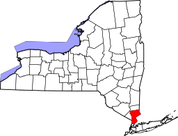 | |
| Towns | ||
| Villages | ||
| CDPs | ||
| Other hamlets | ||
| Footnotes | ‡This populated place also has portions in an adjacent county or counties | |