Bonner Springs, Kansas
| Bonner Springs, Kansas | ||
|---|---|---|
| City | ||
| ||
 Location within Wyandotte County and Kansas | ||
| Coordinates: 39°3′35″N 94°53′1″W / 39.05972°N 94.88361°WCoordinates: 39°3′35″N 94°53′1″W / 39.05972°N 94.88361°W[1] | ||
| Country |
| |
| State |
| |
| Counties | Wyandotte, Johnson, Leavenworth | |
| Settled | 1812 | |
| Platted | 1855 | |
| Incorporated | 1898 | |
| Government | ||
| • Type | Council-Manager | |
| Area[2] | ||
| • Total | 16.09 sq mi (41.67 km2) | |
| • Land | 15.73 sq mi (40.74 km2) | |
| • Water | 0.36 sq mi (0.93 km2) | |
| Elevation[1] | 873 ft (266 m) | |
| Population (2010)[3] | ||
| • Total | 7,314 | |
| • Estimate (2013)[4] | 7,480 | |
| • Density | 450/sq mi (180/km2) | |
| Time zone | Central (CST) (UTC-6) | |
| • Summer (DST) | CDT (UTC-5) | |
| ZIP code | 66012 | |
| Area code | 913 | |
| FIPS code | 20-07975 [1] | |
| GNIS ID | 0478865 [1][5] | |
| Website | BonnerSprings.org | |
Bonner Springs is a city in Johnson, Leavenworth, and Wyandotte counties in the State of Kansas, and part of the Kansas City Metropolitan Area.[1] As of the 2010 census, the city population was 7,314.[6] Bonner Springs is reputed to be the first commercial center and permanent settlement in Kansas in the year 1812. Bonner Springs was incorporated as a City on November 10, 1898.[7]
Bonner Springs is home to several national and regional attractions including the Providence Medical Center Amphitheather, the National Agricultural Center and Hall of Fame, and the annual Kansas City Renaissance Festival.
History
Coronado
Spanish explorer Francisco Vázquez de Coronado spent the winter of 1541-1542 at what is now Bonner Springs. The diary of Father Juan Padilla records that the expedition reached the 40th degree (Kansas northern border) and came to a great river (the Missouri). An inscription found on a stone near Atchison has been translated as, "Thus far came Francisco de Coronado, General of an Expedition." The explorers traveled downstream to the mouth of another great river, the Kansas, and preceded upstream 16 leagues to camp in what is now Bonner Springs before returning to Mexico. Due to the mineral springs, this legend gave the area its first recorded name, Coronado Springs.
Early Settlers
The Kanza tribe had settled the area because of the mineral springs and abundant fish and game when, in 1812, two French fur traders, the Chouteau brothers, made their way from St. Louis Missouri and settled in the area that would become Bonner Springs, starting a trading post named Four Houses. This makes the site of Bonner Springs the first settlement in what would become the State of Kansas.[8] The location allowed easy access to trade items, and ferry to cross the Kansas River was added. In 1830, Henry Tiblow, a Delaware Indian, took charge of the ferry.[9] Tiblow was a Delaware Indian who worked as an interpreter for the government. He lived in a small cabin on the west side of the city.[8]
The location became known as Tiblow Settlement, and the ferry continued working for years.[9] John McDanield, or "Red John" due to hair color, is known as the founder of Bonner Springs - as we know it today. As the owner of a vast majority of land that is now Bonner Springs, McDaniel named the town Tiblow, after his friend Henry.[8]
Mineral Springs
Several of the springs in the area were analysed for their mineral content, and the results indicated benefits that would attract visitors. The Bonner Springs Improvement Club, in 1907, created a promotional brochure touting the city as the “Kansas Karlsbad” and listing the contents of five springs near Lake of the Woods: Big Chief, Little Chief, Papoose, Old Squaw and Minnehaha. They listed “grains per gallon” of things like potassium sulphate, carbonate of iron, and chloride of sodium for each.
Big Chief was noted to be “splendid water for anemics, supplying the necessary properties for good red blood and driving out the dead and impure corpuscles.”
Old Squaw was reportedly so named because “the old women of Indian tribes once living in Kansas found relief from their intense dyspepsia caused by their heavy meat diet and little or no exercise.”
To promote the springs, a special train brought investors to the area and cited its proximity to Kansas City, the springs themselves, the fine parks and native trees, the site of a racetrack, and the beautiful residential sites as advantages that would assure the success of the mineral spring venture. In 1885, Philo Clark purchased 300 acres from McDanield, this plans to capitalize on the mineral springs, then he changed the name of the town to Bonner Springs.[9] The latter portion of the name comes from a mineral spring in the area said to have medicinal qualities.[10][11] The town was also named after Robert E. Bonner, a publisher of the New York Ledger, who was a trotting-horse breeder of note, and Clark believed would help fund the proposed racetrack. However, this is no record this occurred.
Fire of 1908

Bonner Springs continued to be prosperous, with a growing population and new businesses. In 1908, a fire caused over $70,000 - over $350,000 in today's dollars - worth of damage and destroyed between 19 and 21 local businesses.[9] There were no water mains at the time, even though the city council had debated the issue for some time.
Many locals came to the rescue, forming a water bucket chain to help put out the fire, while they waited for a fire truck from Kansas City to arrive.[9] An investigation indicated that materials behind Kelly & Pettit's Drug Store had caught on fire, and the winds carried the flames, making the fire difficult to control.[9] Residents of Bonner Springs undertook thousands of dollars worth of repairs.[12]
Government
The City Council consists of nine members who are elected in non-partisan elections across four wards. The Mayor is elected at large, and together with the Council, select and appoint a professional city manager to operate the city. Operating as the legislative branch of the City, the Council provides policy direction to the City Manager.
The vast majority of Bonner Springs lies in Wyandotte County. Bonner Springs acts as an incorporated city - retaining its own government and autonomy - while also being part of the consolidated city-county government known as the "Unified Government." The UG consolidates the governmental functions of both Wyandotte County and Kansas City, Kansas under one entity, while also performing typical county government functions for the incorporated cities of Bonner Springs and Edwardsville.
Education
Bonner Springs is home to Unified School District 204 which includes Bonner Springs High School, Robert E. Clark Middle School, and three elementary schools.
Geography
Bonner Springs is located at 39°03′35″N 94°53′01″W / 39.0597260°N 94.8835754°W (39.0597260, -94.8835754),[1][13] along both banks of the Kansas River. According to the United States Census Bureau, the city has a total area of 16.09 square miles (41.67 km2), of which, 15.73 square miles (40.74 km2) is land and 0.36 square miles (0.93 km2) is water.[2]
Climate
Bonner Springs lies in the transition zone between North America's humid subtropical climate and humid continental climate zones, typically experiencing hot, humid summers and cold, dry winters.[14]
| Climate data for Bonner Springs, Kansas | |||||||||||||
|---|---|---|---|---|---|---|---|---|---|---|---|---|---|
| Month | Jan | Feb | Mar | Apr | May | Jun | Jul | Aug | Sep | Oct | Nov | Dec | Year |
| Record high °F (°C) | 74 (23) |
81 (27) |
85 (29) |
91 (33) |
95 (35) |
105 (41) |
114 (46) |
107 (42) |
106 (41) |
98 (37) |
84 (29) |
76 (24) |
114 (46) |
| Average high °F (°C) | 38 (3) |
45 (7) |
56 (13) |
67 (19) |
76 (24) |
84 (29) |
91 (33) |
88 (31) |
80 (27) |
70 (21) |
54 (12) |
42 (6) |
66 (19) |
| Average low °F (°C) | 20 (−7) |
25 (−4) |
35 (2) |
45 (7) |
55 (13) |
64 (18) |
69 (21) |
66 (19) |
58 (14) |
47 (8) |
35 (2) |
24 (−4) |
45 (7) |
| Record low °F (°C) | −18 (−28) |
−12 (−24) |
−8 (−22) |
13 (−11) |
30 (−1) |
43 (6) |
48 (9) |
46 (8) |
30 (−1) |
18 (−8) |
1 (−17) |
−22 (−30) |
−22 (−30) |
| Average precipitation inches (mm) | 1.26 (32) |
1.27 (32.3) |
2.74 (69.6) |
3.78 (96) |
5.41 (137.4) |
5.22 (132.6) |
4.03 (102.4) |
3.56 (90.4) |
4.69 (119.1) |
3.48 (88.4) |
2.97 (75.4) |
1.76 (44.7) |
40.17 (1,020.3) |
| Average snowfall inches (cm) | 5.70 (14.48) |
4.00 (10.16) |
2.90 (7.37) |
0.50 (1.27) |
0 (0) |
0 (0) |
0 (0) |
0 (0) |
0 (0) |
0.10 (0.25) |
1.10 (2.79) |
3.00 (7.62) |
17.30 (43.94) |
| Source: [15] | |||||||||||||
Demographics
| Historical population | |||
|---|---|---|---|
| Census | Pop. | %± | |
| 1900 | 609 | — | |
| 1910 | 1,447 | 137.6% | |
| 1920 | 1,599 | 10.5% | |
| 1930 | 1,837 | 14.9% | |
| 1940 | 1,837 | 0.0% | |
| 1950 | 2,277 | 24.0% | |
| 1960 | 3,171 | 39.3% | |
| 1970 | 3,884 | 22.5% | |
| 1980 | 6,266 | 61.3% | |
| 1990 | 6,413 | 2.3% | |
| 2000 | 6,768 | 5.5% | |
| 2010 | 7,314 | 8.1% | |
| Est. 2015 | 7,606 | [16] | 4.0% |
| U.S. Decennial Census[17] 2013 Estimate[4] | |||
2010 census
As of the census[3] of 2010, there were 7,314 people, 2,810 households, and 1,917 families residing in the city. The population density was 465.0 inhabitants per square mile (179.5/km2). There were 3,025 housing units at an average density of 192.3 per square mile (74.2/km2). The racial makeup of the city was 84.8% White, 5.4% African American, 0.9% Native American, 0.5% Asian, 0.1% Pacific Islander, 5.0% from other races, and 3.3% from two or more races. Hispanic or Latino of any race were 10.8% of the population.
There were 2,810 households of which 35.2% had children under the age of 18 living with them, 48.6% were married couples living together, 14.2% had a female householder with no husband present, 5.5% had a male householder with no wife present, and 31.8% were non-families. 25.7% of all households were made up of individuals and 9.8% had someone living alone who was 65 years of age or older. The average household size was 2.59 and the average family size was 3.11.
The median age in the city was 35.7 years. 26.5% of residents were under the age of 18; 8.8% were between the ages of 18 and 24; 26.8% were from 25 to 44; 26.2% were from 45 to 64; and 11.8% were 65 years of age or older. The gender makeup of the city was 47.9% male and 52.1% female.
2000 census
As of the census of 2000, there were 6,768 people, 2,592 households, and 1,824 families residing in the city. The population density was 429.4 people per square mile (165.8/km2). There were 2,754 housing units at an average density of 174.7 per square mile (67.5/km2). The racial makeup of the city was 90.2% White, 4.1% African American, 0.8% Native American, 0.5% Asian, 2.7% from other races, and 1.7% from two or more races. Hispanic or Latino of any race were 6.2% of the population. 22.1% were of German, 13.3% American, 12.8% Irish and 10.9% English ancestry.
There were 2,592 households out of which 35.8% had children under the age of 18 living with them, 53.5% were married couples living together, 12.6% had a female householder with no husband present, and 29.6% were non-families. 24.7% of all households were made up of individuals and 10.8% had someone living alone who was 65 years of age or older. The average household size was 2.59 and the average family size was 3.11.
In the city the population was spread out with 28.2% under the age of 18, 8.5% from 18 to 24, 29.8% from 25 to 44, 20.7% from 45 to 64, and 12.8% who were 65 years of age or older. The median age was 34 years. For every 100 females there were 93.7 males. For every 100 females age 18 and over, there were 87.2 males.
As of 2000 the median income for a household in the city was $43,234, and the median income for a family was $50,476. Males had a median income of $36,390 versus $26,957 for females. The per capita income for the city was $19,730. About 6.8% of families and 9.6% of the population were below the poverty line, including 12.9% of those under age 18 and 5.4% of those age 65 or over.
Arts and culture
Providence Medical Center Amphitheater

Bonner Springs is home to the Providence Medical Center Amphitheater, first opened in 1984 as the Sandstone Amphitheater. This open-air venue can seat an 18,000 guests, including 3,100 box and reserved seats. The venue has undergone renovations, including an improved layout for seating and state-of-the-art sound and video systems.
National Agricultural Center and Hall of Fame

Bonner Springs is home to the National Agricultural Center and Hall of Fame, a privately funded charitable institution chartered by the U.S. Congress to "educate society on the historical and present value of American agriculture and to honor leadership in Agri-Business and Academia by providing education, information, experience and recognition."[18]
Kansas City Renaissance Festival
The city is host of the annual Kansas City Renaissance Festival.[19] The fair begins on Labor Day weekend and continues for seven weekends, open on Saturdays and Sundays as well as Labor Day and Columbus Day. The fair began in 1977 as a benefit for the Kansas City Art Institute, and became a stand-alone event in the late 1990s. The fair has 165 booths and 13 stages, entertaining 180,000 patrons annually on 16 operating days.
Wyandotte County Park
Wyandotte County Park has numerous picnic areas with A-frame structures. The park also includes soccer fields, tennis courts, a skate park, disc golf course, a model airplane flying area, and baseball diamonds. The Park is home to numerous attractions, including the Wyandotte County Museum and Historical Society, Trowbridge Archival Library, and the George Meyn Community Center. Sunflower Hills Golf Course, opened in 1977, is an 18-hole course located at Wyandotte County Park.
Tiblow Days
Each year, during the last weekend of August, the city hosts Tiblow Days, a heritage festival in honor of early settler Henry Tiblow, and former name of the community.[20]
Transportation
See related article: voy:Kansas City (Missouri) at Wikivoyage
River transportation was important to early Bonner Springs, Kansas, as its directly located on the Kansas River afforded easy access to trade. A portion of I-70 was the first project in the United States completed under the provisions of the new Federal-Aid Highway Act of 1956 (though not the first constructed or to begin construction). Bonner Springs is located directly on or near several transportation corridors including roadways, rail, and river access.
Road Transportation
Bonner Springs is served directly by two interstate highways, three national highways, three state highways and many influential Kansas City Metro roads:
Direct Routes
Bonner Springs is served with direct routes to one interstate highway, two state highways and one national highway:
Notable people
Notable individuals who were born in and/or have lived in Bonner Springs include:
- David Jaynes (1952- ), football quarterback[21]
- Ed Nealy (1960- ), basketball power forward[22]
- Myra Taylor (1917-2011), jazz singer-songwriter[23]
- Bobby Watson (1953- ), saxophonist[24]
- Gene Clark (1944-1991), singer and founding member of The Byrds
See also
References
- 1 2 3 4 5 6 Geographic Names Information System (GNIS) details for Bonner Springs, Kansas; United States Geological Survey (USGS); October 13, 1978.
- 1 2 "US Gazetteer files 2010". United States Census Bureau. Archived from the original on January 24, 2012. Retrieved July 6, 2012.
- 1 2 "American FactFinder". United States Census Bureau. Retrieved July 6, 2012.
- 1 2 "Population Estimates". United States Census Bureau. Retrieved August 21, 2014.
- ↑ "US Board on Geographic Names". United States Geological Survey. October 25, 2007. Retrieved January 31, 2008.
- ↑ "2010 City Population and Housing Occupancy Status". U.S. Census Bureau. Archived from the original on July 21, 2011. Retrieved March 6, 2011.
- ↑ Morgan, Perl Wilbur (1911). History of Wyandotte County, Kansas: And Its People, Volume 1. The Lewis Publishing Company. p. 321.
- 1 2 3 Miller, Rober B. (2013). Bonner Springs (Images of America. USA: Arcadia Publishing Publishing. p. 7. ISBN 1467110434.
- 1 2 3 4 5 6 Boyer, Carolyn (March 10, 2014). "Five Things You Might Not Know about Bonner Springs". Dolph C. Simons Jr. The Chieftain. Retrieved April 27, 2015.
- ↑ Blackmar, Frank Wilson (1912). Kansas: A Cyclopedia of State History, Embracing Events, Institutions, Industries, Counties, Cities, Towns, Prominent Persons, Etc. Standard Publishing Company. p. 205.
- ↑ "Bonner Springs History". City of Bonner Springs, Kansas. Retrieved June 12, 2014.
- ↑ "Bonner Springs History". City of Bonner Springs, Kansas. Retrieved April 27, 2015.
- ↑ "US Gazetteer files: 2010, 2000, and 1990". United States Census Bureau. February 12, 2011. Retrieved April 23, 2011.
- ↑ Peel, M. C., Finlayson, B. L., and McMahon, T. A.: Updated world map of the Köppen-Geiger climate classification, Hydrol. Earth Syst. Sci., 11, 1633–1644, doi:10.5194/hess-11-1633-2007, 2007.
- ↑ Intellicast
- ↑ "Annual Estimates of the Resident Population for Incorporated Places: April 1, 2010 to July 1, 2015". Retrieved July 2, 2016.
- ↑ United States Census Bureau. "Census of Population and Housing". Archived from the original on May 11, 2015. Retrieved October 24, 2013.
- ↑ "Our Purpose". National Agricultural Center. Retrieved December 30, 2015.
- ↑ Draper, Bill (August 15, 2003). "Off with its head?". The Topeka Capital-Journal. Retrieved February 17, 2010.
- ↑ "Henry Tiblow". ancestry.com.
- ↑ "David Jaynes". Pro-Football-Reference.com. Retrieved April 1, 2016.
- ↑ "Ed Nealy". Basketball-Reference.com. Retrieved April 1, 2016.
- ↑ Gross, Sylvia Maria; Spencer, Laura (December 12, 2011). "Kansas City Jazz Singer And Wild Woman Myra Taylor Dies At 94". KCUR. Retrieved April 1, 2016.
- ↑ Spencer, Laura; Denesha, Julie (August 19, 2013). "Kansas City Creative Couples: Watson & Baskin-Watson". KCUR. Retrieved April 1, 2016.
Further reading
- County
- History of Leavenworth County Kansas; Jesse Hall and LeRoy Hand; Historical Publishing; 684 pages; 1921. (Download 27MB PDF eBook)
- Kansas
- History of the State of Kansas; William G. Cutler; A.T. Andreas Publisher; 1883. (Online HTML eBook)
- Kansas : A Cyclopedia of State History, Embracing Events, Institutions, Industries, Counties, Cities, Towns, Prominent Persons, Etc.; 3 Volumes; Frank W. Blackmar; Standard Publishing Co; 944 / 955 / 824 pages; 1912. (Volume1 – Download 54MB PDF eBook),(Volume2 – Download 53MB PDF eBook), (Volume3 – Download 33MB PDF eBook)
External links
| Wikimedia Commons has media related to Bonner Springs, Kansas. |
- City
- City of Bonner Springs
- Bonner Springs – Directory of Public Officials
- Bonner Springs / Edwardsville Area Chamber of Commerce
- Schools
- USD 204, local school district
- Maps
- Bonner Springs City Map, BonnerSprings.org
- Bonner Springs City Map, KDOT
Municipalities and communities of Johnson County, Kansas, United States | ||
|---|---|---|
| Cities | 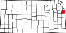 | |
| Unincorporated communities | ||
| Townships | ||
| Footnotes | ‡This populated place also has portions in an adjacent county or counties | |
Municipalities and communities of Leavenworth County, Kansas, United States | ||
|---|---|---|
| Cities | 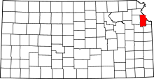 | |
| CDPs | ||
| Unincorporated communities | ||
| Townships |
| |
| Ghost town | ||
| Footnotes | ‡This populated place also has portions in an adjacent county or counties | |
Municipalities and communities of Wyandotte County, Kansas, United States | ||
|---|---|---|
| Cities |  | |
| Neighborhoods in Kansas City |
| |
| Footnotes | ‡This populated place also has portions in an adjacent county or counties | |
Kansas City metropolitan area's cities and counties | ||
|---|---|---|
| Central city | 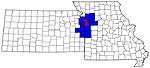 | |
| Largest cities (over 100,000 in 2000) | ||
| Medium-sized cities (10,000 to 100,000 in 2000) | ||
| Smaller Cities (between 5,000 and 9,900 in 2010) | ||
| Counties | ||