Bon Irau
| Bon Irau | |
|---|---|
| Highest point | |
| Elevation | 2,501 m (8,205 ft) |
| Listing |
Ultra Ribu |
| Coordinates | 0°39′43″S 132°53′21″E / 0.6619262°S 132.8892517°ECoordinates: 0°39′43″S 132°53′21″E / 0.6619262°S 132.8892517°E |
| Geography | |
| Location | Bird's Head Peninsula; Arfak Mountains Regency; Manokwari Regency; West Papua; Indonesia |
| Parent range | Tamrau Mountains |
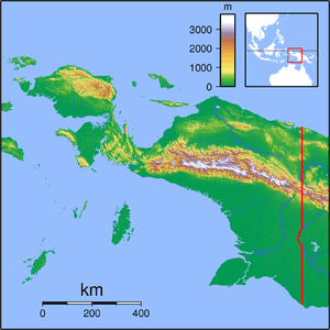
Bon Irau, with an elevation of 2,501 metres (8,205 ft), is the highest peak in the Tamrau Mountains and the highest point in the province of West Papua outside of the Arfak Mountains. It is located in the north central region of the Bird's Head Peninsula and located around 20 kilometres (12 mi) from the grassy Kebar Valley.
References
- WWF Bird Watching on Bird's Head, and the Threats to the Region Vogelkop Montane Rain Forests. Accessed 5 March 2015
- Arfak Mountains: Birding Hotspot of West Papua Accessed 5 March 2015
This article is issued from Wikipedia - version of the 8/31/2015. The text is available under the Creative Commons Attribution/Share Alike but additional terms may apply for the media files.