Bolinas, California
| Bolinas | |
|---|---|
| Census designated place | |
|
street scene in Bolinas, 2009 | |
 Location in Marin County and the state of California | |
 Bolinas Location in the United States | |
| Coordinates: 37°54′34″N 122°41′11″W / 37.90944°N 122.68639°WCoordinates: 37°54′34″N 122°41′11″W / 37.90944°N 122.68639°W | |
| Country | United States of America |
| State | California |
| County | Marin |
| Government | |
| • Type | unincorporated |
| • Supervisor | Steve Kinsey District 4 |
| • State senator | Mike McGuire (D)[1] |
| • Assemblymember | Marc Levine (D)[1] |
| • U. S. rep. | Jared Huffman (D)[2] |
| Area[3] | |
| • Total | 5.826 sq mi (15.091 km2) |
| • Land | 5.826 sq mi (15.091 km2) |
| • Water | 0 sq mi (0 km2) 0% |
| Elevation[4] | 36 ft (11 m) |
| Population (April 1, 2010) | |
| • Total | 1,620 |
| • Density | 280/sq mi (110/km2) |
| Time zone | Pacific (UTC-8) |
| • Summer (DST) | PDT (UTC-7) |
| ZIP code | 94924 |
| Area codes | 415/628 |
| FIPS code | 06-07316 |
| GNIS feature IDs | 277476, 2407875 |

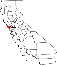
Bolinas is an unincorporated coastal community in Marin County, California.[5] The census designated place is located on the California coast, approximately 13 miles (21 km) northwest of San Francisco by air.
The community is known for its reclusive residents. It is only accessible via unmarked roads; any road sign along State Route 1 that points the way into town has been torn down by local residents,[6] to the point where county officials offered a ballot measure to which the voters responded by stating a preference for no more signs.[7]
Geography
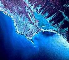
Bolinas sits at an elevation of 36 feet (11 m) above sea level.[4] It is bound on the northeast by Bolinas Lagoon and Kent Island and on the south by Bolinas Bay and Duxbury Point.[4] According to the United States Census Bureau, the CDP has a total area of 5.8 square miles (15 km2), all of it land. The GNIS has cited archaic alternate town-names, including "Ballenas", "Baulenas", "Baulings", and "Bawlines".[4]
Bolinas' downtown is located on the eastern side of town along Wharf Road, which ends at Bolinas Lagoon. Downtown's buildings were mostly built between 1850 and 1920. Brighton Avenue connects downtown to the south-facing Brighton Beach. In the southeast corner of town is the Little Mesa. The Big Mesa, also known as the Gridded Mesa, lies to the west, with Agate Beach at its western end.
By air, Bolinas is just 10 miles (16 km) west-southwest of San Rafael,[8] and 13 miles (21 km) northwest of San Francisco. While located just 2 miles (3.2 km) from State Route 1, the area is not very accessible by car. The driving time from San Rafael is roughly 52 minutes, and it takes over an hour to drive to downtown San Francisco.[9]
Bolinas lies west of the San Andreas Fault, which runs the length of Bolinas Lagoon and continues northward through Olema Valley and Tomales Bay. Bolinas and the Point Reyes peninsula are on the Pacific Plate, moving north relative to Stinson Beach and the North American Plate at an average rate of about 1 inch (2.5 cm) per year.
Point Reyes National Seashore borders Bolinas to the northwest. Duxbury Reef State Marine Conservation Area encompasses Bolinas' western shoreline.
History
Bolinas and present day Stinson Beach were once encompassed by Rancho Las Baulines, a Mexican land grant given by Governor Pío Pico to Gregorio Briones in 1846.[8][10][11]
The first post office in the town of Bolinas opened in 1863.[8]


In 1927, a 300-acre former dairy farm on the Big Mesa was subdivided into a grid of streets and 5,336 lots measuring 20' by 100'. Many of these lots were sold for $69.50 by the San Francisco Bulletin as a subscription promotion. Portions of the mesa, including sections of Ocean Parkway, have since eroded into the sea. A few streets on the mesa are paved and maintained by the county, but many are unpaved, and either maintained by adjoining property owners or completely unmaintained.[12] The Big Mesa has no sewer system, and houses on the mesa have individual septic systems.[12][13]
In 1967, the Bolinas Community Public Utility District was formed by the Marin County Board of Supervisors. It merged two local water districts, the Bolinas Beach Public Utility District which served the Big Mesa, and the Bolinas Public Utility District which served the Downtown and Little Mesa, with the Marin County Sanitary District #3, formed in 1908 to provide sewer service in the downtown. The BCPUD provides water service and solid waste pickup throughout Bolinas, and sewer service to the Downtown and Little Mesa.[13]
Bolinas' beaches were hit hard by the 1971 San Francisco Bay oil spill, with the community coming together to clean the beach of crude oil.
In November 1971, the Bolinas Community Public Utility District instituted a moratorium on new water permits, which halted the construction of new homes. The moratorium was based on the limited local water supply during the summer months and in drought years, and also serves to limit new development in Bolinas.[12] In 1990, the BCPUD enacted a moratorium on new sewer connections, to address the limited capacity of the sewage collection system.[13] Many lots, especially on the Big Mesa, remain undeveloped.
Bolinas and its reclusive reputation are featured in the 1981 novel Ecotopia Emerging by Ernest Callenbach. In November 2003, Bolinas voters adopted Measure G, an advisory ballot measure declaring Bolinas "A socially acknowledged nature-loving town".[14]
Demographics
- 2010
The 2010 United States Census reported that the Bolinas CDP (Census-designated place) had a population of 1,620.[15] The population density was 278.0 people per square mile (107.4/km²). The racial makeup of Bolinas was 1,406 (86.8 percent) White, 27 (1.7 percent) African American, 10 (0.6 percent) Native American, 17 (1.0 percent) Asian, 14 (0.9 percent) Pacific Islander, 64 (4.0 percent) from other races, and 82 (5.1 percent) from two or more races. Hispanic or Latino of any race were 260 persons (16.0 percent).
The Census reported that 88.4 percent of the population lived in households and 11.6 percent lived in non-institutionalized group quarters.
There were 698 households, out of which 144 (20.6 percent) had children under the age of 18 living in them, 259 (37.1 percent) were opposite-sex married couples living together, 54 (7.7 percent) had a female householder with no husband present, 32 (4.6 percent) had a male householder with no wife present. There were 49 (7.0 percent) unmarried opposite-sex partnerships, and nine (1.3 percent) same-sex married couples or partnerships. There were 280 households (40.1 percent) made up of individuals and 98 (14.0 percent) had someone living alone who was 65 years of age or older. The average household size was 2.05. There were 345 families (49.4 percent of all households); the average family size was 2.65.
The population was spread out with 234 people (14.4 percent) under the age of 18, 76 people (4.7 percent) aged 18 to 24, 385 people (23.8 percent) aged 25 to 44, 642 people (39.6 percent) aged 45 to 64, and 283 people (17.5 percent) who were 65 years of age or older. The median age was 49.3 years. For every 100 females there were 115.1 males. For every 100 females age 18 and over, there were 113.6 males.
There were 986 housing units at an average density of 169.2 per square mile (65.3/km²), of which 57.4 percent were owner-occupied, and 42.6 percent were occupied by renters. The homeowner vacancy rate was 1.7 percent; the rental vacancy rate was 2.6 percent. 54.1 percent of the population lived in owner-occupied housing units and 34.3 percent lived in rental housing units.
- 2000


As of the census[16] of 2000, there were 1,246 people, 486 households, and 260 families residing in the CDP. The population density was 900.6 people per square mile (348.6/km²). There were 629 housing units at an average density of 454.7 per square mile (176.0/km²). The racial makeup of the CDP in 2000 was 77.7 percent non-Hispanic White, 0.5 percent non-Hispanic Black or African American, 0.2 percent Native American, 0.9 percent Asian, 0.2 percent Pacific Islander, 0.1 percent from other races, and 4.3 percent from two or more races. 16.0 percent of the population were Hispanic or Latino of any race.
There were 486 households out of which 27.4 percent had children under the age of 18 living with them, 39.9 percent were married couples living together, 10.5 percent had a female householder with no husband present, and 46.3 percent were non-families. Of all households, 32.1 percent were made up of individuals and 4.5 percent had someone living alone who was 65 years of age or older. The average household size was 2.29 and the average family size was 2.87.
In the CDP the population was spread out with 21.0 percent under the age of 18, 4.7 percent from 18 to 24, 26.0 percent from 25 to 44, 40.3 percent from 45 to 64, and 8.0 percent who were 65 years of age or older. The median age was 44 years. For every 100 females there were 110.8 males. For every 100 females age 18 and over, there were 102.1 males.
The median income for a household in the CDP was $53,188, and the median income for a family was $56,111. Males had a median income of $48,281 versus $40,417 for females. The per capita income for the CDP was $28,973. About 5.5% of families and 10.2 percent of the population were below the poverty line, including 6.7 percent of those under age 18 and 2.8 percent of those age 65 or over.
The much larger area defined by the Census Bureau as Zip Code Tabulation Area 94924, which includes Horseshoe Hill, Dogtown, and Five Brooks, had a 2000 population of 1,560 people (see map).[17]
Education
Bolinas is in the Bolinas-Stinson Union School District, the Tamalpais Union High School District, and the Marin Community College District. Students in primary grades (kindergarten – grade 2) attend Stinson Beach School, while elementary grade students (grades 3–8) attend Bolinas School. Bolinas is included in the attendance area of Tamalpais High School, in Mill Valley.
In 1951, Ford Times identified Bolinas as the first in its series of "Tom Sawyer Towns... a good place for boys and girls to live and grow... its school days, its summer vacations, its vast adventures in fishing, swimming, baseball, basking and dreaming in the sun. Such a place is Bolinas."[18]
Government
Bolinas is unincorporated, receiving general government services from Marin County, including law enforcement, land use planning, public health, and code enforcement. Two special districts provide local services. The Bolinas Community Public Utility District provides water and wastewater service and contracts for garbage and recycling collection.[19] The Bolinas Fire Protection District provides fire protection, emergency medical care, and disaster management services.[20]
Regional recreation and marine protected areas
Besides the public access beach near the downtown area, there is a county park, Agate Beach, which contains extensive tide pools that are protected as part of the Gulf of the Farallones National Marine Sanctuary. The town also hosts the Marin-Bolinas Botanical Gardens, and borders on the Point Reyes National Seashore to the north. Alamere Falls, one of only two beach waterfalls in the continental U.S., is on the California Coastal Trail from Palomarin Trailhead at the end of Mesa Rd.
Duxbury Reef State Marine Conservation Area lies offshore from Bolinas. Like an underwater park, this marine protected area helps conserve ocean wildlife and marine ecosystems.
Notable residents
Bolinas has a reputation as an art colony, with many artists and counter-culture figures having lived there, including briefly, Richard Brautigan. Aram Saroyan, son of author William Saroyan, wrote the preface of his book Last Rites from Bolinas, CA in 1982.
See also
References
- 1 2 "Statewide Database". Regents of the University of California. Retrieved February 26, 2015.
- ↑ "California's 2nd Congressional District - Representatives & District Map". Civic Impulse, LLC. Retrieved March 8, 2013.
- ↑ "2010 Census U.S. Gazetteer Files – Places – California". United States Census Bureau.
- 1 2 3 4 U.S. Geological Survey Geographic Names Information System: Bolinas, California
- ↑ "Marin County Local Coastal Program". Co.marin.ca.us. Retrieved 2011-12-20.
- ↑ "Bolinas Journal; Welcome to Bolinas; Please Keep On Moving". New York Times. 2000-07-09. Retrieved 2011-12-20.
- ↑ "Road Signs? Bolinas Voters Say 'Read Our Lips' Instead". Los Angeles Times. 1989-11-09. Retrieved 2013-11-16.
- 1 2 3 Durham, David L. (1998). California's Geographic Names: A Gazetteer of Historic and Modern Names of the State. Clovis, Calif.: Word Dancer Press. p. 605. ISBN 1-884995-14-4.
- ↑ Google Maps directions
- ↑ Ogden Hoffman, 1862, Reports of Land Cases Determined in the United States District Court for the Northern District of California
- ↑ http://www.co.marin.ca.us/depts/lb/main/crm/maps/MarinRanchosMap.swf
- 1 2 3 "A Plan for the Bolinas Gridded Mesa", Bolinas Planning Council and The Marin County Planning Department, 1984.
- 1 2 3 "Sewer System Management Plan". Bolinas Community Public Utility District, April 2008.
- ↑ "Measure G: Bolinas Socially Acknowledged Nature Loving Town". Smart Voter, November 20, 2003. Accessed January 20, 2015.
- ↑ "2010 Census Interactive Population Search: CA - Bolinas CDP". U.S. Census Bureau. Retrieved July 12, 2014.
- ↑ "American FactFinder". United States Census Bureau. Archived from the original on 2013-09-11. Retrieved 2008-01-31.
- ↑ "94924 - Fact Sheet - American FactFinder". Factfinder.census.gov. Retrieved 2011-12-20.
- ↑ Corliss, J. Ray (March 1951). "Bolinas, California". Ford Times. 43 (3): 2–11.
- ↑ "Bolinas Community Public Utility District". Bcpud.org. 2011-12-16. Retrieved 2011-12-20.
- ↑ "Bolinas Fire Protection District | Home". Bolinasfire.org. Retrieved 2011-12-20.
Further reading
- Bullis, Mabel Dodge (1974). Early Bolinas Memories. Berkeley, Calif.: Wesley Tanner. p. 20. OCLC 10328789.
- Dibblee, Harrison (1940). Epic of Bolinas. Dallas, Texas: The Kaleidograph Press. p. 22. OCLC 14635050.
- Frank, Phil; Kendrick Rand; Tamae Agnoli (2004). Bolinas and Stinson Beach. Images of America: California. Bolinas Museum and Stinson Beach Historical Society. Arcadia Publishing. p. 128. OCLC 57345826.
- Mason, Jack; Thomas J. Barfield (1973). Last Stage for Bolinas. Inverness, Calif.: North Shore Books. p. 168. OCLC 750529.
- Reich, Charles A. (1976). The Sorcerer of Bolinas Reef. New York: Random House. p. 266. OCLC 2388044.
- Schell, Orville (1976). The Town That Fought To Save Itself. Photos by Ilka Hartmann. New York: Pantheon Books. p. 200. OCLC 1976726.
External links
- Bolinas Beach from the air, 2005 (California Coastal Records Project)
- Bolinas Library
- Bolinas Community Land Trust (BCLT) (Affordable, community housing, preserving the human ecosystem, and the natural ecology of Bolinas.)
- Bolinas Museum
- The Coastal Post
- Bolinas Community Center
- New York Times article on Bolinas Culture
- Bolinas Literary History by Kevin Opstedal
- Dreaming As One: Poetry, Poets and Community in Bolinas, California, 1967-1980 by Kevin Opstedal
 Point Reyes National Seashore travel guide from Wikivoyage
| Bodies of water |
|  |
|---|---|---|
| Counties | ||
| Major cities | ||
| Cities and towns 100k–250k | ||
| Cities and towns 50k–99k | ||
| Cities and towns 25k-50k | ||
| Cities and towns 10k–25k |
| |
| Sub-regions | ||