Bolberry Down
Coordinates: 50°13′54″N 3°50′36″W / 50.231694°N 3.843282°W

Cliff at Bolberry Down, Bolberry.
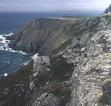
Cliffs west of Slippery Point.
Bolberry Down is a clifftop area on the coast of Devon, England. The headland of Bolt Tail lies to the west and Bolt Head and the town of Salcombe to the east. It is one of the longest coastal areas owned by the National Trust and lies within the South Devon Area of Outstanding Natural Beauty.
It offers views to Bantham Beach and Burgh Island. During the Second World War it was used as a Royal Air Force station and the old concrete buildings and disused runway can still be seen.
External links
Bolberry Down at South Devon AONB
This article is issued from Wikipedia - version of the 11/5/2016. The text is available under the Creative Commons Attribution/Share Alike but additional terms may apply for the media files.