Bolívar Department
| Department of Bolívar Departamento de Bolívar | |||
|---|---|---|---|
| Department | |||
| |||
|
Motto: Ab Ordine Libertas (Latin: From order comes freedom) | |||
| Anthem: Himno de Bolívar | |||
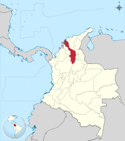 Bolívar shown in red | |||
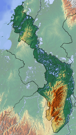 Topography of the department | |||
| Coordinates: 10°24′N 75°30′W / 10.400°N 75.500°WCoordinates: 10°24′N 75°30′W / 10.400°N 75.500°W | |||
| Country |
| ||
| Region | Caribbean Region | ||
| Established | June 15, 1857 | ||
| Capital | Cartagena | ||
| Government | |||
| • Governor | Dumek Jose Turbay Paz (2016-2019) | ||
| Area[1][2] | |||
| • Total | 25,978 km2 (10,030 sq mi) | ||
| Area rank | 14th | ||
| Population (2013)[3] | |||
| • Total | 2,049,083 | ||
| • Rank | 6th | ||
| • Density | 79/km2 (200/sq mi) | ||
| Time zone | UTC-05 | ||
| ISO 3166 code | CO-BOL | ||
| Provinces | 6 | ||
| Municipalities | 46 | ||
| Website | www.bolivar.gov.co | ||
.svg.png)
.svg.png)
Bolívar is a department of Colombia. It was named after one of the original nine states of the United States of Colombia. It is located to the north of the country, extending roughly north-south from the Caribbean coast at Cartagena near the mouth of the Magdalena River, then south along the river to a border with Antioquia Department. The departments of Sucre and Córdoba are located to the west, and Atlántico Department is to the north and east (most of the border formed by the Canal del Dique). Across the Magdalena River to the east is Magdalena Department. The flag of the department bears a resemblance to the flag of Lithuania.
Its capital is Cartagena. Other important cities include Magangué and Turbaco.
Provinces and Municipalities
Depresión MomposinaDique |
Loba
Magdalena Medio |
MojanaMontes de Maria |
History
In today's villages of Maria La Baja, Sincerín, El Viso, and Mahates and Rotinet, excavations have uncovered the remains of maloka-type buildings, directly related to the early Puerto Hormiga settlements.[4]
Miscellaneous
References
- ↑ "Información Institucional: Geografía" (in Spanish). Gobernación del Bolivar. 2011. Archived from the original on 5 March 2012.
- ↑ Kline, Harvey F. (2012). "Bolivar, Department of". Historical Dictionary of Colombia. Lanham, Maryland: Scarecrow Press. p. 83. ISBN 978-0-8108-7813-6.
- ↑ "DANE". Retrieved February 13, 2013.
- ↑ "Universidad del Norte". Uninorte.edu.co. Retrieved 2010-06-24.
External links
| Wikimedia Commons has media related to Departamento de Bolívar. |
| Wikivoyage has a travel guide for Bolívar Department. |
- View a boundary-overlaid version of Bolívar on Google Maps: http://www.maplandia.com/colombia/bolivar/turbana/
 Chisholm, Hugh, ed. (1911). "Bolívar (Colombia)". Encyclopædia Britannica (11th ed.). Cambridge University Press.
 | ||