Bodie Island
Bodie Island (pronounced, "body" as in the human body) is a long, narrow barrier peninsula that forms the northernmost portion of the Outer Banks. The land that is most commonly referred to as Bodie Island was at one time a true island, however in 1811 Roanoke inlet that separated it from the Currituck Banks in the north closed.[1] As a result, the Currituck Banks and Bodie Island are now one contiguous peninsula, joined together at the Nags Head area, where the inlet once flowed. Today, either name can be used to refer to peninsula as a whole, but both portions colloquially retain their historical names.
From the southern tip at Oregon Inlet, the peninsula stretches largely northwest out of North Carolina and into Virginia Beach, Virginia to join the mainland at Sandbridge near the north shore of Back Bay. The entire peninsula is approximately 72 miles in length, following the shoreline.
Places of interest
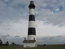
The peninsula is home to two lighthouses, Bodie Island Light and Currituck Beach Light. The Wright Brothers National Monument also has a beacon and is found on the peninsula. Jockey's Ridge, the tallest sand dune on the East Coast, is found on the peninsula. The Cape Hatteras National Seashore protects the southernmost part of Bodie Island, and the Currituck National Wildlife Refuge, Back Bay National Wildlife Refuge and False Cape State Park protect portions of the northern part of the peninsula.
History
Bodie Island was originally known as Bodie's Island or Body's Island and was named for a family variously named "Body" "Boddye" "Boddy" and "Bodie" that settled there. Robert Boddy/Boddie emigrated to Virginia from London, England on August 10, 1635 on the HMS Safety.[2] He settled in the Isle of Wight, Virginia and his descendants settled in what became Virginia, North Carolina, South Carolina and Mississippi and Bodie island was named for his descendants who settled the area. The family was originally from Ingatestone, Essex, England which is where their coat of arms originated as well, granted for service during the naval battle with the Spanish Armada. Their history is noted in Seventeenth Century Isle of Wight County, Virginia[3] Folklore sometimes attributes the naming of the island to the dead "bodies" of drowned sailors that washed up from the ships that ran aground and sank off the Outer Banks in what is now known as the Graveyard of the Atlantic.
Inlets frequently open and close along the Outer Banks, making landform naming inconsistent. Bodie Island, when it was an island, extended farther south than it does today. The island was originally formed around 1738, when New Inlet opened, separating Bodie Island from Hatteras Island to the south. The opening of Oregon Inlet in 1846 truncated the southern portion of Bodie Island, forming a new island situated between Bodie and Hatteras. The new barrier island was given the name Pea Island, but the wider, more powerful Oregon Inlet led to the eventual closure of New Inlet around 1933. Pea Island had thus became a part of Hatteras Island until 2011 when New Inlet reopened during Hurricane Irene.
Near the North Carolina-Virginia state line, the Currituck Inlet and Musketo Inlets along with Caffey's Inlet to the south in the vicinity of Duck once existed, which made the Currituck Banks itself a chain of islands. Currituck inlet served as the boundary between the two states in the early 18th century. Caffey's Inlet closed in 1811, New Currituck Inlet had closed by 1828 and Musketo Inlet finally closed in 1882 creating the long peninsula extending from Sandbridge to Oregon Inlet that is seen today.[4]
Explorer John Lawson mentions Bodies Island just once in his 1709 book A New Voyage to Carolina, when discussing fauna of North Carolina, in particular a species of rabbit. He wrote the following: "I was told of several that were upon Bodies Island by Ronoak, which came from that Ship of Bodies;" This would indicate that Bodie Island was so named as early as 1709.
Localities
The following is a list of places found on the peninsula, listed from south to north.
- Nags Head, North Carolina
- Kill Devil Hills, North Carolina
- Kitty Hawk, North Carolina
- Southern Shores, North Carolina
- Duck, North Carolina
- Corolla, North Carolina
- Carova Beach, North Carolina
- Sandbridge, Virginia
Accessibility
Bodie Island can be accessed from North Carolina mainland from the Wright Memorial Bridge, originally built in 1966.[5] It can also be accessed from U.S. Route 64 since the Washington Baum Bridge opened in 1994.[6] Motorists driving north on the Outer Banks from Hatteras and Pea Islands reach the Currituck Banks on NC highway 12.
The north end of the peninsula is accessible by Sandpiper and Sandfiddler Roads via Sandbridge Road, but there is no highway connecting the Virginia portion of the Currituck Banks with the North Carolina portion, and even driving on the beach is no longer permitted north of the North Carolina border. Plans for an additional access point near Corolla which would be called the Mid-Currituck Bridge are currently on hold.[7]
References
- ↑ http://core.ecu.edu/geology/mallinsond/IGCP_NC_Field_Trip_Guide_rev1.pdf
- ↑ "Passengers of the HMS Safety 1635".
- ↑ Boddie, John Bennett (2009). Seventeenth Century Isle of Wight Co., Virigina. Genealogical Publishing Company. pp. 322–250. ISBN 0806305592.
- ↑ http://core.ecu.edu/geology/mallinsond/IGCP_NC_Field_Trip_Guide_rev1.pdf
- ↑ Baughn, James; et al. "Wright Memorial Bridge". Bridgehunter.com. Retrieved 2013-06-09.
- ↑ Baughn, James; et al. "Washington Baum Bridge". Bridgehunter.com. Retrieved 2013-06-09.
- ↑ NCDOT. "Mid-Currituck Bridge". ncdot.gov. Retrieved 2014-09-12.
- The Outer Banks of North Carolina - Driving Tour
- A New Voyage to Carolina, 1709. John Lawson. https://www.gutenberg.org/cache/epub/1838/pg1838.txt
Coordinates: 35°51′N 75°35′W / 35.85°N 75.58°W