Bluemont Junction Trail
Coordinates: 38°52′31″N 77°07′25″W / 38.875298°N 77.123605°W
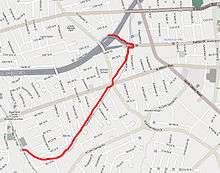
The Bluemont Junction Trail is a 1.3 miles (2.1 km) rail-trail in Arlington County, Virginia that the Arlington County government constructed along a former branch of the defunct Washington and Old Dominion Railroad. The trail travels through Bluemont Junction Park,[1] connecting Ballston with the Washington & Old Dominion Railroad Trail at Bluemont Junction near Bluemont Park.[2][3] In Ballston, the trail connects to the Custis Trail and also meets on-street bike lanes that travel to Rosslyn and Washington, D.C., via Fairfax Drive and Clarendon and Wilson Boulevards.[4]
The trail is part of a route to Georgetown and downtown Washington, D.C. It serves as an alternate to a portion of the more hilly Custis Trail.
References
- ↑ "Bluemont Junction Park". Arlington, Virginia: Arlington County Department of Parks and Recreation. Archived from the original on 2015-05-12. Retrieved 2015-08-31.
- ↑ "Bluemont Park". Arlington, Virginia: Arlington County Department of Parks and Recreation. Archived from the original on 2015-03-21. Retrieved 2015-08-31.
- ↑ Coordinates of Bluemont Junction: 38°52′19″N 77°07′56″W / 38.8718236°N 77.1321264°W
- ↑ "Arlington County Bike Map" (PDF). Bike Arlington. Department of Environmental Services, Arlington County, Virginia. Archived from the original (PDF) on 2014-11-10. Retrieved 2015-08-31.</