Blue Mountains National Park
| Blue Mountains National Park New South Wales | |
|---|---|
|
IUCN category II (national park) | |
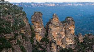 The Three Sisters, sandstone rock formations that are one of the best-known attractions in the region. | |
 Blue Mountains National Park | |
| Nearest town or city | Katoomba |
| Coordinates | 33°58′04″S 150°18′15″E / 33.96778°S 150.30417°ECoordinates: 33°58′04″S 150°18′15″E / 33.96778°S 150.30417°E |
| Established | September 1959[1] |
| Area | 2,679.54 km2 (1,034.6 sq mi)[1] |
| Visitation | 563,000 (in 2009)[2] |
| Managing authorities | NSW National Parks & Wildlife Service |
| Website | Blue Mountains National Park |
| See also |
Protected areas of New South Wales |
The Blue Mountains National Park is a protected national park that is located in the Blue Mountains region of New South Wales, in eastern Australia. The 267,954-hectare (662,130-acre) national park is situated approximately 80 kilometres (50 mi) west of Sydney, and the park boundary is quite irregular as it is broken up by roads, urban areas and inholdings.[1] Despite the name 'mountains', the area is an uplifted plateau, dissected by a number of larger rivers. The highest point in the park is Mount Werong at 1,215 metres (3,986 ft) above sea level; while the low point is on the Nepean River at 20 metres (66 ft) above sea level as it leaves the park.
The national park is one of the eight protected areas that, in 2000, was inscribed to form part of the UNESCO World Heritage–listed Greater Blue Mountains Area.[3] The Blue Mountains National Park is the most central of the eight protected areas within the World Heritage Site and it forms part of the Great Dividing Range. The park is also listed on the Australian Heritage Register and the overall complex of Blue Mountains regional walking tracks is listed on the State Heritage Register.[4]
History
-Location-Map.png)
The genesis of the national park was a proposal by early conservationist Myles Dunphy for a Greater Blue Mountains National Park in 1932. This included large areas of what are today the Blue Mountains National Park, and the Wollemi, Kanangra-Boyd, Nattai, Gardens of Stone, and Thirlmere Lakes, along with other smaller nature reserves; all managed by the NSW National Parks & Wildlife Service. In September 1959 the Blue Mountains National Park was gazetted covering 63,000 hectares (160,000 acres).[5] In 2000 it was included as part of the Greater Blue Mountains World Heritage Area. In 1999, 37 walking tracks were added to the State Heritage Register, extending from Glenbrook and the Nepean River in the east; to Mount Tomah in the north; to Wolgan Valley and Newnes in the northwest; to Jenolan Caves and Oberon in the west; and in the south, numerous walks leading down the plateau from Katoomba, Leura and Wentworth Falls.[4]
Geography
The Blue Mountains National Park lies on the eastern side of the Great Dividing Range. The plateau slopes gently down from west to east from a height of around 1,100 metres (3,600 ft) above sea level near Mount Victoria to less than 200 metres (660 ft) above sea level around Glenbrook. There are four major rivers that have most of their catchment inside the park: the Wollangambe River in the north, the Grose River in the centre, and the Coxs and Wollondilly rivers in the south. The latter two flow into Lake Burragorang, which is located just outside the park and is the site of Warragamba Dam, the major source of drinking water for Sydney. A small section of the Nepean River passes through the park. All of the major rivers flow from west to
Geology
Structurally, the Blue Mountains are part of the greater Sydney Basin. The Sydney Basin consists of layers of sedimentary rocks laid down over the past 300 million years. The Blue Mountains and Great Dividing Range were formed about 50 million years ago, when the area was uplifted.[6] More recently, volcanic flows covered large areas of the mountains in basalt. These have largely worn away, leaving only occasional outcrops on the high peaks.
Animals
There are several larger mammal species found in the park. The largest native carnivorous predator is the tiger quoll. The largest bird found in the area is the emu.
Tourism

The Blue Mountains National Park is one of the most popular national parks in Australia. The majority of tourists to the Blue Mountains see the national park from one of the many lookouts between Wentworth Falls and Blackheath, and many of these never actually set foot in the park. Activities for the visitor include short walks to lookouts above cliffs and waterfalls, overnight and longer walks to more remote areas of the park, canyoning, abseiling, rock climbing and mountain biking. A number of adventure tour companies can assist visitors in safely experiencing these activities.[6] It is also home to the world's steepest railway,[7][8] the Katoomba Scenic Railway.
The national park is renowned for the Three Sisters rock formation. Both north and south of Blackheath, the cliffs are the most spectacular as the rock faces are several hundreds metres tall.[6] In 1999, 1.045 million visits were recorded in the park.[2] Since then visitor numbers have declined to 563,000 in 2009.[2]
Southern Blue Mountains
The national park extends south as far as the Wollondilly River, west of Mittagong, New South Wales. This area was greatly affected by the construction of Warragamba Dam from 1948 to 1960. This required the flooding of the Burragorang Valley, which created Lake Burragorang and in the process cut the southern part of the Blue Mountains off from areas to the east, for example Camden, Picton and Bargo. Properties and homesteads in the southern part of the mountains were forced to close down, leaving many derelict homes and ruins. These included Bran Jan House and Kowmung House on Scotts Main Range,[9] as well as Twin Peaks, south of Yerranderie.
An exclusion zone of approximately three kilometres was created around Lake Burragorang to protect Sydney's water supply, but a through-track was allowed from Yerranderie to Belloon Pass, then further east, for the benefit of bushwalkers. This pass was later incorporated into the long-distance Katoomba to Mittagong Trail.
See also
References
- 1 2 3 "Blue Mountains National Park: Park management". Office of Environment & Heritage. Government of New South Wales. Retrieved 8 October 2014.
- 1 2 3 "Australia weighs conservation vs tourism in Blue Mountains". cnn.com. Cable News Network. 25 November 2010. Retrieved 21 May 2011.
- ↑ "Greater Blue Mountains Area". World Heritage List. UNESCO. 2014. Retrieved 31 August 2014.
- 1 2 "Blue Mountains Walking tracks". NSW State Heritage Register. Government of New South Wales. 2 April 1999. Retrieved 8 October 2014.
- ↑ "Blue Mountains National Park – History since colonisation". Office of Environment & Heritage. Government of New South Wales. Retrieved 24 April 2009.
- 1 2 3 Discover Australia's National Parks. Hema Maps. Milsons Point, New South Wales: Random House Australia. 1997. pp. 102–5. ISBN 1-875992-47-2.
- ↑ "The steepest railways on Earth". December 2014. Retrieved 30 December 2014.
- ↑ "Top five furnicular railways". December 2014. Retrieved 30 December 2014.
- ↑ Treks in New South Wales, Neil Paton (Kangaroo Press) 1986, pp. 83-84 ISBN 0-86417-079-3
External links
| Wikimedia Commons has media related to Blue Mountains, New South Wales. |
| Wikivoyage has a travel guide for Blue Mountains National Park. |
- "Blue Mountains National Park". NSW National Parks & Wildlife Service. Government of New South Wales.
- "Blue Mountains National Park". Office of Environment & Heritage. Government of New South Wales.
- "Blue Mountains National Park: Plan of management" (PDF). NSW National Parks & Wildlife Service (PDF). Government of New South Wales. 1 May 2001. ISBN 0-7313-6998-X.
- Aerial video footage of the Blue Mountains National Park (NSW, Australia) around the Jamison Valley
- Activities and Attractions in the Blue Mountains