Blue Mountains (Jamaica)
| Blue Mountains | |
|---|---|
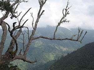 View of the Blue Mountain Range looking into St. Mary Parish from St.Andrew Parish. | |
| Highest point | |
| Peak | Blue Mountain Peak |
| Elevation | 2,256 m (7,402 ft) |
| Coordinates | 18°6′N 76°40′W / 18.100°N 76.667°WCoordinates: 18°6′N 76°40′W / 18.100°N 76.667°W |
| Geography | |
| Country | Jamaica |
| Official name | Blue and John Crow Mountains |
| Type | Mixed |
| Criteria | iii, vi, x |
| Designated | 2015 (39th session) |
| Reference no. | 1356 |
| State Party | Jamaica |
| Region | Americas |
The Blue Mountains are the longest mountain range in Jamaica. They include the island's highest point, Blue Mountain Peak, at 2256 m (7402 ft).[1] From the summit, accessible via a walking track, both the north and south coasts of the island can be seen. On a clear day, the outline of the island of Cuba, 210 km (130 mi) away, can also be seen. It spreads in 4 parishes: Portland, St.Thomas, St Mary, St.Andrew
Geography
The Blue Mountains dominate the eastern third of Jamaica, while bordering the eastern parishes of Portland, St. Thomas, St. Mary and St. Andrew to the south. Part of the Blue Mountains is contained in the Blue and John Crow Mountains National Park established in 1992, which is maintained by the Jamaican government.
The Blue Mountains rise to its elevations from the coastal plain in the space of about 16 kilometres (9.9 mi), thus producing one of the steepest general gradients in the world. This forms cooling relief from the sweltering heat of the city of Kingston, visible below. Their summits rise and fall for 24 miles and span 14 miles at their widest point. The temperature decreases from around 27°C (80°F) at sea level to 5°C (40°F) at the Blue Mountain Peak, just 16 km (9.9 mi) inland.
Rainfall
The island's average rainfall is 1,960 millimetres (77 in) per year. Where the higher elevations of the Blue Mountains catch the rain from moisture-laden winds it exceeds 5,080 millimetres (200 in) per year with some areas recording totals of more than 7,620 millimetres (300 in).
Climate data
| Climate data for Blue Mountains (altitude: 1,493 metres (4,898 ft)) | |||||||||||||
|---|---|---|---|---|---|---|---|---|---|---|---|---|---|
| Month | Jan | Feb | Mar | Apr | May | Jun | Jul | Aug | Sep | Oct | Nov | Dec | Year |
| Average high °C (°F) | 20.0 (68) |
19.9 (67.8) |
21.0 (69.8) |
21.5 (70.7) |
21.8 (71.2) |
22.9 (73.2) |
23.7 (74.7) |
23.7 (74.7) |
23.0 (73.4) |
21.9 (71.4) |
21.1 (70) |
20.4 (68.7) |
21.7 (71.1) |
| Average low °C (°F) | 11.9 (53.4) |
11.7 (53.1) |
12.0 (53.6) |
12.6 (54.7) |
13.5 (56.3) |
14.2 (57.6) |
14.7 (58.5) |
15.0 (59) |
14.4 (57.9) |
14.5 (58.1) |
14.0 (57.2) |
12.9 (55.2) |
13.5 (56.3) |
| Average precipitation mm (inches) | 126 (4.96) |
116 (4.57) |
103 (4.06) |
172 (6.77) |
219 (8.62) |
141 (5.55) |
79 (3.11) |
179 (7.05) |
226 (8.9) |
343 (13.5) |
396 (15.59) |
235 (9.25) |
2,335 (91.93) |
| Average precipitation days | 12 | 9 | 9 | 11 | 14 | 9 | 7 | 10 | 14 | 17 | 16 | 14 | 142 |
| Average relative humidity (%) (at 13:00) | 83 | 84 | 84 | 85 | 86 | 83 | 80 | 83 | 87 | 90 | 88 | 87 | 85 |
| Mean monthly sunshine hours | 127.1 | 87.6 | 145.7 | 132.0 | 124.0 | 138.0 | 155.0 | 145.7 | 129.0 | 127.1 | 126.0 | 124.0 | 1,561.2 |
| Mean daily sunshine hours | 4.1 | 3.1 | 4.7 | 4.4 | 4.0 | 4.6 | 5.0 | 4.7 | 4.3 | 4.1 | 4.2 | 4.0 | 4.3 |
| Source: Meteorological Service (Jamaica)[2] | |||||||||||||
Flora and fauna
The Blue Mountains climatic diversity has led to the growth of diverse and lush vegetation including towering trees and more than 500 species of flowering plants.
The mountains are home to the world's second-largest butterfly and the largest in the Americas, the Homerus swallowtail (Papilio homerus). The Jamaican Coney (Geocapromys brownii), a type of rodent, and the Jamaican boa (Epicrates subflavus) are also found there.
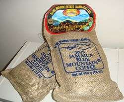
Jamaican coffee
In past years when Jamaica's economy was dominated by plantation slavery, some slaves escaped to the mountains to live independently, where they were known as Maroons. Charles Town on the Buff Bay River, Moore Town, and Scotts Hall are contemporary Maroon communities in Portland Parish.
Today, the famous Jamaican Blue Mountain Coffee, which commands premium prices on world markets, is cultivated between 2,000 and 5,000 feet above sea level,[3] while higher slopes are preserved as forest. Hagley Gap and Mavis Bank are farming communities located on Blue Mountain with Hagley Gap being closest to Blue Mountain Peak. Both towns rely upon the area's rich soil for growing coffee.
References
- ↑ Hamilton, Janice (2005), Jamaica in Pictures, Lerner Publications, p. 10, ISBN 0-8225-2394-9
- ↑ "Mean Climatological Data" (PDF). Meteorological Service (Jamaica). Retrieved 7 September 2016.
- ↑ Rebecca Tortello. "Jamaican Coffee - "A Beverage of Distinction"". A Jamaica Gleaner Feature. Retrieved 19 March 2011.
External links
| Wikivoyage has a travel guide for Blue Mountains (Jamaica). |
Geography of Jamaica | |||||||||||||||||||||||||||||||||||||||||||
|---|---|---|---|---|---|---|---|---|---|---|---|---|---|---|---|---|---|---|---|---|---|---|---|---|---|---|---|---|---|---|---|---|---|---|---|---|---|---|---|---|---|---|---|
| Subdivisions | |||||||||||||||||||||||||||||||||||||||||||
| Settlements | |||||||||||||||||||||||||||||||||||||||||||
| Landforms |
| ||||||||||||||||||||||||||||||||||||||||||
| Extreme points | |||||||||||||||||||||||||||||||||||||||||||
| Natural disasters | |||||||||||||||||||||||||||||||||||||||||||
| Fauna |
| ||||||||||||||||||||||||||||||||||||||||||
| Flora | Flora of Jamaica | ||||||||||||||||||||||||||||||||||||||||||
| Maps | |||||||||||||||||||||||||||||||||||||||||||