Bloomfield, New Jersey
| Bloomfield, New Jersey | |
|---|---|
| Township | |
| Township of Bloomfield | |
|
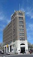
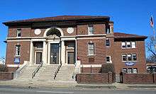
Frank M. Leo Associates Building in downtown Bloomfield | |
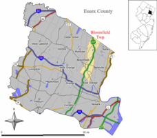 Map of Bloomfield Township in Essex County. Inset: Location of Essex County highlighted in the State of New Jersey. | |
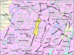 Census Bureau map of Bloomfield, New Jersey | |
| Coordinates: 40°48′33″N 74°11′14″W / 40.809128°N 74.187155°WCoordinates: 40°48′33″N 74°11′14″W / 40.809128°N 74.187155°W[1][2] | |
| Country |
|
| State |
|
| County | Essex |
| Incorporated | March 23, 1812 |
| Named for | Joseph Bloomfield |
| Government[3] | |
| • Type | Special Charter |
| • Body | Township Council |
| • Mayor | Michael J. Venezia (D, term ends December 31, 2016)[4][5] |
| • Administrator | Matthew U. Watkins[6] |
| • Clerk | Louise M. Palagano[6] |
| Area[1] | |
| • Total | 5.328 sq mi (13.801 km2) |
| • Land | 5.304 sq mi (13.738 km2) |
| • Water | 0.024 sq mi (0.063 km2) 0.46% |
| Area rank |
268th of 566 in state 7th of 22 in county[1] |
| Elevation[7] | 174 ft (53 m) |
| Population (2010 Census)[8][9][10] | |
| • Total | 47,315 |
| • Estimate (2015)[11] | 48,276 |
| • Rank |
39th of 566 in state 4th of 22 in county[12] |
| • Density | 8,920.5/sq mi (3,444.2/km2) |
| • Density rank |
40th of 566 in state 6th of 22 in county[12] |
| Time zone | Eastern (EST) (UTC-5) |
| • Summer (DST) | Eastern (EDT) (UTC-4) |
| ZIP code | 07003[13][14] |
| Area code(s) | 862/973[15] |
| FIPS code | 3401306260[1][16][17] |
| GNIS feature ID | 1729714[1][18] |
| Website |
www |
Bloomfield is a township in Essex County, New Jersey, United States. As of the 2010 United States Census, the township's population was 47,315,[8][9][10] reflecting a decline of 368 (-0.8%) from the 47,683 counted in the 2000 Census, which had in turn increased by 2,622 (+5.8%) from the 45,061 counted in the 1990 Census.[19] It surrounds the Bloomfield Green Historic District.
History
The initial patent for the land that would become Bloomfield Township was granted to the English Puritan colonists of Newark, and the area assigned to Essex County in 1675, and Newark Township in 1693. From the 1690s to about the 1720s, much of the northern and eastern land was sold to descendants of New Netherland colonists who had settled Acquackanonk, and the remainder mostly to English families. Speertown (now Upper Montclair), Stone House Plains (now Brookdale), and Second River (now Belleville) were essentially Dutch, while Cranetown, Watsessing, and the Morris Neighborhood (now North Center) were predominantly English. Starting in the mid-18th century, the English and Dutch neighborhoods gradually integrated, with Thomas Cadmus being among the first Dutchmen to settle in an English neighborhood.
Numerous residents served in the Revolutionary War.[20] No significant engagements occurred in Bloomfield, although the locale was on the Continental Army's retreat route after the Battle of Long Island; British and American troops conducted foraging operations; and General George Washington is believed to have visited at least two residences.[21] The Green was set aside to commemorate the use of that space for drilling of militia.[22]
The Presbyterian Society of Bloomfield (now the Bloomfield Presbyterian Church on the Green) was formed in 1794 in honor of then-brigadier Joseph Bloomfield, commander of New Jersey troops in the Whiskey Rebellion.[23] About the same time, the Dutch Reformed Church of Stone House Plains (now Brookdale Reformed Church) was established.[24] The two churches became integral institutions of southern and northern Bloomfield, respectively.
Bloomfield was incorporated as a township from portions of Newark Township by an act of the New Jersey Legislature on March 23, 1812.[25] At the time, the Presbyterian parish's namesake was governor of New Jersey and had recently been appointed brigadier general for service in the looming War of 1812.[26][27][28]
At the time it was incorporated, the township covered 20.52 square miles (53.1 km2) (almost four times its current area of 5.3 square miles (14 km2)) and included several municipalities which were formed from portions of Bloomfield during the course of the nineteenth century, including Belleville (created on April 8, 1839), Montclair (April 15, 1868), Woodside Township (March 24, 1869) and Glen Ridge (February 13, 1895).[25][29] The Stone House Plains neighborhood was renamed as Brookdale in 1873.[30]
In the township's first century, Brookdale farms thrived while southern Bloomfield industrialized, and the township's infrastructure, civil framework and social institutions developed. Several miles of the Morris Canal passed through Bloomfield.[31] The Oakes woollen mill thrived as a major supplier to the Union army.[32]
Bloomfield was incorporated as a town on February 26, 1900.[25] In 1981, the town was one of seven Essex County municipalities to pass a referendum to become a township, joining four municipalities that had already made the change, of what would ultimately be more than a dozen Essex County municipalities to reclassify themselves as townships in order take advantage of federal revenue sharing policies that allocated townships a greater share of government aid to municipalities on a per capita basis.[33][34][35][36][37]
In the 20th century, GE, Westinghouse and Schering built major facilities, and among others, the Charms Candy Company was started and grew.[38] After World War I, Brookdale's farms were developed into residential neighborhoods and supporting services. Substantial population growth continued into the 1950s. During World War II, while many Bloomfield men served in the armed forces, Bloomfield's farms and factories, largely staffed by women, supported the war effort. In the decades after the war, the township's industrial base steadily shut down with stricter environmental regulations, rising labor costs, and growing competition. These influences, as well as construction of the Garden State Parkway, further drove urban decay and related population turnover and stagnation through the latter part of the 20th century.
In the early 21st century, redevelopment of blighted and underutilized properties has further shifted Bloomfield towards being a primarily residential municipality.[39]
Geography
According to the United States Census Bureau, the township had a total area of 5.328 square miles (13.801 km2), including 5.304 square miles (13.738 km2) of land and 0.024 square miles (0.063 km2) of water (0.46%).[1][2]
Silver Lake (2010 total population of 4,243[40]) is an unincorporated community and census-designated place (CDP) defined by the United States Census Bureau as of the 2010 Census that is split between Belleville (with 3,769 of the CDP's residents) and Bloomfield (474 of the total).[41] Brookdale (2010 population of 9,239[42]) is a CDP located entirely within Bloomfield.[41]
Other unincorporated communities, localities and place names located partially or completely within the township include Halycon and Watsessing.[43]
Demographics
| Historical population | |||
|---|---|---|---|
| Census | Pop. | %± | |
| 1820 | 3,085 | — | |
| 1830 | 4,309 | 39.7% | |
| 1840 | 2,528 | * | −41.3% |
| 1850 | 3,385 | 33.9% | |
| 1860 | 4,790 | 41.5% | |
| 1870 | 4,580 | * | −4.4% |
| 1880 | 5,748 | 25.5% | |
| 1890 | 7,708 | 34.1% | |
| 1900 | 9,668 | * | 25.4% |
| 1910 | 15,070 | 55.9% | |
| 1920 | 22,019 | 46.1% | |
| 1930 | 38,077 | 72.9% | |
| 1940 | 41,623 | 9.3% | |
| 1950 | 49,307 | 18.5% | |
| 1960 | 51,867 | 5.2% | |
| 1970 | 52,029 | 0.3% | |
| 1980 | 47,792 | −8.1% | |
| 1990 | 45,061 | −5.7% | |
| 2000 | 47,683 | 5.8% | |
| 2010 | 47,315 | −0.8% | |
| Est. 2015 | 48,276 | [11][44] | 2.0% |
| Population sources: 1820-1920[45] 1820-1910[46] 1840[47] 1850-1870[48] 1850[49] 1870[50] 1870-1890[51] 1880-1890[52] 1890-1910[53] 1900-1930[54] 1930-1990[55] 2000[56][57] 2010[8][9][10] * = Lost territory n previous decade.[25] | |||
In comparison to the other municipalities in the U.S., the cost of living in Bloomfield was an average 20% higher than the U.S. average.[58]
According to a 2007 report from CNNMoney.com, the quality of life in Bloomfield in terms of crime are 3 incidents per 1,000 people as compared to the "best places to live average" of 1.3 incidents per 1,000. There were 35 property crime incidents per 1,000 people in Bloomfield as compared to the "best places to live average" of 20.6.[59]
2010 Census
At the 2010 United States Census, there were 47,315 people, 18,387 households, and 11,768 families residing in the township. The population density was 8,920.5 per square mile (3,444.2/km2). There were 19,470 housing units at an average density of 3,670.7 per square mile (1,417.3/km2). The racial makeup of the township was 59.61% (28,205) White, 18.51% (8,757) Black or African American, 0.41% (193) Native American, 8.22% (3,891) Asian, 0.04% (21) Pacific Islander, 9.35% (4,423) from other races, and 3.86% (1,825) from two or more races. Hispanics or Latinos of any race were 24.53% (11,606) of the population.[8]
There were 18,387 households, of which 28.3% had children under the age of 18 living with them, 44.2% were married couples living together, 14.9% had a female householder with no husband present, and 36.0% were non-families. 29.5% of all households were made up of individuals, and 9.1% had someone living alone who was 65 years of age or older. The average household size was 2.54 and the average family size was 3.20.[8]
In the township, 21.2% of the population were under the age of 18, 9.1% from 18 to 24, 30.9% from 25 to 44, 26.8% from 45 to 64, and 12.0% who were 65 years of age or older. The median age was 37.7 years. For every 100 females there were 89.6 males. For every 100 females age 18 and over, there were 86.4 males.[8]
The Census Bureau's 2006-2010 American Community Survey showed that (in 2010 inflation-adjusted dollars) median household income was $62,831 (with a margin of error of +/- $2,641) and the median family income was $77,936 (+/- $4,120). Males had a median income of $51,498 (+/- $1,805) versus $44,735 (+/- $2,867) for females. The per capita income for the township was $30,421 (+/- $1,122). About 5.8% of families and 7.4% of the population were below the poverty line, including 7.9% of those under age 18 and 7.9% of those age 65 or over.[60]
2000 Census
As of the 2000 United States Census[16] there were 47,683 people, 19,017 households, and 12,075 families residing in the township. The population density was 8,961.5 people per square mile (3,460.6/km2). There were 19,508 housing units at an average density of 3,666.3 per square mile (1,415.8/km2). The racial makeup of the township was 70.09% White, 11.69% Black, 0.19% Native American, 8.38% Asian, 0.07% Pacific Islander, 6.42% from other races, and 3.16% from two or more races. Hispanic or Latino of any race were 14.47% of the population.[56][57]
There were 19,017 households out of which 28.2% had children under the age of 18 living with them, 46.7% were married couples living together, 12.4% had a female householder with no husband present, and 36.5% were non-families. 30.4% of all households were made up of individuals and 10.6% had someone living alone who was 65 years of age or older. The average household size was 2.49 and the average family size was 3.16.[56][57]
In the township the population was spread out with 21.1% under the age of 18, 8.4% from 18 to 24, 34.0% from 25 to 44, 22.3% from 45 to 64, and 14.3% who were 65 years of age or older. The median age was 37 years. For every 100 females there were 90.8 males. For every 100 females age 18 and over, there were 87.1 males.[56][57]
The median income for a household in the township was $53,289, and the median income for a family was $64,945. Males had a median income of $43,498 versus $36,104 for females. The per capita income for the township was $26,049. About 4.4% of families and 5.9% of the population were below the poverty line, including 6.3% of those under age 18 and 8.2% of those age 65 or over.[56][57]
Parks and recreation
Brookdale Park, established in 1928, covers over 121 acres (49 ha) in Bloomfield and Montclair, making it the third-largest park in Essex County, of which 77 acres (31 ha) are in Bloomfield.[61] Watsessing Park, which is the county's fourth-largest park, covers 69.67 acres (28.19 ha) split between Bloomfield and East Orange (60 acres (24 ha) in Bloomfield), and features sections of the Second River and Toney's Brook flowing through the park.[62] Both parks are administered by the Essex County Department of Parks, Recreation, and Cultural Affairs.
The Bloomfield Parks and Recreation Department administers eight parks covering 55.23 acres (22.35 ha).[63]
Government
Local government
Bloomfield operates under a Special Charter granted under an Act of the New Jersey Legislature. The township is governed by a mayor and a six-member Township Council. The mayor and three councilmembers are elected at-large, and one member from each of three wards, with all positions chosen on a partisan basis as part of the November general election. Councilmembers are elected to three-year terms of office on a staggered basis, with the three at-large seats (and the mayoral seat) up for election together and the three ward seats coming up for election two years later.[3] Bloomfield's charter retains most of the characteristics of the Town form, with additional powers delegated to an administrator.[64]
As of 2016, the Mayor of Bloomfield is Democrat Michael J. Venezia, whose term of office ends December 31, 2016. Members of the Bloomfield Township Council are Carlos Bernard (D, 2017; Third Ward), Elias N. Chalet (D, 2017; First Ward), Wartyna "Nina" Davis (D, 2016; at-large), Nicholas Joanow (D, 2017; Second Ward), Joseph Lopez (D, 2016; at-large) and Carlos Pomares (D, 2016; at-large).[4][65][66][67][68]
Emergency services
The township maintains its own police department.[69]
The town is protected by a fire department consisting of 78 active professional firefighters who operate out of four stations 24 hours a day, 7 days a week. There is also a squad of volunteers. In 2009, the department received international accreditation.[70] The Fire Prevention Bureau is operated by the department and consists of two inspectors and two civilians.[71] The department apparatus consist of four engines, one Truck/Ladder, a rescue and three reserve apparatus.[72]
Federal, state, and county representation
Bloomfield is split between the 10th and 11th Congressional districts[73] and is part of New Jersey's 28th state legislative district.[9][74][75] Prior to the 2010 Census, Bloomfield had been part of the 8th Congressional District, a change made by the New Jersey Redistricting Commission that took effect in January 2013, based on the results of the November 2012 general elections.[76] In the redistricting that went into effect in 2013, 24,480 residents in the northern portion of the township were placed in the 10th District, while 22,835 in the southern section were placed in the 11th District.[73][77]
New Jersey's Tenth Congressional District is represented by Donald Payne Jr. (D, Newark).[78] New Jersey's Eleventh Congressional District is represented by Rodney Frelinghuysen (R, Harding Township).[79] New Jersey is represented in the United States Senate by Cory Booker (D, Newark, term ends 2021)[80] and Bob Menendez (D, Paramus, 2019).[81][82]
For the 2016–2017 session (Senate, General Assembly), the 28th Legislative District of the New Jersey Legislature is represented in the State Senate by Ronald Rice (D, Newark) and in the General Assembly by Ralph R. Caputo (D, Nutley) and Cleopatra Tucker (D, Newark).[83] The Governor of New Jersey is Chris Christie (R, Mendham Township).[84] The Lieutenant Governor of New Jersey is Kim Guadagno (R, Monmouth Beach).[85]
Essex County is governed by a directly-elected County Executive, with legislative functions performed by the Board of Chosen Freeholders.[86] As of 2014, the County Executive is Joseph N. DiVincenzo, Jr.[87] The county's Board of Chosen Freeholders consists of nine members, four elected on an at-large basis and one from each of five wards, who serve three-year terms of office on a concurrent basis, all of which end December 31, 2014.[86][88][89] Essex County's Freeholders are Freeholder President Blonnie R. Watson (at large; Newark),[90] Freeholder Vice President Patricia Sebold (at large; Livingston),[91] Rufus I. Johnson (at large; Newark),[92] Gerald W. Owens (At large; South Orange, filling the vacant seat after the resignation of Donald Payne, Jr.)[93] Rolando Bobadilla (District 1 - Newark's North and East Wards, parts of Central and West Wards; Newark),[94] D. Bilal Beasley (District 2 - Irvington, Maplewood and Newark's South Ward and parts of West Ward; Irvington),[95] Carol Y. Clark (District 3 - East Orange, Newark's West and Central Wards, Orange and South Orange; East Orange)[96] and Leonard M. Luciano (District 4 - Caldwell, Cedar Grove, Essex Fells, Fairfield, Livingston, Millburn, North Caldwell, Roseland, Verona, West Caldwell and West Orange; West Caldwell),[97] and Brendan W. Gill (District 5 - Belleville, Bloomfield, Glen Ridge, Montclair and Nutley; Montclair).[98][99][100] Constitutional elected countywide are County Clerk Christopher J. Durkin (West Caldwell, 2015),[101] Sheriff Armando B. Fontoura (2015)[102] and Surrogate Theodore N. Stephens, II (2016).[103][88][104]
Politics
As of March 23, 2011, there were a total of 28,398 registered voters in Bloomfield, of which 11,925 (42.0%) were registered as Democrats, 4,393 (15.5%) were registered as Republicans and 12,061 (42.5%) were registered as Unaffiliated. There were 19 voters registered to other parties.[105]
In the 2012 presidential election, Democrat Barack Obama received 69.9% of the vote (13,361 cast), ahead of Republican Mitt Romney with 28.8% (5,501 votes), and other candidates with 1.3% (245 votes), among the 19,242 ballots cast by the township's 29,923 registered voters (135 ballots were spoiled), for a turnout of 64.3%.[106][107] In the 2008 presidential election, Democrat Barack Obama received 62.9% of the vote here (12,735 cast), ahead of Republican John McCain with 35.3% (7,154 votes) and other candidates with 0.9% (186 votes), among the 20,251 ballots cast by the township's 27,981 registered voters, for a turnout of 72.4%.[108] In the 2004 presidential election, Democrat John Kerry received 57.0% of the vote here (10,829 ballots cast), outpolling Republican George W. Bush with 41.5% (7,891 votes) and other candidates with 0.7% (208 votes), among the 19,012 ballots cast by the township's 27,995 registered voters, for a turnout percentage of 67.9.[109]
In the 2013 gubernatorial election, Democrat Barbara Buono received 53.1% of the vote (5,808 cast), ahead of Republican Chris Christie with 45.6% (4,984 votes), and other candidates with 1.3% (141 votes), among the 11,118 ballots cast by the township's 30,606 registered voters (185 ballots were spoiled), for a turnout of 36.3%.[110][111] In the 2009 gubernatorial election, Democrat Jon Corzine received 53.8% of the vote here (6,241 ballots cast), ahead of Republican Chris Christie with 37.6% (4,359 votes), Independent Chris Daggett with 6.6% (761 votes) and other candidates with 1.3% (147 votes), among the 11,599 ballots cast by the township's 27,929 registered voters, yielding a 41.5% turnout.[112]
Education
Primary and secondary schools
Public schools
The Bloomfield Public Schools serve students in pre-Kindergarten through twelfth grade. As of the 2011-12 school year, the district's 11 schools had an enrollment of 6,059 students and 503.6 classroom teachers (on an FTE basis), for a student–teacher ratio of 12.03:1.[113] Schools in the district (with 2011-12 enrollment data from the National Center for Education Statistics[114]) are eight elementary schools serving Kindergarten through sixth grade — Berkeley School[115] (402 students) Brookdale School[116] (NA), Carteret School[117] (428), Demarest School[118] (484), Fairview School[119] (520), Franklin School[120] (396), Oak View School[121] (357), Watsessing School[122] (311) — Bloomfield Middle School[123] for grades 7 and 8 (917), and Bloomfield High School[124] for grades 9-12 (1,852), while Bridges Academy at Forest Glen[125] provides individualized programs and services to special needs students in grades 7-12 (37 students).[126][127]
As of the 2012-13 school year, the Bloomfield Public Schools had an actual Budgetary Per Pupil Cost of $11,848 (which is 16.4% below the statewide group average was $14,173), while Total Spending Per Pupil for the district was $15,848 (which is 16.0% below the $18,867 statewide).[128][129]
Bloomfield Tech High School is a regional magnet public high school that offers occupational and academic instruction for students in Essex County, as part of the Essex County Vocational Technical Schools.[130]
Catholic schools
Saint Thomas the Apostle Parish School, which serves grades K-8, is operated under the supervision of the Roman Catholic Archdiocese of Newark.[131][132]
Colleges and universities
Bloomfield College, a liberal arts college founded in 1868, is located in downtown Bloomfield near the town green. The college has approximately 2,000 students and is affiliated with the Presbyterian Church.[133]
Transportation
Roads and highways
As of May 2010, the township had a total of 95.39 miles (153.52 km) of roadways, of which 77.39 miles (124.55 km) were maintained by the municipality, 13.77 miles (22.16 km) by Essex County and 4.23 miles (6.81 km) by the New Jersey Turnpike Authority.[134]
The major New Jersey highway artery that serves Bloomfield is the Garden State Parkway, the longest road in the state.[135] It has four interchanges in the township. Interchanges 148 in the south of Bloomfield and 151 in the north are complete interchanges, while 149 and 150 are partials. The Parkway's Essex toll plaza is southbound just south of interchange 150 in the township. There are two service areas on the Parkway in Bloomfield, one for northbound and one southbound.[136] Troop E of the New Jersey State Police, which patrols the full length of the Garden State Parkway, has a station in Bloomfield at northbound milepost 153.[137]
County Road 506, 506 Spur and 509 serve Bloomfield.
Commuter rail
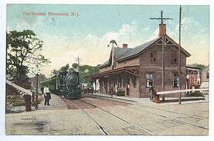
South Bloomfield is served by two stations of the NJ Transit Montclair-Boonton Line to Hoboken Terminal or to Penn Station in Midtown Manhattan via the Secaucus Junction.[138] About 55% of the weekday trains terminate in Penn Station via Midtown Direct. On weekends the line terminates in Hoboken. The Bloomfield train station is located off of Bloomfield Avenue in the downtown area.[139] The Watsessing Avenue rail station is at the corner of Watsessing Avenue and Orange Street, and is located below ground.[140]
Bloomfield used to be served by other passenger rail lines. The Rowe Street Station was served by the Boonton Line until September 2002, when it was closed as part of the addition of Midtown Direct service to the township.[141] The Walnut Street station, on the same line, was closed in 1953 when the Garden State Parkway was built through it.
Light rail
The Grove Street station on the Newark City Subway line of the Newark Light Rail at the south end of Bloomfield provides service to Newark Penn Station, created as part of an extension to Belleville and Bloomfield that opened in 2002.[142] This station was part of the Orange Branch of the New York & Greenwood Lake Service of the Erie Railroad with service to Jersey City which last saw service in 1955.
Buses
NJ Transit bus service is available to and from Newark on the 11, 27, 28, 29, 34, 72, 90, 92, 93 and 94 routes, with local service on the 709 bus line.[143] In October 2009, the Go Bus 28 route was introduced, offering service nearly all day from Bloomfield Train Station to Newark Liberty International Airport.[144][145]
Airports
Bloomfield is 7.5 miles (12.1 km) from Newark Liberty International Airport in Newark / Elizabeth, and 28.8 miles (46.3 km) from LaGuardia Airport in Flushing, Queens.
Points of interest
- Glendale Cemetery
- Holsten's Brookdale Confectionery, filming location of the final scene in the final episode of The Sopranos.[146]
- The Oakes Estate, constructed in 1895 based on a design by Charles Granville Jones, was added to the National Register of Historic Places in 1981.[147]
Notable events
- In 1942, the Westinghouse Lamp Plant in Bloomfield produced the majority of uranium metal used in the Chicago Pile-1, the world's first self-sustaining chain reaction which was the early phase of the Manhattan Project to create the first atomic bomb.[148]
Notable people
People who were born in, residents of, or otherwise closely associated with Bloomfield include:
- Alaa Abdelnaby (born 1968), former NBA basketball player.[149]
- James Avati (1912-2005), illustrator and paperback cover artist.[150]
- Caleb Cook Baldwin (1820-1911), one of the first Presbyterian missionaries to Fuzhou (then Foochow), China.[151]
- Arthur Hornbui Bell (1891-1973), Ku Klux Klan leader in New Jersey in the 1920s.[152]
- Seth Bingham (1882-1972), organist and prolific composer.[153]
- William D. Bishop (1827-1904), member of the United States House of Representatives from Connecticut's 4th congressional district from 1857 to 1859.[154]
- Hank Borowy (1916-2004), Major League Baseball All-Star pitcher who played for the New York Yankees, Chicago Cubs, Philadelphia Phillies, Pittsburgh Pirates and Detroit Tigers.[155]
- Randolph Bourne (1886-1918), radical writer and opponent of U.S. involvement in World War I.[156]
- William Batchelder Bradbury (1816–1868), composer of the tune to Jesus Loves Me and many other popular hymns.
- Doug Brien (born 1970), placekicker who played for the New York Jets and six other teams in his 12-season NFL career.[157]
- Kevin Burkhardt (born 1974), sportscaster. Currently one of the play-by-play voices for the NFL on FOX and a reporter with SportsNet New York, who is the field reporter during New York Mets telecasts.[158]
- Thomas Cadmus (1736-1821), businessman, Revolutionary War officer and community leader.
- Marco Capozzoli (born 1988), placekicker who has played in the Arena Football League for the Jacksonville Sharks.[159]
- Roger Cook (born 1930), graphic designer, photographer and artist.[160][161]
- Marion Crecco (1930-2015), member of the New Jersey General Assembly from 1986 to 2002.[162]
- Tom Cudworth (born 1964), screenwriter.[163]
- Peter David (born 1956), science fiction and fantasy author known for his work in comic books and Star Trek novels.[164][165]
- Frank Howard Dodd (1844-1916), publisher.[166]
- Lt. Col. Robert Eden (1836-1907), a grandson of the 1st Lord Henley, fought in the American Civil War with the 37th Wisconsin Volunteers, was editor of the Northwestern newspaper, and became senior engineer with the Edison Light Co.[167]
- Charles Warren Eaton (1857-1937), artist best known for his tonalist landscapes who lived in Bloomfield from 1888 until his death in 1937.[168]
- Todd Edwards (born 1972), house music and UK Garage producer, an early pioneer of the genre of UK Garage.[169]
- Tom Fleming (born 1951), long distance runner and two-time winner of the New York City Marathon.[170]
- Connie Francis (born 1938), singer.[171]
- Bill Geyer (1919-2004), halfback who played for three seasons for the Chicago Bears.[172]
- Johnny Gibson (1905-2006), Olympic runner.[173]
- Roger Lee Hall (born 1942), composer and musicologist.[174]
- Merton Hanks (born 1968), former NFL safety who played for the San Francisco 49ers and has been the NFL's Vice President of Operations.[175]
- Ted Leo (born 1970), punk rock singer, songwriter and guitarist.[176]
- Bob Ley (born 1955), ESPN sportscaster.[177]
- R. Stevie Moore (born 1952), lo-fi singer/songwriter.[178]
- Charles A. Morris (1853-1914), engineer and dredging inventor.[179]
- Mark Sceurman, graphic artist who is co-creator and publisher of Weird NJ magazine.[180]
- Frank Tripucka (1927-2013), pro football Denver Bronco's quarterback. Owned Trip Distribution, Inc.[181]
- Kelly Tripucka (born 1959), pro basketball player for several teams, including the New Jersey Nets and New York Knicks.[182] The Tripuckas are father and son, and both played their sports at the University of Notre Dame.
- Alexander Wilson (1766-1813), the Father of American Ornithology, lived in Bloomfield for several months in 1801, where he was employed as a schoolteacher.[183]
- Dick Zimmer (born 1944), former member of the United States House of Representatives, Republican candidate for United States Senate in 1996 and 2008.[184]
References
- 1 2 3 4 5 6 2010 Census Gazetteer Files: New Jersey County Subdivisions, United States Census Bureau. Accessed May 21, 2015.
- 1 2 US Gazetteer files: 2010, 2000, and 1990, United States Census Bureau. Accessed September 4, 2014.
- 1 2 2012 New Jersey Legislative District Data Book, Rutgers University Edward J. Bloustein School of Planning and Public Policy, March 2013, p. 128.
- 1 2 Officials, Township of Bloomfield. Accessed July 1, 2016.
- ↑ 2016 New Jersey Mayors Directory, New Jersey Department of Community Affairs. Accessed June 14, 2016.
- 1 2 Administration, Township of Bloomfield. Accessed July 1, 2016.
- ↑ U.S. Geological Survey Geographic Names Information System: Township of Bloomfield, Geographic Names Information System. Accessed March 4, 2013.
- 1 2 3 4 5 6 DP-1 - Profile of General Population and Housing Characteristics: 2010 for Bloomfield township, Essex County, New Jersey, United States Census Bureau. Accessed January 28, 2012.
- 1 2 3 4 Municipalities Grouped by 2011-2020 Legislative Districts, New Jersey Department of State, p. 13. Accessed January 6, 2013.
- 1 2 3 Table DP-1. Profile of General Demographic Characteristics: 2010 for Bloomfield township, Essex County, New Jersey, New Jersey Department of Labor and Workforce Development. Accessed January 28, 2012.
- 1 2 PEPANNRES - Annual Estimates of the Resident Population: April 1, 2010 to July 1, 2015 - 2015 Population Estimates for New Jersey municipalities, United States Census Bureau. Accessed May 22, 2016.
- 1 2 GCT-PH1 Population, Housing Units, Area, and Density: 2010 - State -- County Subdivision from the 2010 Census Summary File 1 for New Jersey, United States Census Bureau. Accessed December 11, 2012.
- ↑ Look Up a ZIP Code for Bloomfield, NJ, United States Postal Service. Accessed November 7, 2011.
- ↑ Zip Codes, State of New Jersey. Accessed August 26, 2013.
- ↑ Area Code Lookup - NPA NXX for Bloomfield, NJ, Area-Codes.com. Accessed September 16, 2013.
- 1 2 American FactFinder, United States Census Bureau. Accessed September 4, 2014.
- ↑ A Cure for the Common Codes: New Jersey, Missouri Census Data Center. Accessed September 29, 2012.
- ↑ US Board on Geographic Names, United States Geological Survey. Accessed September 4, 2014.
- ↑ Table 7. Population for the Counties and Municipalities in New Jersey: 1990, 2000 and 2010, New Jersey Department of Labor and Workforce Development, February 2011. Accessed September 29, 2012.
- ↑ https://archive.org/stream/bloomfieldoldnew01fols#page/n49/mode/2up Folsom, Joseph F., Bloomfield, old and new: an historical symposium
- ↑ https://archive.org/stream/bloomfieldoldnew01fols#page/32/mode/2up Folsom, Joseph F., Bloomfield, old and new: an historical symposium
- ↑ https://archive.org/stream/bloomfieldoldnew01fols#page/54/mode/2up Folsom, Joseph F., Bloomfield, old and new: an historical symposium
- ↑ Charles Eugene Knox, Origin and Annals of the "Old Church on the Green"
- ↑ Folsom, Joseph F., Bloomfield, old and new: an historical symposium
- 1 2 3 4 Snyder, John P. The Story of New Jersey's Civil Boundaries: 1606-1968, Bureau of Geology and Topography; Trenton, New Jersey; 1969. p. 126. Accessed January 28, 2012.
- ↑ Bloomfield, New Jersey - A Brief History, First Baptist Church of Bloomfield, NJ. Accessed August 21, 2007.
- ↑ Gannett, Henry. The Origin of Certain Place Names in the United States, p. 49. United States Government Printing Office, 1905. Accessed August 27, 2015.
- ↑ Hutchinson, Viola L. The Origin of New Jersey Place Names, New Jersey Public Library Commission, May 1945. Accessed August 27, 2015.
- ↑ A Brief History of Bloomfield , Township of Bloomfield, December 8, 2014. Accessed June 16, 2006.
- ↑ Folsom, Joseph F., Bloomfield, old and new : an historical symposium
- ↑ http://canalsocietynj.org/Mcanal_map.htm
- ↑ THE OAKES TEXTILE MILL
- ↑ "Chapter VI: Municipal Names and Municipal Classification", p. 73. New Jersey State Commission on County and Municipal Government, 1992. Accessed September 24, 2015.
- ↑ "Removing Tiering From The Revenue Sharing Formula Would Eliminate Payment Inequities To Local Governments", Government Accountability Office, April 15, 1982. Accessed September 24, 2015. "In 1978, South Orange Village was the first municipality to change its name to the 'township' of South Orange Village effective beginning in entitlement period 10 (October 1978 to September 1979). The Borough of Fairfield in 1978 changed its designation by a majority vote of the electorate and became the 'Township of Fairfield' effective beginning entitlement period 11 (October 1979 to September 1980).... However, the Revenue Sharing Act was not changed and the actions taken by South Orange and Fairfield prompted the Town of Montclair and West Orange to change their designation by referendum in the November 4, 1980, election. The municipalities of Belleville, Verona, Bloomfield, Nutley, Essex Fells, Caldwell, and West Caldwell have since changed their classification from municipality to a township."
- ↑ Narvaez, Alfonso A. "New Jersey Journal", The New York Times, December 27, 1981. Accessed September 24, 2015. "Under the Federal system, New Jersey's portion of the revenue sharing funds is disbursed among the 21 counties to create three 'money pools.' One is for county governments, one for 'places' and a third for townships. By making the change, a community can use the 'township advantage' to get away from the category containing areas with low per capita incomes."
- ↑ Karcher, Alan J. New Jersey's Multiple Municipal Madness, pp. 119-120. Rutgers University Press, 1998. ISBN 9780813525662. Accessed September 24, 2015.
- ↑ Bloomfield, New Jersey - A Brief History, First Baptist Church of Bloomfield. Accessed July 6, 2007. "In July of 1981, by a special election, it changed its designation to 'Township' again."
- ↑ A Brief History of Bloomfield
- ↑ Former GE Plant–Turned–Housing Revives Run-down NJ Neighborhood
- ↑ DP-1 - Profile of General Population and Housing Characteristics: 2010 Demographic Profile Data for Silver Lake - Essex CDP, New Jersey, United States Census Bureau. Accessed November 4, 2012.
- 1 2 New Jersey: 2010 - Population and Housing Unit Counts - 2010 Census of Population and Housing (CPH-2-32), United States Census Bureau, August 2012, p. III-3. Accessed November 4, 2012. "Silver Lake (formed from parts of deleted whole-township Belleville and Bloomfield CDPs)"
- ↑ DP-1 - Profile of General Population and Housing Characteristics: 2010 Demographic Profile Data for Brookdale CDP, New Jersey, United States Census Bureau. Accessed November 4, 2012.
- ↑ Locality Search, State of New Jersey. Accessed May 22, 2015.
- ↑ Census Estimates for New Jersey April 1, 2010 to July 1, 2015, United States Census Bureau. Accessed May 22, 2016.
- ↑ Compendium of censuses 1726-1905: together with the tabulated returns of 1905, New Jersey Department of State, 1906. Accessed July 25, 2013.
- ↑ Folsom, Joseph Fulford. Bloomfield, Old and New: An Historical Symposium, p. 145. Centennial Historical Committee, 1912. Accessed November 4, 2012.
- ↑ Bowen, Francis. American Almanac and Repository of Useful Knowledge for the Year 1843, p. 231, David H. Williams, 1842. Accessed July 25, 2013.
- ↑ Raum, John O. The History of New Jersey: From Its Earliest Settlement to the Present Time, Volume 1, p. 241, J. E. Potter and company, 1877. Accessed July 25, 2013. "Bloomfield township is five miles long by three wide, On its north is Acqackannonck, Passaic county, Belleville and the city of Newark on the east, Orange on the south, and Montclair and Orange on the west. On the Second and Third rivers, there are numerous manufacturing establishments. The population in 1850 was 3,385; in 1860, 4,790; and in 1870, 4,580. The village of the same name extends about three and a half miles in a northwesterly direction, including West Bloomfield. It was settled in the early part of the colony by New Englanders."
- ↑ Debow, James Dunwoody Brownson. The Seventh Census of the United States: 1850, p. 138. R. Armstrong, 1853. Accessed July 25, 2013.
- ↑ Staff. A compendium of the ninth census, 1870, p. 259. United States Census Bureau, 1872. Accessed July 25, 2013.
- ↑ Salisbury, Rollin D. The Physical Geography of New Jersey: Volume IV. of the Final Report of the State Geologist, p. 157. Trenton, New Jersey, The John L. Murphy Publishing Company, 1898. Accessed November 4, 2012.
- ↑ Porter, Robert Percival. Preliminary Results as Contained in the Eleventh Census Bulletins: Volume III - 51 to 75, p. 97. United States Census Bureau, 1890. Accessed July 25, 2013.
- ↑ Thirteenth Census of the United States, 1910: Population by Counties and Minor Civil Divisions, 1910, 1900, 1890, United States Census Bureau, p. 336. Accessed September 29, 2012.
- ↑ Fifteenth Census of the United States : 1930 - Population Volume I, United States Census Bureau, p. 710. Accessed January 28, 2012.
- ↑ New Jersey Resident Population by Municipality: 1930 - 1990, Workforce New Jersey Public Information Network. Accessed June 28, 2015.
- 1 2 3 4 5 Census 2000 Profiles of Demographic / Social / Economic / Housing Characteristics for Bloomfield township, New Jersey, United States Census Bureau. Accessed September 29, 2012.
- 1 2 3 4 5 DP-1: Profile of General Demographic Characteristics: 2000 - Census 2000 Summary File 1 (SF 1) 100-Percent Data for Bloomfield township, Essex County, New Jersey, United States Census Bureau. Accessed September 29, 2012.
- ↑ Cost of Living in Bloomfield (ZIP 07003), New Jersey, Sperling's BestPlaces. Accessed December 22, 2014.
- ↑ "MONEY Magazine: Best places to live 2007: Bloomfield, NJ snapshot", CNNMoney, backed up by the Internet Archive as of August 13, 2007. Accessed December 22, 2014.
- ↑ DP03: Selected Economic Characteristics from the 2006-2010 American Community Survey 5-Year Estimates for Bloomfield township, Essex County, New Jersey, United States Census Bureau. Accessed January 28, 2012.
- ↑ Brookdale Park, Essex County Department of Parks, Recreation, and Cultural Affairs. Accessed November 4, 2012.
- ↑ Watsessing Park, Essex County Department of Parks, Recreation, and Cultural Affairs. Accessed November 4, 2012.
- ↑ Bloomfield Parks & Recreation Facilities, Township of Bloomfield. Accessed July 22, 2014.
- ↑ "Chapter V: Special Charters", New Jersey State Library. Accessed June 25, 2015.
- ↑ 2016 Municipal User Friendly Budget, Township of Bloomfield. Accessed July 1, 2016.
- ↑ County Directory, Essex County, New Jersey. Accessed July 1, 2016.
- ↑ 2015 General Election Results November 4, 2014, Essex County, New Jersey Clerk, updated April 18, 2016. Accessed July 1, 2016.
- ↑ 2013 General Election Results November 5, 2013, Essex County, New Jersey Clerk, updated April 15, 2016. Accessed July 1, 2016.
- ↑ Home Page, Bloomfield Police Department. Accessed July 1, 2016.
- ↑ Accreditation, Township of Bloomfield. Accessed November 20, 2016.
- ↑ John H. "Jack" Flaherty Fire Prevention Bureau, Township of Bloomfield. Accessed November 20, 2016.
- ↑ Fire Suppression, Township of Bloomfield. Accessed November 20, 2016.
- 1 2 Plan Components Report, New Jersey Redistricting Commission, December 23, 2011. Accessed January 6, 2013.
- ↑ 2016 New Jersey Citizen's Guide to Government, p. 55, New Jersey League of Women Voters. Accessed July 20, 2016.
- ↑ Districts by Number for 2011-2020, New Jersey Legislature. Accessed January 6, 2013.
- ↑ 2011 New Jersey Citizen's Guide to Government, p. 55, New Jersey League of Women Voters. Accessed May 22, 2015.
- ↑ New Jersey Congressional Districts 2012-2012: Bloomfield Map, New Jersey Department of State. Accessed January 6, 2013.
- ↑ Directory of Representatives: New Jersey, United States House of Representatives. Accessed January 5, 2012.
- ↑ Directory of Representatives: New Jersey, United States House of Representatives. Accessed January 5, 2012.
- ↑ About Cory Booker, United States Senate. Accessed January 26, 2015. "He now owns a home and lives in Newark's Central Ward community."
- ↑ Biography of Bob Menendez, United States Senate, January 26, 2015. "He currently lives in Paramus and has two children, Alicia and Robert."
- ↑ Senators of the 114th Congress from New Jersey. United States Senate. Accessed January 26, 2015. "Booker, Cory A. - (D - NJ) Class II; Menendez, Robert - (D - NJ) Class I"
- ↑ Legislative Roster 2016-2017 Session, New Jersey Legislature. Accessed January 17, 2016.
- ↑ "About the Governor". State of New Jersey. Retrieved 2010-01-21.
- ↑ "About the Lieutenant Governor". State of New Jersey. Retrieved 2010-01-21.
- 1 2 General Information, Essex County, New Jersey. Accessed July 9, 2014. "The Board of Chosen Freeholders consists of nine members, five of whom are elected from districts and four of whom are elected at-large. They are elected for three-year concurrent terms and may be re-elected to successive terms at the annual election in November."
- ↑ Essex County Executive, Essex County, New Jersey. Accessed July 9, 2014.
- 1 2 Essex County Elected Officials, Essex County Clerk, as of February 2012. Accessed July 9, 2014.
- ↑ Definition of a Freeholder, Essex County, New Jersey. Accessed July 9, 2014.
- ↑ Blonnie R. Watson, Essex County, New Jersey. Accessed July 9, 2014.
- ↑ Patricia Sebold, Essex County, New Jersey. Accessed July 9, 2014.
- ↑ Rufus I. Johnson, Essex County, New Jersey. Accessed July 9, 2014.
- ↑ Lee, Eunice. "Labor leader from South Orange tapped as new Essex County freeholder", The Star-Ledger, December 19, 2012. Accessed July 9, 2014. "A longtime labor union leader from South Orange was sworn in this afternoon as the newest Essex County freeholder.Gerald Owens, 74, is a general organizer for the International Longshoremen's Association.... Owens is filling the seat vacated by former at-large freeholder Donald Payne Jr., who stepped down from the post last month after securing the 10th Congressional District seat left open by his late father."
- ↑ Rolando Bobadilla, Essex County, New Jersey. Accessed July 9, 2014.
- ↑ D. Bilal Beasley, Essex County, New Jersey. Accessed July 9, 2014.
- ↑ Carol Y. Clark, Essex County, New Jersey. Accessed July 9, 2014.
- ↑ Leonard M. Luciano, Essex County, New Jersey. Accessed July 9, 2014.
- ↑ Brendan W. Gill, Essex County, New Jersey. Accessed July 9, 2014.
- ↑ The Board of Chosen Freeholders, Essex County, New Jersey. Accessed July 9, 2014.
- ↑ Breakdown of Freeholder Districts, Essex County, New Jersey. Accessed July 9, 2014.
- ↑ About Christopher J. Durkin, Essex County Clerk. Accessed July 9, 2014.
- ↑ Armando B. Fontoura - Essex County Sheriff, Essex County Sheriff's Office. Accessed July 9, 2014.
- ↑ Office of Surrogate, Essex County, New Jersey. Accessed July 9, 2014.
- ↑ County Directory, Essex County, New Jersey. Accessed July 9, 2014.
- ↑ Voter Registration Summary - Essex, New Jersey Department of State Division of Elections, March 23, 2011. Accessed November 5, 2012.
- ↑ "Presidential General Election Results - November 6, 2012 - Essex County" (PDF). New Jersey Department of Elections. March 15, 2013. Retrieved December 24, 2014.
- ↑ "Number of Registered Voters and Ballots Cast - November 6, 2012 - General Election Results - Essex County" (PDF). New Jersey Department of Elections. March 15, 2013. Retrieved December 24, 2014.
- ↑ 2008 Presidential General Election Results: Essex County, New Jersey Department of State Division of Elections, December 23, 2008. Accessed November 5, 2012.
- ↑ 2004 Presidential Election: Essex County, New Jersey Department of State Division of Elections, December 13, 2004. Accessed November 5, 2012.
- ↑ "Governor - Essex County" (PDF). New Jersey Department of Elections. January 29, 2014. Retrieved December 24, 2014.
- ↑ "Number of Registered Voters and Ballots Cast - November 5, 2013 - General Election Results - Essex County" (PDF). New Jersey Department of Elections. January 29, 2014. Retrieved December 24, 2014.
- ↑ 2009 Governor: Essex County, New Jersey Department of State Division of Elections, December 31, 2009. Accessed November 5, 2012.
- ↑ District information for Bloomfield School District, National Center for Education Statistics. Accessed July 22, 2014.
- ↑ School Data for the Bloomfield Public Schools, National Center for Education Statistics. Accessed July 22, 2014.
- ↑ Berkeley School, Bloomfield Public Schools. Accessed August 26, 2013.
- ↑ Brookdale School, Bloomfield Public Schools. Accessed August 26, 2013.
- ↑ Carteret School, Bloomfield Public Schools. Accessed August 26, 2013.
- ↑ Demarest School, Bloomfield Public Schools. Accessed August 26, 2013.
- ↑ Fairview School, Bloomfield Public Schools. Accessed August 26, 2013.
- ↑ Franklin School, Bloomfield Public Schools. Accessed August 26, 2013.
- ↑ Oak View School, Bloomfield Public Schools. Accessed August 26, 2013.
- ↑ Watsessing School, Bloomfield Public Schools. Accessed August 26, 2013.
- ↑ Bloomfield Middle School, Bloomfield Public Schools. Accessed August 26, 2013.
- ↑ Bloomfield High School, Bloomfield Public Schools. Accessed August 26, 2013.
- ↑ Bridges Academy at Forest Glen, Bloomfield Public Schools. Accessed August 26, 2013.
- ↑ Schools, Bloomfield Public Schools. Accessed August 26, 2013.
- ↑ New Jersey School Directory for the Bloomfield Public Schools, New Jersey Department of Education. Accessed August 25, 2013.
- ↑ Taxpayers' Guide to Education Spending 2013 for Bloomfield Twp (0410), New Jersey Department of Education. Accessed July 22, 2014.
- ↑ Taxpayers' Guide to Education Spending 2013 for Enrollment Group: G. K-12 / 3501 +, New Jersey Department of Education. Accessed July 22, 2014.
- ↑ About Us, Bloomfield Tech High School. Accessed November 20, 2016.
- ↑ About Us, Saint Thomas the Apostle Parish School. Accessed July 25, 2013.
- ↑ Essex County Catholic Elementary Schools, Roman Catholic Archdiocese of Newark. Accessed July 22, 2014.
- ↑ About Us, Bloomfield College. Accessed November 20, 2016. "Bloomfield College is an independent, four-year, coeducational college, affiliated with Presbyterian Church (USA), founded in 1868.... Enrollment: About 2,000 students are enrolled at Bloomfield College either full or part time, with more than 50 nationalities represented on campus."
- ↑ Essex County Mileage by Municipality and Jurisdiction, New Jersey Department of Transportation, May 2010. Accessed July 18, 2014.
- ↑ Garden State Parkway Straight Line Diagram, New Jersey Department of Transportation, January 1997. Accessed July 22, 2014.
- ↑ Travel Resources: Interchanges, Service Areas & Commuter Lots, New Jersey Turnpike Authority. Accessed July 22, 2014.
- ↑ Troop E Archived October 20, 2012, at the Wayback Machine., New Jersey State Police. Accessed July 18, 2011.
- ↑ Montclair-Boonton Line, NJ Transit. Accessed July 22, 2014.
- ↑ Bloomfield station, NJ Transit. Accessed July 22, 2014.
- ↑ Watsessing Avenue station, NJ Transit. Accessed July 22, 2014.
- ↑ "RAIL SHUTTLE BUSES TO TRANSPORT COMMUTERS AFFECTED BY STATION CLOSURES; NJ TRANSIT Buses and Trains Will Cross-Honor September Monthly Train Passes For Rowe Street Customers", NJ Transit, August 27, 2002. Accessed July 22, 2014. "On Monday, September 30, NJ TRANSIT will launch its MidTOWN DIRECT -- Montclair rail service, resulting in the closure of Benson Street, Rowe Street and Arlington stations on the Boonton Line after the last scheduled trip on Friday, September 20."
- ↑ Staff. "Subway extension to open in summer, Newark officials hope that the $207.7 million downtown project will help spur a renaissance.", The Philadelphia Inquirer, February 13, 2006. Accessed July 18, 2011. "The last major expansion of the 4.3mile subway in 2002 brought the service into the neighboring cities of Belleville and Bloomfield."
- ↑ Essex County Bus/Rail Connections, NJ Transit, backed up by the Internet Archive as of May 22, 2009. Accessed July 18, 2011.
- ↑ NJ TRANSIT UNVEILS NEW 'GO BUS 28' SERVICE IN NEWARK AND BLOOMFIELD; Enhanced bus service begins October 17, linking residents with major employment centers, NJ Transit press release dated October 16, 2009. Accessed July 18, 2011. "NJ TRANSIT and local officials today previewed the second phase of 'Go Bus' service—an enhanced bus service that will provide a faster, more convenient trip between Bloomfield, downtown Newark and Newark Liberty International Airport when Go Bus 28 begins operating Saturday, October 17."
- ↑ Go Bus 28 (Bloomfield - Newark - Newark Airport), NJ Transit. Accessed July 18, 2011. "Go bus 28 provides fast, convenient service along two of northern New Jersey's busiest corridors between the cities of Bloomfield and Newark, Bloomfield Avenue and Broad Street."
- ↑ Caldwell, Dave. "Ice Cream, Onion Rings and Tony Soprano", The New York Times, August 26, 2007. Accessed November 4, 2012. "Holsten's is the site of the last scene of the 86th and final episode of The Sopranos. Tony Soprano, the fictitious mob boss, meets his family there for dinner. Then, as strangers lurk in the background, the screen goes black."
- ↑ History, Oakside Bloomfield Cultural Center. Accessed November 20, 2016.
- ↑ Walsh, John (19 June 1981). "A Manhattan Project Postscript" (PDF). Science. AAAS. 212 (4501): 1369–1371. doi:10.1126/science.212.4501.1369. ISSN 0036-8075. PMID 17746246. Retrieved 6 March 2014.
- ↑ Bonk, Thomas. "NCAA BASKETBALL TOURNAMENT Duke's Abdelnaby Is Driven Blue Devils: After three inconsistent seasons and some off-court difficulties, the center has finally established himself heading into his biggest games.", Los Angeles Times, March 30, 1990. Accessed August 11, 2008. "Playing for Coach Paul Palek at Bloomfield High School, [Alaa Abdelnaby] yearned for a chance at the NBA. Palek, now assistant principal at Glen Ridge High School in New Jersey, thought the sky was the limit for Abdelnaby."
- ↑ Schwendener, Martha. "Judging a Paperback's Cover by Its Painter", The New York Times, August 19, 2011. Accessed December 22, 2014. "Born in Bloomfield, N.J., to Italian immigrants, Mr. Avati (1912-2005) was raised in Little Silver by an aunt who eventually married his father."
- ↑ The Princeton Seminary Bulletin, Volumes 4-6, p. 133. Princeton Theological Seminary, 1910. Accessed December 22, 2014. "CALEB COOK BALDWIN, D.D., Son of Eleazar and Jemima (Matthews) Baldwin, was born April 1, 1820, in Bloomfield, N. J."
- ↑ David Mark Chalmers (1987). Hooded Americanism: The History of the Ku Klux Klan. ISBN 0-8223-0772-3.
Clad in yellow robes, Arthur H. Bell, the Bloomfield lawyer, who had led the New Jersey Klansmen in the 1920s ...
- ↑ Snyder, Matthew. GUIDE TO THE SETH BINGHAM SCORES 1920 – 1953 , New York Public Library for the Performing Arts, September 2004. Accessed December 22, 2014. "Seth Bingham (b Bloomfield, NJ, 16 April 1882; d New York, 21 June 1972) was an organist and composer."
- ↑ BISHOP, William Darius, (1827 - 1904), Biographical Directory of the United States Congress. Accessed December 22, 2014. "BISHOP, William Darius, a Representative from Connecticut; born in Bloomfield, Essex County, N.J., September 14, 1827"
- ↑ Goldstein, Richard. "Hank Borowy, 88, Top Pitcher With Yankees and Cubs in 40's", The New York Times, August 26, 2004. Accessed April 19, 2012. "Borowy, a native of Bloomfield, N.J., who pitched for Fordham University, was 15-4 as a rookie on the Yankees' 1942 pennant winners."
- ↑ Fox, Richard Wrightman. "Apostle of Personality", The New York Times, January 13, 1985. Accessed June 5, 2011. "Bourne, who was born and raised in Bloomfield, N.J., went to Columbia College on full scholarship at the age of 23 and was on his way to major distinction as a critic of culture and politics when he was suddenly silenced nine years later by the flu epidemic of 1918, which killed half a million Americans."
- ↑ Doug Brien, databasefootball.com. Accessed December 22, 2014.
- ↑ Burke, Don. "Burkhardt's hard work took him from afterthought to Fox Sports", New York Post, May 17, 2014. Accessed December 22, 2014. "'There is always some trepidation. This is all we've ever known — Jersey,' said Burkhardt, who was raised in Bloomfield and now makes his home at the Jersey shore."
- ↑ Barmakian, Ed. "Marco Capozzoli foots the bill for Montclair State", The Star-Ledger, October 29, 2009. Accessed December 22, 2014. "Against CNJ, the Bloomfield resident became the first at MSU to kick three field goals in a game beyond 40 yards when he hit from 42, 47 and 44 yards as Montclair (6-1, 6-0 NJAC) won its sixth straight, 16-13."
- ↑ Murphy, Maureen Clare. "All Boxed In: Interview with Palestinian-American artist Rajie Cook", The Electronic Intifada, January 12, 2005. Accessed September 8, 2013.
- ↑ Biography, Rajie Cook. Accessed September 8, 2013.
- ↑ Assemblywoman Marion Crecco, New Jersey Legislature, backed up by the Internet Archive as of February 25, 1998. Accessed June 2, 2010.
- ↑ Galant, Debra. "'The Avenue,' From Two Who Lived It", The New York Times, December 13, 1998. Accessed December 22, 2014. "Mr. Cudworth, also 34, grew up in Bloomfield -- closer to Newark than to Essex Fells."
- ↑ David, Peter. "But I Digress", Comics Buyer's Guide #1251. November 7, 1997. Page 90
- ↑ David, Peter (September 11, 2012). "Peter David, Agent 008". peterdavid.net. Originally published in "But I Digress...", Comics Buyer's Guide #1257 (December 19, 1997).
- ↑ Staff. "Obituary", p. 76. The Bookseller, Newsdealer and Stationer, Volume 44. Accessed December 22, 2014. "Mr. Dodd was born in Bloomfield, N. J., on April 22, 1844, and educated at Bloomfield Academy, where he prepared to enter Yale University."
- ↑ Mabel Eden's Diary, The Life of a Lady
- ↑ Staff. "CHARLES W. EATON, PAINTER, IS DEAD; Won Many Awards for His Landscapes--Succumbs in Glen Ridge at 81; DUSK SCENES A SPECIALTY; Received Philadelphia Art Club Medal in 1903--Honored in Paris Three Years Later", The New York Times, September 12, 1937. Accessed August 3, 2011. "Mr. Eaton, who was 81 years old, had lived in Bloomfield for fifty years.... Burial will be in the Bloomfield Cemetery. "
- ↑ Studio Tour with Todd Edwards, Scion Audio/Visual. Accessed November 4, 2012. "House music honcho Todd Edwards shows off his recording studio in Bloomfield, NJ."
- ↑ Stewart, Phil. "Running Times' 1979 Boston Marathon Coverage", Running Times, July 1979. Accessed December 22, 2014. "The frontrunner this year (as last year) was twice-runnerup Tom Fleming of Bloomfield, NJ, whose race strategy was simple: "I just figured to run as fast as I could for as long as I could, and see if they could catch me." For the first half of the race, nobody even tried."
- ↑ Esterow, Milton. "Connie Francis at Copacabana; Queen of the Young 'Singers a 'Natural' -- Dion in Debut", The New York Times, May 20, 1961. Accessed January 14, 2009. "The queen, of course, is Connie Francis, 22 years old, 5 feet 1, dark-haired, formerly of Brooklyn and now of Bloomfield, N. J."
- ↑ Bill Geyer, NFL.com. Accessed December 22, 2014.
- ↑ Litsky, Frank. "Johnny Gibson, 101, Track Coach With a Long Legacy, Is Dead", The New York Times, January 1, 2007. Accessed June 5, 2008. "Gibson was 5 when his father died, and he attended Bloomfield (N.J.) High School and then Fordham at night, working days running messages on Wall Street (he actually ran from building to building)."
- ↑ Owen, Seth. "Saving local music", copy of article from The Enterprise (Brockton), April 11, 2002. Accessed April 11, 2011.
- ↑ Frankel, Jeff. "A Bloomfield 'bright spot'", Bloomfield Life, October 20, 2011. Accessed December 22, 2014. "'Our philosophy is to give back where ever we are,' said Hanks, the wife of former San Francisco 49er Merton Hanks. 'We believe in participating in public school.' Unlike the Hanks' who came from other parts of the county before choosing to settle down in Essex county, the BEF 'has a lot of members come through the Bloomfield school system or had kids comes through the school system,' said Sceurman."
- ↑ Lomax, John Nova. "Gang of New Jersey: Ted Leo and the Pharmacists mingle rampant Europhilia with American Girl", The Village Voice, April 16, 2007. Accessed December 25, 2007. "Bloomfield, Leo's hometown, is just west of New York City and just north of Newark."
- ↑ Orr, Conor. "Bloomfield native Bob Ley will be the face of the World Cup for ESPN", The Star-Ledger, June 9, 2010. Accessed July 18, 2011. "Unfortunately for Bob Ley, he was the first of the two team managers to show up at Bloomfield High's soccer practice on that fall afternoon in 1971. His best friend and co-manager Bob Longo disagrees on the circumstances, but remembers vividly the sight of the future ESPN anchor in a compromising position after the team's players stuffed Ley into the wire equipment cart and rolled him straight into the pond near the field."
- ↑ LaGorce, Tammy. "IN PERSON; Independently Unwealthy", The New York Times, February 13, 2005. Accessed November 4, 2012. "'People tell me I'm shooting myself in the foot, releasing so much -- I've heard that for years,' Mr. Moore said in a confessional tone over a cheeseburger at a downtown tavern here in Bloomfield, where he lives."
- ↑ Staff. Capt. Charles A. Morris", The New York Times, March 10, 1914. Accessed September 16, 2013. "Capt. Charles A. Morris of Bloomfield, N. J., consulting engineer of the Haywood Construction Company of New York, died Sunday in Los Gatos, Cal., in the sixty-second year of his age."
- ↑ Frankel, Jeff. "Bloomfield Bicentennial: Notable people", Bloomfield Life, October 26, 2012. Accessed December 22, 2014. "Sceurman has been in the publishing industry most of his life as a graphic designer, writer and behind the scenes in New Jersey music front, according to his biography. He still lives in Bloomfield with his wife Shirley and their daughter."
- ↑ Chval, Craig. "Catching Up With ... Frank And Kelly Tripuka", CSTV, November 18, 2005. Accessed April 10, 2008. "Among the most prominent and successful was Bloomfield, N.J., native Frank Tripucka, a quarterback on Leahy's legendary teams of the 1940s. Tripucka earned monograms as a backup to Heisman Trophy winner Johnny Lujack on Notre Dame's unbeaten 1946 and 1947 teams before winning the starting role in 1948."
- ↑ "SPORTS PEOPLE: BASKETBALL; Tripucka Is a Net, Sort Of", The New York Times, June 20, 1992. Accessed January 23, 2012. "Playing for the Nets would be a double homecoming of sorts for Tripucka, who grew up in Bloomfield, N.J., and played four seasons under the new Nets coach, CHUCK DALY, when both were with the Detroit Pistons."
- ↑ Wright, Rick. "Our Little Town", Biodiversity Heritage Library, February 7, 2013. Accessed December 22, 2014. "It's almost a year now since we moved to Bloomfield, and I'm still not over my disappointment at our new New Jersey home's failure to honor its most distinguished citizen.... Alexander Wilson, the Father of American Ornithology, served as schoolmaster in our little town for a few months in 1801."
- ↑ Dick Zimmer (R), The Cook Political Report. Accessed January 23, 2012. "Dick Zimmer was born in Newark and grew up in the New Jersey towns of Hillside, Bloomfield, and Glen Ridge."
| Wikimedia Commons has media related to Bloomfield, New Jersey. |
External links
- Bloomfield Township website
- Bloomfield Public Schools
- Brief History of Bloomfield
- "Bloomfield, NJ: A Starter Spot for Suburbanites", The New York Times, May 24, 2009
- Bloomfield, New Jersey at DMOZ
-
 Chisholm, Hugh, ed. (1911). "Bloomfield". Encyclopædia Britannica (11th ed.). Cambridge University Press.
Municipalities and communities of Essex County, New Jersey, United States | ||
|---|---|---|
| Cities | 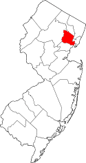 | |
| Boroughs | ||
| Townships | ||
| CDPs and planned communities | ||
 |
Montclair Township | Clifton | | |
| Glen Ridge | |
Nutley Township | ||
| ||||
| | ||||
| East Orange | Newark | Belleville Township |