Blekinge
| Blekinge | ||
|---|---|---|
| ||
 | ||
| Country | Sweden | |
| Land | Götaland | |
| County | Blekinge County | |
| Area | ||
| • Total | 3,055 km2 (1,180 sq mi) | |
| Population (Dec. 2012)[1] | ||
| • Total | 152,315 | |
| • Density | 50/km2 (130/sq mi) | |
| Ethnicity | ||
| • Language | Swedish | |
| Culture | ||
| • Flower | Oak and mullein | |
| • Animal | Lucanus cervus | |
| • Bird | Nuthatch | |
| • Fish | Cod | |
| Time zone | CET (UTC+1) | |
| • Summer (DST) | CEST (UTC+2) | |
| Area codes | 0454–0457 | |
Blekinge (Swedish pronunciation: [ˈbleːˈkɪŋə]) is one of the traditional provinces of Sweden (landskap), situated in the south of the country. It borders Småland, Scania and the Baltic Sea. It is the country's second-smallest province by area (only Öland is smaller), and the smallest province located on the mainland.
The name "Blekinge" comes from the adjective bleke, which corresponds to the nautical term for "dead calm".
Administration
The historical provinces of Sweden serve no administrative function. Blekinge is, however, the only province, besides Gotland, which covers exactly the same area as the administrative county, which is Blekinge County.
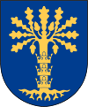
Blekinge was granted its current arms at the funeral of Charles X Gustav of Sweden in 1660, based on a seal from the 15th century. Symbolically the three crowns from the Coat of arms of Sweden had been placed on the trunk of the tree to mark the change in status of the former Danish province, that now belonged to Sweden. The arms is represented with a ducal coronet. Blazon: "Azure, an Oak Tree eradicated Or ensigned with three Crowns palewise of the same."
Geography
Blekinge has a scenic archipelago and is sometimes called the "Garden of Sweden".
History
Blekinge became part of the kingdom of Denmark at some point in the early 11th century – most likely 1026. Its status before then is unknown. It then remained a Danish province for over 600 years, and together with the provinces of Skåne and Halland, it made up the eastern part of the Danish kingdom where Scanian Law prevailed. As a border province Blekinge was often raided and looted by Swedish troops during Danish–Swedish wars. In 1658 it was ceded to Sweden according to the Treaty of Roskilde and has remained Swedish ever since.
During the Danish era, Sölvesborg was the seat of the administration in the western part of the province and Kristianopel in the eastern part. Whereas the Lister Hundred belonged to Skåne. Notable castles during this period were Elleholm, Sölvesborg, Lyckeby and Avaskär. Towns in Blekinge with city privileges were: Ronneby (1387), Sölvesborg (1445), Elleholm and Kristianopel. After the Swedish takeover two new towns, Karlshamn (chartered in 1664) and Karlskrona (1680), were built, and the populations of Ronneby and Kristianopel were forcibly relocated to them. Karlskrona has for more than 300 years been the principal naval base in Sweden.[2]
Subdivisions
Hundreds (in Götaland incl. Blekinge called härad in Swedish, in Svealand called hundare) were the historical subdivisions of a Swedish province. Blekinge's hundreds were Bräkne Hundred, Eastern Hundred, Lister Hundred, and Medelstad Hundred.
Language
In Blekinge two main dialects exist. The dividing line between them has historically been the Mörrumsån, near the historical site of Elleholm. West of this divide, the dialect was historically closely related to Danish and eastern Scanian, which is most likely an effect of the former administrative links to Scania. East of this divide, the dialect has more in common with Småland dialects. Today, this divide is not as significant as before, with the exception of Listerlandet with its special language. The eastern dialect of Danish can also be found on the Danish island of Bornholm.
The variety is called Blekingska but should rather be divided into Western Blekingska (or Västblekingska) and Eastern Blekingska (or Östblekingska).
Sports
Football in the province is administered by Blekinge Fotbollförbund.
See also
References
- ↑ Archived August 20, 2010, at the Wayback Machine.
- ↑ "Naval Port of Karlskrona - World Heritage Site - Pictures, info and travel reports". Worldheritagesite.org. Retrieved 18 February 2015.
External links
- Blekinge - Official tourist site
| Wikivoyage has a travel guide for Blekinge. |
Coordinates: 56°20′N 15°20′E / 56.333°N 15.333°E