Blake Plateau
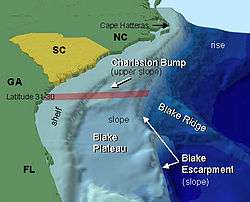

The Blake Plateau lies in the western Atlantic Ocean off the southeastern United States coasts of North Carolina, South Carolina, Georgia and Florida. The Blake Plateau lies between the North American continental shelf and the deep ocean basin extending about 145 kilometers (90 miles) east and west by 170 kilometers (106 miles) north and south, with a depth of about 500 meters (1,640 feet) inshore sloping to about 1,000 meters (3,281 feet) about 375 kilometers (233 miles) off shore, where the Blake Escarpment drops steeply to the deep basin.[1] The Blake Plateau, associated Blake Ridge and Blake Basin are named for the U.S. Coast and Geodetic Survey steamer George S. Blake, in service 1874-1905,[2] that first used steel cable for oceanographic operations and pioneered deep ocean and Gulf Stream exploration.[3] Survey lines of the steamer Blake first defined the plateau that now bears the ship's name.[4]
History
In July 1880 Blake under the command of Commander John R. Bartlett, [Note 1] U.S.N., was working with sounding gear designed by Lieutenant Commander Sigsbee in cooperation with Alexander Agassiz collecting biological samples and examining the Gulf Stream running eastward from Cape Romain when, in taking frequent soundings eastward, "depths on this line were unexpectedly small, the axis of the Gulf Stream being crossed before a depth of three hundred fathoms (1,800 feet/549 meters) was found" with a bottom of "hard coral" and little life.[5] This was early indication of the plateau that would in the future carry the ship's name. In 1882 Commander Bartlett described the plateau:
Instead of a deep channel in the course of the Stream as reported by Lieutenants Maffit and Craven, and published in the Coast Survey Reports, our later soundings show an extensive and nearly level plateau, extending from a point to the eastward of the Little Bahama Banks to Cape Hatteras—off Cape Canaveral nearly 200 miles wide, and gradually contracting in width to the northward until reaching Hatteras, where the depth is more than 1000 fathoms within thirty miles of shore. This plateau has a general depth of 400 fathoms, suddenly dropping off on its eastern edge to over 2000 fathoms.[6][7]
Bartlett reported the scouring effect of the current on the plateau, noting that on each side of the current the sounding cylinder, a device for sampling the nature of the bottom with the sounding, brought up ooze. Within the current the "bottom was washed nearly bare", with particles being small and broken pieces of coral rock and so hard the sharp edge of the brass cylinder was bent.[8]
Characteristics

Geology
Due to unusual features of the plateau, particularly scouring by the Florida Current and the Antilles Current that merge over the plateau to form the Gulf Stream,[9] mineral deposits, particularly manganese nodules, have long been of interest.[10][11] Methane and other gas hydrates are also found on the plateau.[12]
Biology
The Blake Plateau, although described as a "bleak, current-swept plain," has biological communities including Lophelia pertusa reefs that support communities[13] as well as communities supported by gas hydrates.[12] Commercial fishermen have begun exploiting deep sea fish on the plateau with studies being undertaken on the viability as these fish, although large, grow slowly.[14] Biological sampling of the deep, hard bottom is difficult under the Gulf Stream with the consequence that the fauna is relatively poorly known.[15][16]
See also
Notes
- ↑ The Navy oceanographic ship USNS Bartlett (T-AGOR-13) was named in his honor.
References
- ↑ Leslie R. Sautter. "A Profile of the Southeast U.S. Continental Margin". NOAA Ocean Explorer. National Oceanic and Atmospheric Administration (NOAA). Retrieved 7 February 2012.
- ↑ National Oceanic and Atmospheric Administration (NOAA). "George S. Blake". NOAA History-Coast and Geodetic Survey Ships. National Oceanic and Atmospheric Administration (NOAA). Retrieved 7 February 2012.
- ↑ National Oceanic and Atmospheric Administration (NOAA). "History of NOAA Ocean Exploration-Exploration Intensifis (1872-1888)". NOAA Ocean Explorer. National Oceanic and Atmospheric Administration (NOAA). Retrieved 7 February 2012.
- ↑ A. Lindenkohl (1882). "Southern half of rough draft of Chart of Atlantic Ocean by A. Lindenkohl. This survey was conducted by the Coast and Geodetic Survey Steamer BLAKE and shows the discovery of the Blake Plateau north of the Bahama Islands and south of Cape Hatteras.". Chart (Image ID: cgs05430, NOAA's Historic Coast & Geodetic Survey (C&GS) Collection ). Coast and Geodetic Survey. Retrieved 8 February 2012.
- ↑ U.S. Coast and Geodetic Survey (1883). Report of the Superintendent of the Coast and Geodetic Survey Showing the Progress of the Work During the Fiscal Year Ending with June, 1881 (pdf). Washington, D.C.: U.S. Government Printing Office. pp. 29–30.
- ↑ Bartlett,, Commander John R.,USN (1882). "The Gulf Stream". Proceedings of the United States Naval Institute. United States Naval Institute. VIII (20): 224.
- ↑ Pillsbury, John Elliot. "The Gulf Stream-Chapter III-Gulf Stream Investigations made by the U.S. Coast Survey Until 1884 and those Contemporary with Them". NOAA History. National Oceanic and Atmospheric Administration (NOAA). Retrieved 8 February 2012.
- ↑ U.S. Coast and Geodetic Survey (1883). Report of the Superintendent of the Coast and Geodetic Survey Showing the Progress of the Work During the Fiscal Year Ending with June, 1882 (pdf). Washington, D.C.: U.S. Government Printing Office. pp. 36–37.
- ↑ U.S. Geological Survey (2007). "U.S. Geological Survey GLORIA Mapping Program, USGS Coastal and Marine Geology Program, U.S. EEZ Atlantic Continental Margin GLORIA, GLORIA Geology Interpretation (See Blake Plateau)". U.S. Geological Survey. Retrieved 7 February 2012.
- ↑ Pratt RM, McFarlin PF. (1966). "Manganese pavements on the blake plateau. (Abstract)". Science. 1966 Mar 4. Retrieved 7 February 2012.
- ↑ John R Clarke. "Those Curious Manganese Nodules: from Intelligence History to Science Mystery". Retrieved 7 February 2012.
- 1 2 National Oceanic and Atmospheric Administration (NOAA). "Interview with Dr. Cindy Lee Van Dover". NOAA Ocean Explorer. National Oceanic and Atmospheric Administration (NOAA). Retrieved 7 February 2012.
- ↑ South Atlantic Fishery Management Council (2012). "Lophelia pertusa". Habitat Management - Deepwater Corals. South Atlantic Fishery Management Council. Retrieved 7 February 2012.
- ↑ Kelly Filer. "Expanding Fisheries and Fishery Potential on the Blake Plateau". NOAA Ocean Explorer. National Oceanic and Atmospheric Administration (NOAA). Retrieved 7 February 2012.
- ↑ George Sedberry. "Estuary to the Abyss: Exploring Along the Latitude 31-30 Transect September 1, 2004". NOAA Ocean Explorer. National Oceanic and Atmospheric Administration (NOAA). Retrieved 7 February 2012.
- ↑ "An Overview of Marine Biodiversity in United States Waters (See "Blake Plateau")". Public Library of Science. 2010. Retrieved 7 February 2012.
External links
- Blake Plateau features (NOAA)
- U.S. Geological Survey GLORIA Mapping Program, USGS Coastal and Marine Geology Program, U.S. EEZ Atlantic Continental Margin GLORIA, GLORIA Geology Interpretation (See Blake Plateau)
Coordinates: 31°N 79°W / 31°N 79°W