Black's Beach
Black's Beach is a secluded section of beach beneath the bluffs of Torrey Pines on the Pacific Ocean in La Jolla, San Diego, California, United States. It is officially part of Torrey Pines State Beach. The northern portion of Black's Beach is owned and managed by the California Department of Parks and Recreation, while the southern portion of the beach, officially known as Torrey Pines City Beach, is jointly owned by the city of San Diego and the state park, but is managed by the city of San Diego.[1][2] This distinction is important as Black’s Beach is most known as a nude beach, a practice that is no longer permitted in the southern portion managed by the city of San Diego.[3]
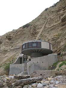
Black's Beach was named for the Black family who had a horse farm overlooking the beach. They sold the land, and then it was subdivided into La Jolla Farms lots. The Farms' residents retained the Black family’s private road to the beach.[4] Many mansions can be seen in the southern portion of the beach, including the Salk Mansion. There is a funicular that goes all the way down from a mansion on the cliff to the beach into a structure known by locals as the mushroom house.[5]
A submarine canyon funnels swells into Black's Beach, making it appealing to surfers but dangerous for inexperienced swimmers.[6] Usually, lifeguards are at the beach until 6:00 p.m., year round.[7] Due to budget cuts, lifeguard patrols were limited but have increased because of funding by UCSD.[8] Stingrays can be found along the coastline when the water gets above 50 degrees.
Location
Black's Beach is about three miles north of the popular La Jolla Shores beach in La Jolla, San Diego, California, below the bluffs of Torrey Pines, which extend up to 300 feet (91 m) above the sandy beach. On the bluffs above Black’s Beach are the Torrey Pines Gliderport, Torrey Pines Municipal Golf Course, Salk Institute for Biological Studies, and Torrey Pines State Reserve. To the north of Black’s Beach lies the rest of Torrey Pines State Beach, which altogether stretches 4.5 miles (7.2 km) from Del Mar, California, past the Los Peñasquitos Lagoon toward Scripps Beach
Nude beach
Black's Beach in San Diego is the one of the largest nude beaches in the United States[9] and is popular with Southern Californian nudists and naturists. Originally including the current Torrey Pines State Beach, Black's Beach was the first and only public nude beach in the country for several years in the mid-1970s.[3] Because Black's Beach was traditionally recognized as a clothing optional beach, nudity is tolerated for the portion of the beach that is managed by the state park.[1][10] Until 1977, the city portion of Black's Beach was posted as "swimsuit optional"; in that year, nudity was prohibited on that part of the beach.[11]
The clothing-optional portion of Black's Beach begins about 100 yards (91 m) south of the trail head leading to the Torrey Pines Gliderport, and runs north for approximately 1.1 miles (1.8 km) to the beached steel buoy south of Flatrock Point.[12]
Surfing
The southern portion of Black's Beach is known to surfers as one of the most powerful surf breaks in Southern California.[13] The waves gain their power due to the focusing effects of Scripps Canyon, an underwater canyon just offshore in the San Diego-La Jolla Underwater Park.[14][15] Because of the sometimes large surf, fast breaking waves, and aggressive crowds, Black's is a dangerous surfing location, advisable for advanced surfers only.[16]
Access
Black’s Beach can be difficult to access due to its location beneath the Torrey Pines bluffs. Landslides can occur, with tragic results. Beachgoers are warned to avoid setting up beach sites too close to the cliffs. [17] There are four access routes to Black’s Beach.[18][19]
Torrey Pines Gliderport Trail – the most popular route to Black’s Beach is via the trail from the Gliderport, located between the Torrey Pines Gliderport and the Salk Institute for Biological Studies. This steep rugged trail down the 300-foot (91 m) cliffs is usually well maintained by local nudists of the beach, but the city of San Diego posted a “Do Not Use” sign there, as the Torrey Pines cliffs are unstable. Visitors are advised to stay on the designated trails since many people have gotten stuck or even fallen to their deaths on the cliffs.[20][21][22]
Salk Canyon Road from UCSD – Students from the University of California, San Diego have access to this steep, 0.5-mile (0.80 km) long, gated, paved road at the southern end of Black’s Beach, which is popular with surfers. The clothing-optional portion of the beach begins 0.5-mile (0.80 km) north of this access point.
Torrey Pines State Beach – A 2-mile (3.2 km) walk south from the parking lot at the base of Torrey Pines State Reserve, along the steep cliffs, and past Flatrock arrives at Black’s Beach.
La Jolla Shores – If the tide is low, a 3-mile (4.8 km) walk north from La Jolla Shores beach, past Scripps Pier and the rocky tidepools of Scripps Beach takes visitors to Black’s Beach. The route is blocked at high tides. During low tide, it is also possible to walk from Torrey Pines State beach to Black's Beach.
- Black's Beach
-
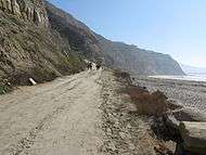
Black's Beach
-

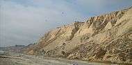
The cliffs at Black's Beach
-

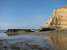
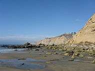
Black's Beach, view south toward La Jolla
-
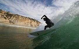
A surfer at Black's, with cliffs in background
- Black's Beach access
-

Black's Beach Trail from Gliderport
-
Black's Beach access from Salk Canyon Road, UCSD
-

Black's Beach access from the North (Torrey Pines Beach)
-
Black's Beach Access from South (Scripps Beach/La Jolla Shores)
See also
- Beaches in San Diego, California
- List of beaches in the United States
- Clothes free organizations
- List of public outdoor clothes free places
- Naturism
- Nude beach
- Public nudity
| To the North: Torrey Pines State Beach |
California beaches | To the South La Jolla Shores |
References
- 1 2 Goya, Alexander; Lynn Goya (2011). Best Hikes Near San Diego. Morris Book Publishing. p. 59. Retrieved June 18, 2014.
- ↑ "Blacks Beach". San Diego Fire-Rescue Department Lifeguard Services. Archived from the original on June 18, 2014. Retrieved June 18, 2014.
- 1 2 Black's Beach - La Jolla, California - Clothing-Optional Beach near San Diego
- ↑ La Jolla, A Celebration of Its Past. Patricia Daly-lipe and Barbara Dawson
- ↑ "Blacks Beach CA - Secluded Blacks Beach in La Jolla California". San-diego-beaches-and-adventures.com. 2011-06-26. Retrieved 2011-07-03.
- ↑ "2 Swimmers Rescued At Black's Beach - San Diego News Story - KGTV San Diego". 10news.com. 2010-05-07. Retrieved 2011-07-03.
- ↑ Black's Beach La Jolla | Directions, Hours, Amenities, Rules | SanDiego.com
- ↑ UCSD Agrees to Pay for Black's Beach Lifeguards | NBC 7 San Diego
- ↑ Blacks Beach
- ↑ California State Park Rangers Association. "The Cahill Memo and Its Effect on Enforcing CCR 4322 "Nudity" in California State Parks". Retrieved 2009-12-01.
- ↑ "NBC Evening News, Sept 21, 1977". Tvnews.vanderbilt.edu. 1977-09-21. Retrieved 2011-07-03.
- ↑ Black's Beach Bares. "Boundaries of Black's Beach". Retrieved 2009-12-01.
- ↑ Bremner, Jade (July 1, 2013). "World's 50 best surf spots". CNN. Archived from the original on June 18, 2014. Retrieved June 18, 2014.
- ↑ Bremner, Jade (July 1, 2013). "How is sound used to measure waves in the surf zone?". Discovery of Sound in the Sea. Archived from the original on June 18, 2014. Retrieved June 18, 2014.
- ↑ Blacks beach - Surfing in San Diego County, United States of America - WannaSurf, surf spots atlas, surfing photos, maps, GPS location
- ↑ Whitlock, Jared (January 24, 2011). "San Diego Surf Guide". San Diego Magazine. Archived from the original on June 18, 2014. Retrieved June 18, 2014.
- ↑ Man Dies at Toreey Pines State Beach Surfer Magazine
- ↑ Black's Beach Bares. "Access to Black's Beach". Retrieved 2007-09-15.
- ↑ abeach4u. "Directions to Black's Beach". Retrieved 2009-12-01.
- ↑ "Nude Woman Rescued on Cliffs at Blacks Beach". cbs8.com. Retrieved 30 June 2011.
- ↑ Biebesheimer, Kyle (12 February 2001). "UCSD Freshman Dies in Fall at Blacks Beach". UCSD Guardian. Retrieved 30 June 2011.
- ↑ "Woman's body found on cliff near Black's Beach". 14 February 2010. cbs8.com. Retrieved 30 June 2011.
External links
- California State Parks: Torrey Pines State Beach webpage
- City of San Diego - Black’s Beach page
- Cover story in the San Diego Reader about Black's Beach
- Naturist Society
| Wikimedia Commons has media related to Black's Beach. |
Coordinates: 32°53′21″N 117°15′11″W / 32.88916°N 117.25316°W