Blackhawk, South Dakota
| Black Hawk, South Dakota | |
|---|---|
| CDP | |
 Location in Meade County and the state of South Dakota | |
 Black Hawk, South Dakota Location in the United States | |
| Coordinates: 44°9′6″N 103°18′41″W / 44.15167°N 103.31139°WCoordinates: 44°9′6″N 103°18′41″W / 44.15167°N 103.31139°W | |
| Country | United States |
| State | South Dakota |
| County | Meade |
| Area | |
| • Total | 2.2 sq mi (5.6 km2) |
| • Land | 2.2 sq mi (5.6 km2) |
| • Water | 0 sq mi (0 km2) |
| Elevation | 3,494 ft (1,065 m) |
| Population (2010)[1] | |
| • Total | 2,892 |
| • Density | 1,314.5/sq mi (516.4/km2) |
| Time zone | Mountain (MST) (UTC-7) |
| • Summer (DST) | MDT (UTC-6) |
| ZIP code | 57718 |
| Area code(s) | 605 |
| FIPS code | 46-05780[2] |
| GNIS feature ID | 1265129[3] |
Black Hawk (sometimes Black hawk) is an unincorporated census-designated place (CDP) in Meade County, South Dakota, United States. The population was 2,892 at the 2010 census. Black Hawk has been assigned the ZIP code of 57718. Located along Interstate 90, Black Hawk is part of the Rapid City metropolitan area.
History
Black Hawk was platted in 1887.[4] It took its name from a nearby creek which was named for Black Hawk, a Sauk chief.[4]
Geography
Black Hawk is located at 44°9′6″N 103°18′41″W / 44.15167°N 103.31139°W (44.151575, -103.311420).[5]
According to the United States Census Bureau, the CDP has a total area of 2.2 square miles (5.7 km2), all land. Black Hawk is located north of Box Elder Creek, west of Interstate 90, south of the City of Summerset, and east of the Black Hills National Forest.
Demographics
| Historical population | |||
|---|---|---|---|
| Census | Pop. | %± | |
| 1980 | 1,608 | — | |
| 1990 | 1,995 | 24.1% | |
| 2000 | 2,432 | 21.9% | |
| 2010 | 2,892 | 18.9% | |
| U.S. Decennial Census | |||
As of the census[2] of 2000, there were 2,432 people, 847 households, and 665 families residing in the CDP. The population density was 1,119.8 people per square mile (432.7/km²). There were 871 housing units at an average density of 401.1 per square mile (155.0/km²). The racial makeup of the CDP was 94.86% White, 0.29% African American, 2.75% Native American, 0.21% Asian, 0.04% Pacific Islander, 0.04% from other races, and 1.81% from two or more races. Hispanic or Latino of any race were 1.60% of the population.
There were 847 households out of which 46.9% had children under the age of 18 living with them, 61.3% were married couples living together, 12.8% had a female householder with no husband present, and 21.4% were non-families. 15.3% of all households were made up of individuals and 3.3% had someone living alone who was 65 years of age or older. The average household size was 2.87 and the average family size was 3.17.
In the CDP the population was spread out with 32.4% under the age of 18, 8.0% from 18 to 24, 34.5% from 25 to 44, 19.8% from 45 to 64, and 5.3% who were 65 years of age or older. The median age was 32 years. For every 100 females there were 97.7 males. For every 100 females age 18 and over, there were 94.6 males.
The median income for a household in the CDP was $44,414, and the median income for a family was $47,154. Males had a median income of $34,135 versus $24,444 for females. The per capita income for the CDP was $17,364. About 10.1% of families and 12.2% of the population were below the poverty line, including 22.0% of those under age 18 and 4.5% of those age 65 or over.
Schools
Black Hawk is home to one elementary school, the current building was built in 1984 to house the expanding population. Black Hawk Elementary is included in the Rapid City School District.[6]
References
- ↑ "2010 Census Redistricting Data (Public Law 94-171) Summary File". American FactFinder. United States Census Bureau. Archived from the original on 21 July 2011. Retrieved 26 March 2012.
- 1 2 "American FactFinder". United States Census Bureau. Archived from the original on 2013-09-11. Retrieved 2008-01-31.
- ↑ "US Board on Geographic Names". United States Geological Survey. 2007-10-25. Retrieved 2008-01-31.
- 1 2 Chicago and North Western Railway Company (1908). A History of the Origin of the Place Names Connected with the Chicago & North Western and Chicago, St. Paul, Minneapolis & Omaha Railways. p. 44.
- ↑ "US Gazetteer files: 2010, 2000, and 1990". United States Census Bureau. 2011-02-12. Retrieved 2011-04-23.
- ↑ "Rapid City Area Schools: Black Hawk Elementary".
Municipalities and communities of Meade County, South Dakota, United States | ||
|---|---|---|
| Cities | 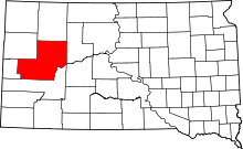 | |
| CDPs |
| |
| Other unincorporated communities | ||
| Indian reservations | ||
| Ghost towns | ||
| Footnotes | ‡This populated place also has portions in an adjacent county or counties | |