Black Rock, Bridgeport
| Black Rock | |
|---|---|
| Neighborhood of Bridgeport | |
|
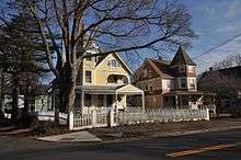
St. Mary's-by-the-sea, a popular park on the south side of the Black Rock neighborhood | |
 Location in Bridgeport | |
| Municipal | City of Bridgeport |
| NECTA | Bridgeport-Stamford |
| Region | Greater Bridgeport |
| County | Fairfield County |
| Settled | 1644 |
| Population (2006) | |
| • Total | 9,979 |
| Time zone | Eastern (UTC-5) |
| • Summer (DST) | Eastern (UTC-4) |
| ZIP code | 06605 |
| Area code(s) | 203 |
| FIPS code | 09-08000 |
| GNIS feature ID | 0205720 |
| Website | http://www.blackrockcc.org/ |

Black Rock is a neighborhood in the southwestern section of the city of Bridgeport, Connecticut. It was part of the Town of Fairfield before the State of Connecticut granted the land to Bridgeport. It borders Fairfield and the Ash Creek tidal estuary on the west, the West Side/West End of Bridgeport on the north and east, and Black Rock Harbor and Long Island Sound on the south.
Black Rock comprises census tracts 701 and 702 and part of census tract 703.[1] It includes two historic districts.
The Black Rock neighborhood has a mix of residential and commercial properties, with most of the retail stores being located along Fairfield Avenue, the main thoroughfare, which connects Black Rock to Fairfield and downtown Bridgeport. Fairfield Avenue is in a state of transition with older businesses being replaced by upscale restaurants, cafes, espresso bars, gourmet ice cream shops, and art galleries. The Black Rock Branch Library renovation and expansion were completed in 2009. The library has been expanded from its original 6,000 square feet (560 m2) to 11,000 square feet (1,000 m2). Additionally, the entire facility has been modernized, with the installation of 12 public access computers, free Wi-Fi throughout the building and the construction of two large program rooms and a smaller conference room. The library is also fully accessible to persons with disabilities.
While businesses in Black Rock are located primarily along Fairfield Avenue, most of the 2,628 properties in Black Rock are for residential use. Residences comprise 86% of properties in Black Rock, 10% is commercial, and only 4% are industrial or other property classes.[1]
The residential areas lie on either side of Fairfield Avenue with less density closer to the waterfront. The area of least density is a section called St. Mary's-by-the-Sea and consists of Resident AA zoned properties which require a minimum lot of 11,250 SF, although most lots are larger than the minimum. Grovers Hill is the highest elevation in Black Rock and some of the most expensive properties in Black Rock are located on this hill with views of Long Island Sound. There are also direct waterfront properties, including two condominium complexes on the Sound and two on the Ash Creek tidal estuary. St. Mary's-by-the-Sea also has a 9-acre (36,000 m2) public park along the Sound with half a mile of sidewalks and an area for bird watching.
History
Black Rock was settled about the same time as Fairfield, which was many years before Brigeport even existed. As Bridgeport grew to be the largest city in Connecticut, Black Rock was absorbed into its city limits.
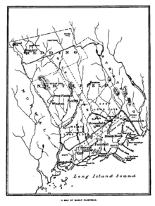
Before Black Rock was incorporated into Bridgeport, there was also the community of Stratfield which has also been absorbed into modern Bridgeport. Stratfield was originally known as Pequonnock and was located about midway between Black Rock and the original settlement of Bridgeport. The cemetery known as Stratfield Burying Place is located here and has many of Black Rock's early settlers interred there.
Historic districts
There are two historic districts in the neighborhood that have been listed on the National Register of Historic Places. One was listed in 1979 and includes houses and other structures. The district is known as Black Rock Historic District. The other is Black Rock Gardens Historic District. It has 12 buildings built for workers during World War I.
Lifestyle
Black Rock attracts artists, academics, young professionals, and retirees who desire to live in an affordable waterfront community on Long Island Sound. This Fairfield County community has been the focus of three articles by the New York Times over the past few years, "Living in St Mary's-by-the-Sea, Connecticut: The Saltwater Smell Means You're Home" (May 23, 2010), “Living in Black Rock, Connecticut: A Community with Spirit and an Edge” (August 8, 2004) and “If You’re Thinking of Living In St. Mary’s-by-the-Sea, Connecticut: At Peninsula’s End, a Waterside Enclave” (June 9, 2002).
Black Rock has become even more desirable since the Fairfield Metro train station construction was completed . Because technically the train station will be located in Fairfield, not Bridgeport, it is not to be called the Black Rock train station despite its proximity to the town line. The access road to the train station will connect to Brewster Street in Bridgeport. Black Rock is also convenient to I-95 for commuters to Stamford or New Haven.
Black Rock has a rich history dating back to its heritage as a colonial seaport. In the late 19th century and early 20th century wealthy merchants built beautiful homes in Black Rock. One of these homes with 3 acres (12,000 m2) of land and 16 rooms "("The Chimneys") is located on Old Battery Road. Old Battery Road is located on Grovers Hill, one of the highest elevations in Black Rock, which also affords views of the Sound. Grovers Avenue, Penfield Place, Beacon Street, and Anchorage Drive are also have direct waterfront properties and deep water docks.
The S. S. Norden Club (founded 1902), Captain’s Cove Seaport, Black Rock Yacht Club, Fayerweather Yacht Club, Harborview Market, & the Arts & Entertainment District on Fairfield Avenue offer culture, dining, and recreational activities. Black Rock is an artsy and eclectic community where newcomers are quickly integrated into the neighborhood as they join together on community projects and events.
Transportation
Fairfield Avenue is Black Rock's primary artery. Black Rock is also accessible from exits 24 and 25 on I-95 and from Route 1, both of which run just north of the area. Black Rock is served by a train station on Metro-North's New Haven Line, located just across Ash Creek in Fairfield called "Fairfield Metro Center" which opened in December 2011.
Community Council
The Black Rock Community Council (BRCC), founded in 1976, is the oldest and largest community membership organization in the area. The Council’s mission is to promote projects that will enhance the quality of life of Black Rock’s residents and businesses, including recreational, educational, and business development initiatives. Some of the Council’s activities include:
- The Black Rock Day Road Race, Parade & Picnic
- The Black Rock Newsletter
- Beautification Efforts
- Lighthouse Preservation
- Little League Sponsorship
- Christmas Tree Lighting
- Easter Egg Hunt
- Community Forums
- Public Safety/Block Watches
- Black Rock Business District Initiatives
- Scholarships
- Community Planning
Business Association
The Black Rock Business Association (BRBA), originated in 2005, is a group of Black Rock business owners who work together to promote Black Rock as a shopping, dining and entertainment district.
The Black Rock Business Association's activities include:
- Black Rock Harvest Hootenanny
- Managing local website and calendar for www.EnjoyBlackRock.com
- Seasonal neighborhood clean-up projects
- Business development workshops, open to the community
- Sponsorship of neighborhood enhancements, such as trash pick-up
Development
Fairfield Avenue in the Black Rock is going through significant revitalization which includes restaurants like Fire Engine Pizza Company and Walrus and Carpenter, art galleries, and a new library with WI-FI capabilities. The neighborhood's nearby waterfront, the location of the commercial corridor and the new commuter rail station have all had a positive effect on the area.[1][2]
Bodies of water
Weather
Black Rock has an overall moderate climate, the average January temperature is around 23 degrees (F) and the average high in July is 82 degrees (F).[3] Black rock has in the past been hit with a number of large winter snow storms. Although the average snowfall is 29", the following is the list of top snow-accumulating winters (October 1 - April 30):[4]
- 1995-96 - 75.7"
- 2002-03 - 64"
- 2010-11 - 62.6"
- 1966-67 - 61.6"
- 2012-13 - 61.3"
Notable residents
- John Ratzenberger, actor
- Christopher Shays, former Fourth District congressman
- David Walker, Comptroller General of the United States and head of the Government Accountability Office (GAO) and author of Comeback America (published January 2010)
- Sidney Wood, tennis player
Notes
- 1 2 3 "Neighborhood Revitalization Zone Plan, Black Rock Neighborhood, Bridgeport, CT, Final Draft" (PDF). March 8, 2008. Retrieved 2014-06-20.
- ↑ Black Rock NRZ Revitalization Plan
- ↑ US Climate data
- ↑ National Weather Service
External links
| Wikivoyage has a travel guide for Black Rock (Connecticut). |
- Black Rock Community Council
- "Living in St. Mary's-by-the-Sea, Connecticut" by C. J. Hughes in The New York Times Real Estate section, May 23, 2010
- Black Rock Community Blog
- Fayerweather Yacht Club
- Black Rock Yacht Club
- Black Rock Business Association
- "Black Rock's original historic district, dating back to the 17th century"
- "Black Rock's spy, Caleb Brewster, in the American Revolution"
- "Black Rock's earliest documented history, the Wheeler Diary
Further reading
- Black Rock: A Bicentennial Picture Book - A Visual History of the Old Seaport of Bridgeport: 1644 to 1976, edited and designed by Dick Jones and published by the Black Rock Civic and Men’s Club, Inc. in 1976.
Neighborhoods of Bridgeport | ||
|---|---|---|
|  | |
Municipalities and communities of Fairfield County, Connecticut, United States | ||
|---|---|---|
| Cities | 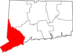 | |
| Towns | ||
| Borough | ||
| CDPs | ||
| Other communities | ||
Coordinates: 41°09′31″N 73°13′31″W / 41.15861°N 73.22528°W