Black Mountain (Kentucky)
| Black Mountain | |
|---|---|
.jpg) Black Mountain | |
| Highest point | |
| Elevation | 4,145 ft (1,263 m) [1] |
| Prominence | 1,905 ft (581 m) [2] |
| Listing | U.S. state high point 27th |
| Coordinates | 36°54′51″N 82°53′38″W / 36.91417°N 82.89389°WCoordinates: 36°54′51″N 82°53′38″W / 36.91417°N 82.89389°W |
| Geography | |
 Black Mountain | |
| Parent range | Cumberland Mountains |
| Topo map | USGS Benham |
| Climbing | |
| First ascent | unknown |
| Easiest route | Hike |
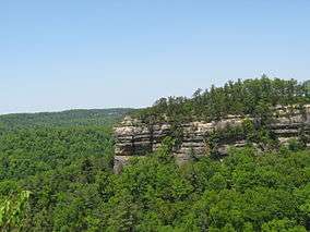
Black Mountain is the highest mountain peak in the Commonwealth of Kentucky, USA, with a summit elevation of 4,145 feet (1,263 m) [1] above mean sea level and a top to bottom height of over 2,500 feet (760 m). The summit is located at approximately 36°54′51″N 82°53′38″W / 36.91417°N 82.89389°W in Harlan County, Kentucky near the Virginia border, just above the towns of Lynch, Kentucky and Appalachia, Virginia. It is about 500 feet (150 m) taller than any other mountain in Kentucky.
Route 160 east of Lynch, Kentucky and west of Appalachia, Virginia crosses the mountain. The summit is reached by a narrow road that turns off to the right (coming from Lynch, KY or to the left, if coming from Appalachia, VA) at the Kentucky-Virginia line (the gap that is the highest part of Route 160) and leads past an FAA radar dome. There is a one lane dirt road to the left not far past the radar dome that leads to the summit. The summit is marked with an abandoned metal fire lookout tower (the cab and wooden steps are missing from the tower). There are also multiple radio towers along with transmitter buildings around the summit and a National Geodetic Survey benchmark is located on a large rock over the hill to the left of the fire tower. This benchmark is 6 feet below the highest point; [1] a second is directly under the old lookout tower, marking the latest survey of the highest natural point.
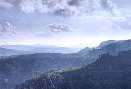
The FAA Radar dome is nearby, but below the summit. Trees on both sides of the radar dome have been cleared, so views of other mountains are visible. On a clear day the Great Smoky Mountains on the Tennessee and North Carolina border are clearly visible.
Black Mountain's history is intimately tied to the coal mining of the surrounding region. Lynch, Kentucky, was once one of the largest coal mining towns in the nation. In 1998, Jericol Mining, Inc., petitioned to use mountaintop removal methods in the area of Black Mountain. Though the summit itself was not directly threatened, many people protested this action due to the peak's status as the state's highest point. In 1999, Kentucky purchased mineral and timber rights to the summit and prevented future large scale mining. Coal companies have alleged that mined coal veins converge beneath the summit of Black Mountain and that the summit is prone to collapse.
A coal company named Penn Virginia Resources of Radnor, Pennsylvania owns the summit, but allows public access with the completion of a waiver.[3]
_summit.JPG)
Ecology
Black Mountain is one of the few sites in Kentucky supporting a Northern Hardwood Forest at higher elevations. Numerous rare plants and animals are found here, including Black Bear, Red Elderberry and Hobblebush. Like many areas of Northern Hardwood Forest in the Southern Appalachia, fires swept through the mountain after intense logging. Black Mountain has a documented fire that occurred in the fall of 1896.[4]
See also
References
- 1 2 3 "Science In Your Backyard: Kentucky" U.S. Department of the Interior | U.S. Geological Survey, July 3, 2006, retrieved August 25, 2006
- ↑ http://www.peaklist.org/USlists/KYTop50.html
- ↑ "New Address for Black Mountain, Kentucky Waiver". highpointers.org. February 5, 2010. Retrieved April 16, 2013.
- ↑ Clark, Thomas Dionysius (2004). The Greening of the South: The Recovery of Land and Forest (New Perspectives on the South), p. 47. University Press of Kentucky. ISBN 0-8131-9082-7.
External links
- Required waiver for summit access Note: The waiver has a drawing that shows the elevation of Black Mountain as 4,139 feet (1,262 m). As shown on the USGS website, this is incorrect. The correct elevation is 4,145 feet (1,263 m) at the summit. A USGS benchmark is located on a large rock over the hill at 4,139 feet (1,262 m), but it is not on the summit. The summit is apparently under the old fire lookout tower.
- Black Mountain Recreation Park