Black Lake (Nova Scotia)
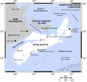
| Black Lake(s) | |
|---|---|
|
Map of Nova Scotia | |
| Location | Nova Scotia |
| Coordinates | various |
There are various Black Lakes in Nova Scotia, Canada.[1] They vary widely in size, depth and usability. Many counties, such as Cumberland, Halifax, Inverness, and Pictou Counties have more than one Black Lake so named, while other counties mentioned in this article have only one named Black Lake.
Colchester County

There a Black Lake in Colchester County, Nova Scotia south of the collector road 256 and north of the Highway 104 near Clear Lake. It is located at: 45°34′29″N 63°19′42″W / 45.5747222°N 63.3283333°W

Cumberland County
There are two Black Lakes in Cumberland County, Nova Scotia. One is located at 45°28′17″N 64°16′24″W / 45.47139°N 64.27333°W. This is the deepest lake in the province, with a depth of 72 metres (236 ft)[2] The lake is 5.7 miles (9.2 km) northeast of Parrsboro. Fish include brown trout, white perch and smallmouth bass.[3] The lake is surrounded by nutrient poor coniferous forest dominated by black spruce canopy, with high shrub and sphagnum moss cover.[4] As of 2005 there was a woodlot near the lake with about 200 specimens of the economically valuable Northern White Cedar.[5]
The other Black Lake in Cumberland county is located at 45°42′12″N 63°55′47″W / 45.703422°N 63.929793°W between Springhill and Oxford. As of 2010 about 200 eastern white cedars were present near the lake in a mixedwood and old field environment, with the oldest tree 148 years of age.[6]
Guysborough County
The Black Lake in Guysborough County, Nova Scotia is just west of the junction of collector road 316 with Old Country Harbour Road and Hendsbee Road. And north east of Eight Island Lake. It is located at: 45°21′39″N 61°56′54″W / 45.3608333°N 61.9483333°W
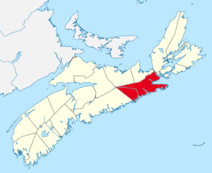
Halifax Regional Municipality
There are five Black Lakes in Halifax Regional Municipality. One is located at 44°42′37″N 63°35′34″W / 44.7103°N 63.5927°W in Dartmouth, Nova Scotia, east of the Bedford Basin, surrounded by urban area.[7] Another is located at 44°31′00″N 63°39′00″W / 44.51667°N 63.65000°W. In an attempt to improve the water quality of this black lake, 1,100 kilograms (2,400 lb) of basic slag was added to the lake in 1948, plus 300 kilograms (660 lb) of superphosphate.[8]

Inverness County
Black Lakes is a pair of lakes on Cape Breton Island in Inverness County, in north-western Nova Scotia, Canada that flow via MacIntyres Brook into Bras d'Or Lake.[9] It is located at: 45°47′29″N 61°07′16″W / 45.79139°N 61.12111°W
Lunenburg County
The Black Lake in Lunenburg County, Nova Scotia is west of the collector road 208 and Zwicker Falls by about 6 kilometers. The closest community is New Germany which is farther to the east. The lake is located at: 44°30′34″N 64°50′32″W / 44.50946°N 64.84227°W

Pictou County
There are four Black Lakes in Pictou County, Nova Scotia. One is located at 45°24′0″N 62°19′0″W / 45.40000°N 62.31667°W, just to the west of Eden Lake.[7][10] The lake is drained by the East River, Pictou, which flows into the Northumberland Strait. It is surrounded by forestry land. Chain pickerel, which is not a native species in Nova Scotia, was illegally introduced around 1998.[11] The lake used to have a good population of speckled trout, and several other species, but since the pickerel were introduced the trout, perch and minnows have no longer been found. An estimated 1,100 pickerel were in the lake in 1998, some as large as 1.25 kilograms (2.8 lb).[12] The lake is open for winter fishing of chain pickerel by holders of a general fishing license. In 2006 the season was 1 January to 31 March, with a bag limit of 25 fish per day.[13] The same dates and bag limit applied in 2011.[14] On 19–20 February 2011 the ministry threw the lake open to fishers who did not have a license.[15] In 2012 the lake was open all year for chain pickerel fishing.[16]

Queens County
Black Lake, Queens County, Nova Scotia is located at 44°12′10″N 64°58′59″W / 44.202835°N 64.983018°W, near the eastern bank of Lake Rossignol, northwest of Georges Lake.[7]

Victoria County
Black Lake, Victoria County, Nova Scotia is located at 46°52′35″N 60°33′35″W / 46.8763888°N 60.5597222°W, off the Cabot Trail, northeast of Morrisons Lake.[7] This lake has an elevation of 114 metres (374 ft).[17]

Yarmouth County
The Black Lake in Yarmouth County, Nova Scotia is about 27 kilometers south west of Lake Rossignol and it is the third lake just west of the collector road 203. About equidistance to the south along 203 is the town of Shelburne within Shelburne County. The lake is located at: 44°01′54″N 65°29′52″W / 44.0316666°N 65.4977777°W
Complete list
Coordinates of all the Black Lakes are:[18]
See also
References
- ↑ Nova Scotia Geomatics Centre (2006-06-30). The Nova Scotia Atlas. Formac Publishing Company. p. 94. ISBN 978-0-88780-707-7. Retrieved 2012-08-20.
- ↑ "Glenville, Nova Scotia". Rick Adshade. Retrieved 2012-08-20.
- ↑ "Black Lake Fishing near Parrsboro, Nova Scotia". Hook and Bullet. Retrieved 2012-08-20.
- ↑ "WC2 black spruce / Lambkill – Labrador tea / Sphagnum" (PDF). Forest Ecosystem Classification for Nova Scotia Part I: VegetatIon types. Government of Nova Scotia. 2010. Retrieved 2012-08-20.
- ↑ Ruth E. Newell (March 2005). "Provincial (Nova Scotia) Status Report on Northern White Cedar" (PDF). Nova Scotia Department of Natural Resources. Retrieved 2012-08-20.
- ↑ Michée Joseph Lemieux (July 2010). "A MANAGEMENT PLAN FOR NATIVE OCCURRENCES OF EASTERN WHITE CEDAR (Thuja occidentalis L.) IN NOVA SCOTIA" (PDF). Nova Scotia Department of Natural Resources. Retrieved 2012-08-20.
- 1 2 3 4 Maps (Map). Google Maps.
- ↑ Eville Gorham (1956). "The Chemical Composition of Lake Waters in Halifax County, Nova Scotia'" (PDF). Freshwater Biological Association, Ambleside, England. Retrieved 2012-08-20.
- ↑ "Toporama - Topographic Map Sheet 11F14". Atlas of Canada. Natural Resources Canada. Archived from the original on 2010-08-31. Retrieved 2010-02-06.
- ↑ "BLACK LAKE - PICTOU COUNTY" (PDF). Lake Inventory Maps. Government of Nova Scotia. Retrieved 2012-08-20.
- ↑ S.C. Mitchell; J.E. LeBlanc; A.J. Heggelin. "Impact of Introduced Chain Pickerel (Esox niger) on Lake Fish Communities in Nova Scotia, Canada" (PDF). Government of Nova Scotia. Retrieved 2012-08-20.
- ↑ "Chain Pickeral Continue to Spread" (PDF). Riffles & Pools. 3 (3): 2. Summer–Autumn 2002. Retrieved 2012-08-20.
- ↑ "Winter Sportfishing Season Opens Jan. 1". Nova Scotia. December 30, 2005. Retrieved 2012-08-20.
- ↑ "Winter Sportfishing Starts New Year's Day". Nova Scotia Fisheries and Aquaculture. December 30, 2010. Retrieved 2012-08-20.
- ↑ "Free Sportfishing Weekend Feb. 19-20". Nova Scotia Fisheries and Aquaculture. February 11, 2011. Retrieved 2012-08-20.
- ↑ "Nova Scotia Anglers' Handbook" (PDF). Nova Scotia Ministry of Fisheries and Aquaculture. 2012. Retrieved 2012-08-20.
- ↑ "Maps showing Black Lake, Victoria, Nova Scotia". Yellow Maps. Retrieved 2012-08-20.
- ↑ "Querying Canadian Geographical Names". Natural Resources Canada. Retrieved 2012-08-20.
| Provinces |
|
|---|---|
| Territories | |
| |