Black Forest, Colorado
| Black Forest, Colorado | |
|---|---|
| CDP | |
|
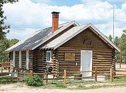
The Black Forest School. | |
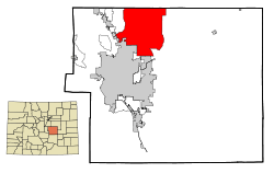 Location in El Paso County and the State of Colorado | |
| Coordinates: 39°2′12″N 104°40′40″W / 39.03667°N 104.67778°WCoordinates: 39°2′12″N 104°40′40″W / 39.03667°N 104.67778°W | |
| Country |
|
| State |
|
| County | El Paso County |
| Government | |
| • Type | unincorporated community |
| Area | |
| • Total | 127.6 sq mi (330.3 km2) |
| • Land | 127.5 sq mi (330.1 km2) |
| • Water | 0.1 sq mi (0.2 km2) |
| Elevation | 7,369 ft (2,246 m) |
| Population (2010) | |
| • Total | 13,116 |
| • Density | 103.8/sq mi (40.1/km2) |
| Time zone | MST (UTC-7) |
| • Summer (DST) | MDT (UTC-6) |
| ZIP codes | 80921 80908 |
| Area code(s) | 719 |
| FIPS code | 08-06970 |
| GNIS feature ID | 0193282 |
Black Forest is a census-designated place (CDP) in El Paso County, Colorado, near Colorado Springs.[1] The population was 13,116 at the 2010 census.[2] Black Forest is named such for the high density of Ponderosa Pines located in a generally small area. In 2006, residents voted against a proposal to incorporate as a city.
History
The history of the Black Forest area is closely paralleled by that of a larger area traditionally known as the "Pineries". The area originally extended from Divide, Colorado (now known as the town of Monument, Colorado), through the present planning area and east along the Platte-Arkansas Divide to a point where the Ponderosa Pines thinned out. Altogether the Pineries encompassed a 1,000 square mile area. Although the origin of the name is not clear, that portion of the Pineries north of Colorado Springs became known as the "Black Forest" by around the turn of the century.[3]
Arrowheads and charcoal pits provide evidence that the planning area was occupied by Native Americans at least 800 years ago. The first known inhabitants were the Ute and Comanche Indians. The dense Ponderosa Pines provided them with protection, fuel, and timber for lodgepoles. These tribes were displaced by the Kiowas around 1800. Almost 40 years later, the Arapahoe and Cheyenne tribes joined forces to drive out the Kiowas and become the last Native Americans to inhabit the area.
When white people began to settle the region in the late 1850s the Black Forest became an important center of activity, primarily as a source of scarce timber. The first of what would be several dozen sawmills was constructed in 1860. General Palmer was the first major landowner of Black Forest when he established the Colorado Pinery Trust in 1870; he purchased 43,000 acres. Lumber and mine props were supplied to build Colorado Springs and Denver. An 1880 article from the Colorado Springs Gazette stated that for years nearly every foot of timber used in Denver was hauled from the Pineries. Logging in the Pineries reached its height in the summer of 1870 when over 700 teamsters and 1,000 lumberjacks and tie hacks were employed, mostly for railway work. More than one billion board feet of lumber were removed to provide ties for the Kansas Pacific, Denver and Rio Grande and New Orleans Railroads.
Although lumbering continued sporadically through the 1950s, farming and ranching had become the dominant activities by the 1880s. A wide variety of crops were raised including, cattle, sheep, alfalfa, wheat, corn, hay and beans. Potatoes, however, were the agricultural product for which the Black Forest area became most renowned. Agricultural productivity was subject to boom and bust cycles with crops often ruined by drought, floods, hail, blizzards, or grasshoppers. The drought of the 1920s and the Depression of the 1930s combined to eliminate most types of agriculture in the planning area. By the 1920s the area was mostly consolidated into large ranches. Some of these remain today.
Several towns and settlements dotted the planning area at one time or another during its history. The largest and most long-lived of these was the Town of Eastonville. Eastonville (actually located just to the east of the planning area) was begun in the early 1880s as a stop on the C & S Railroad. Its population peaked at about 400 in 1910 and was already in decline when the railroad ceased operations in 1935. Today only a few remnants of the once thriving townsite remain.
In the forest itself, modern subdivision had a fitful start in the 1920s when Dreamland and Brentwood Country Clubs were organized. Although these ventures were not particularly successful, they did represent the beginning of what would become a significant summer home market in the planning area. A boom in year-round subdivisions took place in the late 1950s and early 1960s. Most of the planning area was zoned for five acre minimum lot sizes in 1965.
Primarily in response to plans for a major transportation corridor through the eastern portion of the planning area, residents and County staff initiated work on a comprehensive land use plan in the early 1970s. The result of this effort was adoption of the Black Forest Preservation Plan in 1974. While this plan recommended rural-residential uses for most of the planning area, it also delineated several large areas for mixed urban uses. The largest of these was in the southeast where the new "city" of Latigo would later be proposed.
While Latigo has not materialized as envisioned, the Colorado Springs metropolitan area itself has expanded rapidly in the direction of the planning area. During the same period, numerous large lot residential subdivisions have been platted and developed in the planning area, allowing it to retain much of its rural character and a good bit of its historic legacy. Although some newer suburban subdivisions have been created within the boundaries of Black Forest such as Flying Horse Ranch, Black Forest still retains a rural image and legacy. Some of this legacy is in the form of remaining historic sites and structures.
While Black Forest is not an incorporated town, it is well known by that name. At first, the name was more informal but became "more official" with the opening of the Black Forest School (now named Edith Wolford Elementary) in 1923.[4][5]
2013 Black Forest Fire
On June 11, 2013, a forest fire started around Highway 83 and Shoup Road, within Black Forest. Nearly 35,500 people within and around Black Forest, Colorado Springs, and Elbert County were evacuated, and a portion of Douglas County was placed on pre-evacuation notice. 15,500 acres burned, 511 buildings were destroyed, and there were two fatalities.[6] Based on number of homes destroyed, it surpassed the Waldo Canyon Fire as the most destructive wildfire in Colorado history. It was concurrent with the Royal Gorge Fire in Fremont County, which threatened the Royal Gorge Bridge. Firefighters achieved 100% containment on approximately June 20, 2013.
Geography
Black Forest is located at 39°2′12″N 104°40′40″W / 39.03667°N 104.67778°W (39.036632, -104.677697).[7] According to the United States Census Bureau, the CDP has a total area of 127.5 square miles (330 km2), of which, 127.5 square miles (330 km2) of it is land and 0.1 square miles (0.26 km2) of it (0.05%) is water.
Demographics
As of the census[8] of 2000, there were 13,247 people, 4,494 households, and 3,851 families residing in the CDP. The population density was 103.9 people per square mile (40.1/km²). There were 4,639 housing units at an average density of 36.4 per square mile (14.1/km²). The racial makeup of the CDP was 95.08% White, 0.85% African American, 0.66% Native American, 0.71% Asian, 0.04% Pacific Islander, 0.88% from other races, and 1.77% from two or more races. Hispanic or Latino of any race were 3.31% of the population.
There were 4,494 households out of which 41.1% had children under the age of 18 living with them, 78.9% were married couples living together, 4.5% had a female householder with no husband present, and 14.3% were non-families. 10.7% of all households were made up of individuals and 2.2% had someone living alone who was 65 years of age or older. The average household size was 2.94 and the average family size was 3.17.
In the CDP the population was spread out with 29.5% under the age of 18, 5.1% from 18 to 24, 29.0% from 25 to 44, 30.2% from 45 to 64, and 6.2% who were 65 years of age or older. The median age was 40 years. For every 100 females there were 102.6 males. For every 100 females age 18 and over, there were 99.5 males.
The median income for a household in the CDP was $77,085, and the median income for a family was $80,556. Males had a median income of $59,568 versus $32,043 for females. The per capita income for the CDP was $30,786. About 1.9% of families and 2.9% of the population were below the poverty line, including 3.9% of those under age 18 and 2.3% of those age 65 or over.
See also
References
- ↑
- ↑ Colorado Trend Report 2: State and Complete Places (Sub-state 2010 Census Data). Missouri Census Data Center. Accessed 2011-02-25.
- ↑ "Black Forst History". Black Forest Preservation Plan. Retrieved 26 October 2011.
- ↑ "Black Forest History Tour DVD". Black Forest History Tour DVD. YouTube. Retrieved 26 October 2011.
- ↑ "History of EWE". EWE. Retrieved Edith Wolford Elementary School. Check date values in:
|access-date=(help) - ↑ "Black Forest Fire Has Consumed Nearly 8,000 Acres; Zero Containment". KKTV. 2013-06-11.
- ↑ "US Gazetteer files: 2010, 2000, and 1990". United States Census Bureau. 2011-02-12. Retrieved 2011-04-23.
- ↑ "American FactFinder". United States Census Bureau. Archived from the original on 2013-09-11. Retrieved 2008-01-31.
External links
| Wikimedia Commons has media related to Black Forest, Colorado. |
Municipalities and communities of El Paso County, Colorado, United States | ||
|---|---|---|
| Cities | 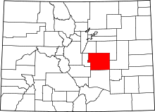 | |
| Towns | ||
| CDPs | ||
| Unincorporated communities | ||
| Footnotes | ‡This populated place also has portions in an adjacent county or counties | |