Bishops Cap
| Bishops Cap | |
|---|---|
|
Bishops Cap along the Garden Wall | |
| Elevation | 9,127 ft (2,782 m)[1] |
| Location | Flathead County, Montana, Glacier County, Montana, US |
| Range | Lewis Range |
| Coordinates | 48°43′29″N 113°42′33″W / 48.72472°N 113.70917°WCoordinates: 48°43′29″N 113°42′33″W / 48.72472°N 113.70917°W[2] |
| Topo map | USGS Logan Pass, MT |
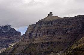
Bishops Cap (9,127 feet (2,782 m)) is located in the Lewis Range, Glacier National Park in the U.S. state of Montana.[1][3] Located above the Garden Wall and straddling the Continental Divide, when viewed from the south at Logan Pass, the peak appears to resemble a Bishop's headwear.[3] The name Bishops Cap is descriptive only, and there's no known origin.[4]
See also
References
- 1 2 "Bishops Cap, Montana" (map). Acme Mapper. Retrieved 2011-05-09.
- ↑ "Bishops Cap". Geographic Names Information System. United States Geological Survey. Retrieved 2010-09-26.
- 1 2 "Bishops Cap". SummitPost.org. Retrieved 2011-05-07.
- ↑ Holterman, Jack (2006). Place Names of Glacier National Park. Helena, MT: Riverbend Publishing. p. 34. ISBN 1-931832-68-4.
This article is issued from Wikipedia - version of the 12/23/2015. The text is available under the Creative Commons Attribution/Share Alike but additional terms may apply for the media files.