Bijlmermeer
| Bijlmermeer | |
|---|---|
| Neighbourhood | |
|
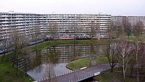
View from Gooioord in Bijlmer | |
| Nickname(s): Bijlmer | |
| Country | Netherlands |
| Province | North Holland |
| Municipality | Amsterdam |
| Borough | Amsterdam Zuidoost |
| Time zone | CET (UTC+1) |
| Area code(s) | 020 |
| Metro lines | 50, 53, 54 |

The Bijlmermeer ([ˈbɛi̯lmərˌmeːr]) or colloquially Bijlmer [ˈbɛilmər] is one of the neighbourhoods that form Amsterdam Zuidoost ('Amsterdam South-East') borough (or "stadsdeel") of Amsterdam, Netherlands. To many people, the Bijlmer designation is used to refer to Amsterdam Zuidoost and Diemen Zuid as a pars pro toto. The other neighbourhoods in Amsterdam Zuidoost are Gaasperdam, Bullewijk, Venserpolder and Driemond.
The Bijlmermeer neighbourhood, which today houses almost 100,000 people of over 150 nationalities, was designed as a single project. The original neighbourhood was designed as a series of nearly identical high-rise buildings laid out in a hexagonal grid. The apartments were meant to attract a suburban set, rather like condominium housing. The buildings have several features that distinguish them from traditional Dutch high-rise flats, such as tubular walkways connecting the flats and garages. The blocks are separated by large green areas planted with grass and trees. Each flat has its own garages where cars can be parked.
The Bijlmer was designed with two levels of traffic. Cars drive on the top level, the decks of which fly over the lower level's pedestrian avenues and bicycle paths. This separation of fast and slow moving traffic is conducive to traffic safety. However, in recent years, the roads are once again being flattened, so pedestrians, cycles and cars travel alongside each other. This is a move to lessen the effects of the 'inhuman' scale of some of the Bijlmer's designs. It is felt a direct line of sight will also improve safety from muggers.
Because of the Bijlmer's peripheral position relative to the city centre, it was decided that metro lines would be built connecting the Bijlmer with other neighbourhoods. The Oostlijn (east line, comprising two lines, numbered 53 and 54) links the Bijlmer to the Central Station of Amsterdam, while the Ringlijn links it with the port area at Sloterdijk.
Bijlmermeer in trouble

Until recently, Bijlmermeer struggled to draw in many middle-class families. Following Suriname's independence in 1975, many of its inhabitants migrated to the Netherlands. The government placed a substantial number of these immigrants in affordable social housing in the Bijlmermeer.
The neighbourhood once had a relatively high crime rate, but this has decreased dramatically in recent years. The number of registered complaints to the police decreased from 20,000 in 1995 (of which 2,000 were robberies) to 8,000 (of which 600 were robberies) in 2005.
The Bijlmer has always been home to many different ethnicities simultaneously. Throughout the years, claims of rising social segregation or ghettoization have been both denied, and pre-empted by local government.
Urban renewal
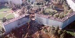
After El Al Flight 1862 crashed into two Bijlmermeer buildings in 1992, an incident known as the Bijlmerramp (Dutch for "Bijlmer Disaster"), it was decided that the neighbourhood needed some further change. In recent years, many of the high rise buildings have been renovated or torn down. More expensive low-rise housing has been being built to attract more middle- and upper-income residents. This resulted in significant reduction in crime and a more balanced socio-economic composition, whilst at the same time maintaining the area's ethnic mix. Lately students have discovered the Bijlmer as an affordable place to live compared to the city centre where space is limited and costs of living are high.[1]
Events and sights
Amsterdam Zuidoost is host to Ajax Amsterdam's ArenA football stadium, which hosts football matches and musical concerts, the Pathé ArenA multiplex cinema with 14 screens, the Heineken Music Hall and music and theatres, located in the business park area of Amsterdam Zuidoost, just to the west of the Bijlmer. The recreational strip is called the ArenA Boulevard. The strip mostly hosts concerts, with a very small number of bars and no night clubs. It has not been able to compete with Amsterdam's city centre for the casual Saturday night crowd.

The Bijlmer boasts Amsterdam's biggest shopping centre, the "Amsterdamse Poort", though Amsterdam's city centre remains the largest shopping area. Alongside the shopping centre, the "Anton de Kom plein" (square) is completed, it houses a cultural centre and the borough administrative offices ("stadsdeelkantoor").
In 2012 the entire area from the Ziggo Dome in the west, Villa Arena home furnishings mall, the ArenA Boulevard and stadium, and the Amsterdamse Poort started being marketed as "ArenaPoort".[2]
The 74,000 square metres (800,000 sq ft) mixed-use GETZ Entertainment Centre is planned to open on the ArenA Boulevard, including retail, catering industry, leisure, several types of entertainment, a hotel and a culture cluster.[3][4]
The annual Kwakoe Festival is a six-weekend long, free, multicultural festival during the summer, with Surinamese, Antillean and African food, music and other events.
Notable residents
- Ryan Babel, footballer
- Kevin Bobson, footballer
- Mitchell Donald, footballer
- Steve van Dorpel, footballer
- Akwasi Frimpong, sprinter
- Cerezo Fung-a-Wing, footballer
- Ortwin Linger, footballer
- Javier Martina, footballer
- Tyrone Spong, kickboxer
- Gilbert Yvel, mixed martial artist
Canon of Amsterdam
- Bijlmermeer is window nummer 46 in the Canon of Amsterdam.
See also
Coordinates: 52°19′N 4°58′E / 52.317°N 4.967°E
External links
Footnotes and references
- ↑ regio, dichtbij.nl – nieuws en informatie uit de (2013-10-30). "Zuidoost voor studenten zo gek nog niet". Retrieved 2016-08-28.
- ↑ ArenaPoort website, October 2012
- ↑ GETZ, Archello website
- ↑ Holland Real Estate Yearbook: assets, Industry Trends, Market Players, M. Dijkman
Neighborhoods of Amsterdam | ||
|---|---|---|
| Centrum (Centre) | ||
| Nieuw-West (New West) | ||
| Noord (North) | ||
| Oost (East) |
| |
| West | ||
| Zuid (South) | ||
| Zuidoost (Southeast) |
| |
| Westpoort |
| |
Add'l. former boroughs: De Baarsjes - Geuzenveld-Slotermeer - Oost-Watergraafsmeer - Oud-West - Oud-Zuid - Slotervaart - Westerpark - Zeeburg - Zuideramstel | ||