Bihsud District
| Bihsud District بهسود | |
|---|---|
| District | |
|
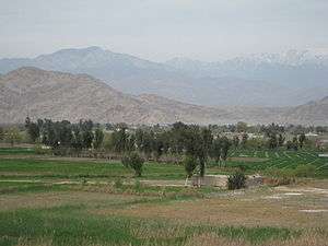
Rural Bihsud District, looking north from the outskirts of Jalalabad | |
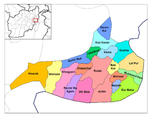 Bishsud District is located in the north-west of Nangarhar Province. | |
| Country |
|
| Province | Nangarhar Province |
| Time zone | D† (Afghanistan Standard Time) (UTC+4:30) |
Bihsud District (Pashto: بهسود, formerly Jalalabad District) (Persian: ولسوالی بهسود) is a district of Nangarhar Province, Afghanistan. The district, which contains 40 main villages, is located around the city Jalalabad, spanning both sides of the Kabul River. The district was previously a unit which contained the city of Jalalabad, but in 2004 the city became independently administered under the municipality system, and the portions of the district not contained within the city became Bihsud District. Oranges, rice, and sugarcane grow in the fertile district, and the capital city has cane-processing and sugar-refining as well as papermaking industries. The district's year-round summery weather attracts many visitors
As of 2002, the population was 120,000, composed of 55% Pashtun, 40% Afghan Arab, 5% Tajik. The primary employment is agriculture and animal husbandry.
History
Greco-Buddhist era
In the past Jalalabad was the major city of the ancient Greco-Buddhist center of Gandhara. The Buddhist pilgrim Faxian visited the district around the year 400AD, and his travelogue described the many Buddhist sanctuaries in the area. The archaeological site of the city of Hadda is located in the district, and was a Buddhist center from the time of Kanishka, with statues of the Buddha as high as sixty-six feet.[1]
Prior to the Islamic conquest, the Buddhist Kingdom of Kapisi stretched from Bamiyan to Jalalabad District.[2]
Communications
In September 2003, Internews established a Radio Sharq independent station in Jalalabad District.[3]
August 1, 2007 marked the grand opening of the new District Communications Center (DCC). The construction of the DCC had started more than nine months before by Combined Forces Command-Afghanistan, but was handed over to the Nangarhar Provincial Reconstruction Team (PRT) to oversee completion. The new building was eventually signed over from the Nangarhar PRT to Amirzi Sengi, Minister of Communications.[4]
Governance
In an Afghanistan Research and Evaluation Unit survey conducted on 11 February 2008, respondents in Behsud district noted that problems in the community had previously been solved by gatherings of elders in a jirga which would meet when necessary. The relationship between this pattern of dispute resolution and the Community Development Council (CDC) role was not entirely clear, but seemed to involve consultation between both types of institution in the case of small problems, such as youth opium addiction, and perhaps less in more important cases. On the other hand, this community mentioned the role of maliks and uluswal as well, noting these institutions had played roles in dispute resolution, but usually in a negative way through their favouritism or likelihood to be corrupt. Moreover, the unpopularity of the malik and the uluswal could have resulted in a heightened awareness of responsibility for community issues.[5]
Demographics
as of 2002, the ethnic makeup of the district was approximately 35% Pashtun Arabs of Afghanistan 45% and 20% Tajik. There were also 135 Hindu and Sikh families. The Khogiani tribe is centered in the area around Jalalabad.[6]
Records from 1885 indicate the presence of Afghan Arabs (almost entirely Pashto speaking, who were described as pastoralists and agriculturalists.[7]
Health
Jalalabad district has three hospitals: Fatumatu Zahra, Medical Hospital of Nangarhar, and the General Hospital of Public Health. The General Hospital of Public Health is one of the largest in the country.[8]
As of July 24, 2004, polio (NSL3) has been identified and reported in the Jalalabad district area. This specific case has been linked to others reported in the past due to the highly transient and mobile population.[9]
Infrastructure
As of early 2009, Alternative Development Program - Eastern Region (ADP/E) and USAID’s LGCD project have begun collaborating to build a park near the Behsud Bridge in Nangarhar, called Abdul Haq Park. ADP/E is conducting a topographical survey, and LGCD will provide funds to build the park. Together, they are working with local authorities and communities to plan the space according to the needs of the community.[10]
Commerce
- Al-Madina Sweets and Bakery: Seven years ago, a man named Qasim Kahn started a small, family-run bakery in Behsud District of Nangarhar Province. Today, the business accounts for almost 10% of the confection market in eastern Afghanistan, with customers flocking to its two locations for high-quality, tasty sweets. In early 2007, the bakery began receiving technical assistance from USAID’s Alternative Development Program—Eastern Region (ADP/E). The business has seen a 25% increase in total sales; current revenues exceed $30,000 per month.[11]
- The Nangarhar Handicraft Producers Association is located at Samarkhil Village of Behsud District. Formal vocational training was conducted in the reporting period. The project is jointly supported by ADP/E and the World Food Program (WFP). Equipment and necessary raw materials are provided by ADP/E and food supply is facilitated by WFP. The training is aimed to target 120 trainees by eight trainers in eight classes of embroidery. Main activities to be covered in the first month are napkins which are further composed of different kinds of embroideries like Zanjiradozi, Pukhtadozi, Khandaridozi, and Khanjaradozi.[12]
- In December 2007, the Commercial Poultry Development Program ADP/E distributed 10,000 day-old chicks with the collaboration of the Spin Ghar Poultry Farm Association to ten female operated poultry farms in the Behsud district. These ten farms represent the initial selection of the targeted 200 farms for the ADP/E project. The women have undergone commercial poultry management training by ADP/E’s women paravets. The poultry program supplies each farm with 400 day-old chicks, farm inputs and tools, and comprehensive training in poultry farm management. In order to maximize the flock, each farm also receives a $1000 loan to purchase 500 chicks and sufficient quantity of feed.[13]
Energy
Nangarhar has abundant water sources, and electricity in the Jalalabad area is provided by the Darunta Dam, built by the Soviet Union in 1957.[14]
Per 2009 UNDP reporting, the Energy for Rural Development in Afghanistan (ERDA) Project is installing 10 biogas plants in the district.[15]
Agriculture
An MAIL study on milk production and processing in June 2007 found Jalalabad district to be a recommended area for dairy development. The report stated a new dairy plant could be established near the city and collected in surrounding areas, serving the local market and selling dairy products in either Kabul or Pakistan.[16]
Opium
In 2003, UNODC declared Jalalabad District "virtually poppy-free", with a reduction from 90 hectares in 2002 to 4 in 2003.[17]
Human rights
In the period 2003-2005, Human Rights Watch expressed concerns over gender-based violence in the area of Jalalabad, particularly in terms of threats to young women which prevented them from attending school. Due to the threat of abduction, sometimes by men associated with and protected by local powerbrokers, many young women had ceased to attend school in Jalalabad and the surrounding towns, suburbs and villages.[18]
Natural Disasters
2006 flood
Flash floods caused by torrential rains struck Behsud district in the Nangarhar province (Jalalabad region) of eastern Afghanistan on 10 November 2006. An estimated 156 families were affected in Qasim Abad village (Behsud district), located 20 kilometres north of Jalalabad city. Five people were killed and nine injured in the village, while 50 houses were partially or totally destroyed.[19]
Arts and culture
Jalalabad District is home to various works of ancient Hindu art, though the 1908 Imperial Gazetteer of India notes that many depictions had been vandalized.[20] Inscriptions in Aramaic have also been found in the district, indicating the presence of Jewish tribes in the area.[21]
References
- ↑ Pratapaditya Pal, Los Angeles County Museum of Art. Indian sculpture: a catalogue of the Los Angeles County Museum of Art collection, Volume 0. University of California Press, 1986
- ↑ Ramesh Chandra Majumdar. The Arab invasion of India. Sheikh Mubarak Ali, 1974
- ↑ Sanjar Qiam. Independent Radio in Afghanistan. Internews Initiatives, Afghanistan. August 2004.
- ↑ Spc. Henry Selzer. Afghans take ownership of Jalalabad District Communications Center 173rd ABCT Public Affairs. September 1, 2007.
- ↑ AFGHANISTAN INSTITUTIONAL CASE STUDY: COMMUNITY DEVELOPMENT COUNCILS Afghanistan Research and Evaluation Unit, 11 February 2008.
- ↑ Frank Clements. Conflict in Afghanistan: a historical encyclopedia. Roots of modern conflict. ABC-CLIO, 2003. ISBN 1-85109-402-4, ISBN 978-1-85109-402-8
- ↑ Edward Balfour . The cyclopædia of India and of eastern and southern Asia: commercial, industrial and scientific products of the mineral, vegetable, and animal kingdoms, useful arts and manufactures, Volume 2. B. Quaritch, 1885.
- ↑ Transitional Islamic State of Afghanistan Ministry of Health Afghan National Hospital Survey August 2004.
- ↑ World Health Organization Polio Eradication Initiative July 24, 2008.
- ↑ Alternative Development Program - Eastern Region Biweekly Report February 1–15, 2009.
- ↑ Alternative Development Program - Eastern Region Success tastes sweet for Afghan Confectioner USAID.
- ↑ Alternative Development Program - Eastern Region Biweekly Report March 16–31, 2009.
- ↑ Alternative Development Program - Eastern Region Biweekly Report December 16–31, 2007.
- ↑ Provincial Profile for Nangarhar. Regional Rural Economic Regeneration Strategies (RRERS).
- ↑ Area-Based Development Programme (NABDP)- 2nd Quarter Project Progress Report – 2009. United Nations Development Programme Afghanistan.
- ↑ John J. M. Bonnier Study on Dairy Production and Processing in Afghanistan. Horticulture and Livestock Project/HLP Ministry of Agriculture, Irrigation and Livestock/MAIL Afghanistan. June 2007.
- ↑ Afghanistan Opium Survey 2003. UNODC, October 2003.
- ↑ Human Rights Watch. Lessons in Terror. 10 July 2006.
- ↑ International Federation of Red Cross and Red Crescent Societies Afghanistan: Floods in the East 13 November 2006.
- ↑ The Imperial Gazetteer of India: Jaisalmer to Karā. Volume 14 of The Imperial Gazetteer of India, Great Britain. Commonwealth Office. Today & Tomorrow's Printers & Publishers [1972?], 1908
- ↑ R. C. Majumdar. Ancient India. Edition 8, illustrated. Motilal Banarsidass Publ., 1994. ISBN 81-208-0436-8, ISBN 978-81-208-0436-4
External links
- Map of Jalalabad district (AIMS) (PDF)
- UNHCR District Profile, dated 2002-04-08, accessed 2006-07-18 (PDF).
- UNHCR District Assessment: Behsud District