Kennesaw, Georgia
| Kennesaw | |
|---|---|
| City | |
| City of Kennesaw | |
|
Kennesaw City Hall | |
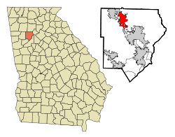 Location in Cobb County and the state of Georgia | |
 Kennesaw  Kennesaw 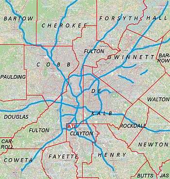 Kennesaw Location of Kennesaw in Metro Atlanta | |
| Coordinates: 34°1′24″N 84°36′55″W / 34.02333°N 84.61528°WCoordinates: 34°1′24″N 84°36′55″W / 34.02333°N 84.61528°W | |
| Country | United States |
| State | Georgia |
| County | Cobb |
| Incorporated | September 21, 1887 |
| Government | |
| • Mayor | Derek Easterling (R) |
| Area | |
| • Total | 9.5 sq mi (24.7 km2) |
| • Land | 9.4 sq mi (24.4 km2) |
| • Water | 0.1 sq mi (0.3 km2) |
| Elevation | 1,089 ft (332 m) |
| Population (2010) | |
| • Total | 29,783 |
| • Density | 3,155/sq mi (1,218.2/km2) |
| Time zone | EST (UTC-5) |
| • Summer (DST) | EDT (UTC-4) |
| ZIP code | 30144/30152 |
| Area code(s) | 770/678/470 |
| FIPS code | 13-43192[1] |
| GNIS feature ID | 0316387[2] |
| Website |
www |

Kennesaw is a city in Cobb County, Georgia, United States, located in the greater Atlanta metropolitan area. It had a population of 29,783 according to the 2010 census.[3] Founded in 1887, Kennesaw has a past surrounded with railroad history. During the Civil War, Kennesaw was the staging ground for the Great Locomotive Chase on April 12, 1862.
In 2007, the city was selected by Family Circle magazine as one of the nation's "10 best towns for families".[4] In 2009 Newsmax magazine listed the city among the "Top 25 Most Uniquely American Cities and Towns".[5] The city is perhaps best known nationally for its mandatory gun-possession ordinance.[6]
History
Etymology
As the Western and Atlantic Railroad was being built in the late 1830s, shanties arose to house the workers. These were near a big spring. A grade up from the Etowah River became known as "the big grade to the shanties", then "Big Shanty Grade", and finally "Big Shanty".[7]
The name "Kennesaw" is derived from the Cherokee word gah-nee-sah, meaning cemetery or burial ground.[8]
Civil War and after
Camp MacDonald, a training camp, was located there from 1861-1863.[9]
During the Civil War, Big Shanty was the site of major fighting in the Battle of Kennesaw Mountain, part of the larger Atlanta Campaign. Kennesaw Mountain National Battlefield Park,[10] located southeast of the city limits, now contains many of these historic areas, though much of the surrounding land has been developed, and some buried artifacts have been taken by people with metal detectors.
L.C. Chalker purchased a 1.25-acre (0.51 ha) tract of land adjacent to the Kennesaw Cemetery from J.W. Ellis in 1934, which was sold for burial purposes. Chalker purchased another 1 acre (0.40 ha) adjacent to the first parcel in 1948, which was also to be used for a cemetery. The Chalker family managed these portions of the cemetery until they were sold to the City of Kennesaw in the mid 1950s. The earliest known burial is the infant Lucius B. Summers, who was interred in 1863. Other grave markers date as far back as the 1860s to the 1890s. Civil War veterans are buried here. The cemetery is still in use.
The Southern Museum of Civil War and Locomotive History[11] is located downtown, next to the Western and Atlantic Railroad tracks on Cherokee Street, just off Main Street (old U.S. 41 and State Route 3). The museum is the current preservation and display location for The General, the locomotive that played the key role in the Great Locomotive Chase (The Texas which chased it is at the Atlanta Cyclorama).
In March 2004, First Lady Laura Bush designated Kennesaw a Preserve America Community.[12]
Geography
Kennesaw is located in northwestern Cobb County, bordered by the city of Acworth to the northwest. Kennesaw Mountain is located southeast of the city limits in the battlefield park. Its summit is the highest point in the Atlanta metro area, at an elevation of 1,808 feet (551 m) above sea level. The city was renamed for the mountain.
U.S. Route 41 and State Route 3 pass through the city as Cobb Parkway, leading southeast 7 miles (11 km) to Marietta and northwest 17 miles (27 km) to Cartersville. Interstate 75 passes just northeast of the city limits, with access from exits 269, 271, and 273. Via I-75, downtown Atlanta is 27 miles (43 km) to the southeast.
According to the United States Census Bureau, Kennesaw has a total area of 9.5 square miles (24.7 km2), of which 9.4 square miles (24.4 km2) is land and 0.12 square miles (0.3 km2), or 1.08%, is water.[3]
Climate
Kennesaw has a humid subtropical climate (Köppen climate classification Cfa).
| Climate data for Kennesaw, Georgia | |||||||||||||
|---|---|---|---|---|---|---|---|---|---|---|---|---|---|
| Month | Jan | Feb | Mar | Apr | May | Jun | Jul | Aug | Sep | Oct | Nov | Dec | Year |
| Record high °F (°C) | 80 (27) |
80 (27) |
89 (32) |
93 (34) |
96 (36) |
101 (38) |
104 (40) |
104 (40) |
99 (37) |
92 (33) |
86 (30) |
80 (27) |
104 (40) |
| Average high °F (°C) | 52 (11) |
56 (13) |
64 (18) |
73 (23) |
80 (27) |
87 (31) |
89 (32) |
88 (31) |
83 (28) |
73 (23) |
64 (18) |
54 (12) |
71.9 (22.3) |
| Average low °F (°C) | 30 (−1) |
33 (1) |
39 (4) |
46 (8) |
55 (13) |
64 (18) |
68 (20) |
67 (19) |
60 (16) |
48 (9) |
39 (4) |
32 (0) |
48.4 (9.3) |
| Record low °F (°C) | −12 (−24) |
−2 (−19) |
7 (−14) |
21 (−6) |
32 (0) |
40 (4) |
50 (10) |
48 (9) |
30 (−1) |
22 (−6) |
9 (−13) |
−4 (−20) |
−12 (−24) |
| Average precipitation inches (mm) | 4.86 (123.4) |
5.36 (136.1) |
5.07 (128.8) |
3.93 (99.8) |
4.12 (104.6) |
4.07 (103.4) |
5.10 (129.5) |
4.35 (110.5) |
4.10 (104.1) |
3.42 (86.9) |
4.30 (109.2) |
4.49 (114) |
54.63 (1,387.6) |
| Source: [13] | |||||||||||||
Demographics
| Historical population | |||
|---|---|---|---|
| Census | Pop. | %± | |
| 1880 | 244 | — | |
| 1890 | 168 | −31.1% | |
| 1900 | 320 | 90.5% | |
| 1910 | 573 | 79.1% | |
| 1920 | 467 | −18.5% | |
| 1930 | 426 | −8.8% | |
| 1940 | 436 | 2.3% | |
| 1950 | 564 | 29.4% | |
| 1960 | 1,507 | 167.2% | |
| 1970 | 3,548 | 135.4% | |
| 1980 | 5,095 | 43.6% | |
| 1990 | 8,936 | 75.4% | |
| 2000 | 21,675 | 142.6% | |
| 2010 | 29,783 | 37.4% | |
| Est. 2015 | 33,584 | [14] | 12.8% |
As of the census[1] of 2010, there were 29,783 people, 11,413 households, and 7,375 families residing in the city. There were 12,328 housing units at an average density of 1,027.3 per square mile (396.6/km²). The racial makeup of the city was 58.9% White, 22.3% Black, 10.8% Hispanic or Latino of any race, 5.3% Asian, 0.4% Native American, 0.02% Pacific Islander (U.S. Census), 4.7% from other Race (U.S. Census), and 3.0% Non-Hispanic Mixed of two or more races.
There were 11,413 households out of which 38.1% had children under the age of 18 living with them, 45.0% were married couples living together, 15.2% had a female householder with no husband present, and 35.4% were non-families. 26.8% of all households were made up of individuals and 6.4% had someone living alone who was 65 years of age or older. The average household size was 2.59 and the average family size was 3.18.
In the city the population was spread out with 27.0% under the age of 18, 10.6% from 18 to 24, 33.2% from 25 to 44, 21.8% from 45 to 64, and 7.3% who were 65 years of age or older. The median age was 32 years. For every 100 females there were 95.6 males. For every 100 females age 18 and over, there were 89.7 males.
Economy
Personal income
The median income for a household in the city was $61,355 and the median income for a family was $75,465. Males had a median income of $46,953, versus $42,809 for females. The per capita income for the city was $27,165. About 8.2% of families and 11.1% of the population were below the poverty line, including 13.1% of those under age 18 and 13.3% of those age 65 or over.
Tourism
Several festivals are held annually. Every April the annual Big Shanty Festival displays over 200 arts and crafts booths along with 20 food booths downtown. Over 60,000 people from around North Georgia attend the festival. A parade starts the festival.[16][17]
Government
The city hall[18] is located downtown, just off Main Street (old U.S. 41 and State Route 3, later State Route 293). It contains the offices of mayor and city council, the city jail in the basement, and a small 9-1-1 call center and other offices. It is the public-safety answering point for the city of Kennesaw and the neighboring city of Acworth, and dispatches the separate police departments of both cities. Calls for fire services are relayed to and dispatched from Cobb County's 911 center,[19] and serviced by the Cobb County Fire Department, as neither city has its own fire department.
Wireless Internet in city parks
In 2008, the city of Kennesaw awarded a bid to Digitel Wireless for the implementation of city wireless Internet. In March 2008, the city of Kennesaw announced the grand opening of four new wireless areas: Swift-Cantrell Park and Adams Park, and the train depot area across from the Southern Museum of Civil War and Locomotive History. The city has also provided Wi-Fi in the Ben Robertson Community Center.[20]
Crime statistics
In 2001, violent crime rates were about 60% below national and state rates. Property crime rates were from 46-56% below national and state rates. From 1999 to 2011, Kennesaw crime statistics reported that both property and violent crimes had decreased, though from 2003 to 2008 the trend in both violent and property crime rates slightly increased.[21] The increase in crime rate overall is attributed to the population growth rate of 37.41%. The population growth rate is much higher than the state average rate of 18.34% and is much higher than the national average rate of 9.71%.[22]
County services
The Cobb County Public Library System operates a Kennesaw branch library. The Cobb County Police Department serves unincorporated areas, including the Town Center Area Community Improvement District and Kennesaw State University (in addition to KSU's own police).
Gun law
Kennesaw is noted for its unique firearms legislation in response to Morton Grove, Illinois' law mandating gun prohibition. In 1982 the city passed an ordinance [Sec 34-21][23]
(a) In order to provide for the emergency management of the city, and further in order to provide for and protect the safety, security and general welfare of the city and its inhabitants, every head of household residing in the city limits is required to maintain a firearm, together with ammunition therefore.(b) Exempt from the effect of this section are those heads of households who suffer a physical or mental disability which would prohibit them from using such a firearm. Further exempt from the effect of this section are those heads of households who are paupers or who conscientiously oppose maintaining firearms as a result of beliefs or religious doctrine, or persons convicted of a felony.

Local attractions
- Southern Museum of Civil War and Locomotive History
- Kennesaw Mountain National Battlefield Park consists of around 18 miles (29 km) of nature trails and historic Civil War battle sites.[24]
- The Kennesaw State University Museum of History and Holocaust Education[25]
- The Kennesaw State University Bentley Rare Book Room and Archives[26]
Education
Public schools are provided by the Cobb County School District, including Big Shanty Intermediate School.[27]
Elementary schools include Bullard,[28] Chalker,[29]Hayes,[30] Kennesaw,[31] and Lewis.[32]
Middle schools include Awtrey,[33] Lost Mountain,[34] McClure,[35] Palmer,[36] and Pine Mountain.[37]
High schools include Harrison High School,[38] Kennesaw Mountain,[39] North Cobb,[40] and Kennesaw Charter Science & Math Academy.[41]
Private schools include Sunbrook Academy at Legacy Park,[42] and Sunbrook Academy at Stilesboro.[43]
Kennesaw State University is located near the city and is part of the University System of Georgia.
Notable people
- Jesse James Dupree, lead singer of rock band Jackyl[44]
- Yan Kaminsky, NHL left winger[45]
- Sean O'Pry, model[46]
- Mathew Pitsch, Republican member of the Arkansas House of Representatives from Fort Smith since 2015; former resident of Kennesaw[47]
- Dansby Swanson, infielder for the Atlanta Braves
- Lucas Till, actor
- Brian Voss, professional ten-pin bowler on the PBA Tour[48]
- Ron Lester, actor of Varsity Blues fame [49]
- Caroline Cossey
References
- 1 2 "American FactFinder". United States Census Bureau. Retrieved 2008-01-31.
- ↑ "US Board on Geographic Names". United States Geological Survey. 2007-10-25. Retrieved 2008-01-31.
- 1 2 "Geographic Identifiers: 2010 Demographic Profile Data (G001): Kennesaw city, Georgia". U.S. Census Bureau, American Factfinder. Retrieved July 29, 2014.
- ↑ Family Circle, August 2007
- ↑ Greenberg, Peter. "Newsmax Magazine Rates the Top 25 Most Uniquely American Cities And Towns". Retrieved 18 January 2014.
- ↑ Kennesaw, where everyone is armed by law - FT.com
- ↑ "How Big Shanty Got Its Name". Trade Day News. Kennesaw, Georgia. April 23–24, 1977. p. 9.
- ↑ "Digital Commons Kennesaw". KSU.edu. 2014. Retrieved 2015-02-08.
- ↑ Georgia Forts: page 7
- ↑ "Kennesaw Mountain National Battlefield Park - Kennesaw Mountain National Battlefield Park". Nps.gov. Retrieved 2012-07-12.
- ↑ "The Southern Museum of Civil War and Locomotive History". Southernmuseum.org. Retrieved 2012-07-12.
- ↑ "Preserve America - Explore and Enjoy Our Heritage". Preserveamerica.gov. 2012-07-03. Retrieved 2012-07-12.
- ↑ "Monthly Averages for Kennesaw, GA (30152)".
- ↑ "Annual Estimates of the Resident Population for Incorporated Places: April 1, 2010 to July 1, 2015". Retrieved July 2, 2016.
- ↑ "Census of Population and Housing". Census.gov. Retrieved June 4, 2015.
- ↑ "JRM Management Services". Retrieved 2012-07-11.
- ↑ "Kennesaw.com".
- ↑ (34°01′24″N 84°37′00″W / 34.0233°N 84.6167°W)
- ↑ "911 Home Page". 911.cobbcountyga.gov. Retrieved 2012-07-12.
- ↑ "Kennesaw Wi-Fi". Kennesaw Wi-Fi. Retrieved 2012-07-12.
- ↑ "Kennesaw Crime Rate Report (Georgia)".
- ↑ "Kennesaw Population and Races (Georgia)".
- ↑ Municipal Code, Kennesaw, Georgia, Article II, Sec. 34-21. - Heads of households to maintain firearms.
- ↑ "USA Today Travel". Retrieved 2012-07-11.
- ↑ "Museum of History & Holocaust Education". Kennesaw.edu. Retrieved 2012-07-12.
- ↑ "About the Gallery | Archives, Rare Books & Records Management". Web.kennesaw.edu. Retrieved 2012-07-12.
- ↑ Big Shanty Intermediate School
- ↑ Bullard Elementary School
- ↑ Chalker Elementary School
- ↑ Hayes Elementary School
- ↑ Kennesaw Elementary School
- ↑ Lewis Elementary School
- ↑ Awtrey Middle School
- ↑ Lost Mountain Middle School
- ↑ McClure Middle School
- ↑ Palmer Middle School
- ↑ and Pine Mountain Middle School
- ↑
- ↑ Kennesaw Mountain High School
- ↑ North Cobb High School
- ↑ Kennesaw Charter Science & Math Academy
- ↑ Sunbrook Academy at Legacy Park
- ↑ Sunbrook Academy at Stilesboro
- ↑ Jesse James Dupree at AllMusic
- ↑ Thunder AAA Hockey Club powered by GOALLINE.ca
- ↑ Sean O'Pry - Model Profile - Photos & latest news
- ↑ "Mathew W. Pitsch". intelius.com. Retrieved April 9, 2015.
- ↑ "Exempt player bios at www.pba.com". Pba.com. Retrieved 2012-07-12.
- ↑ "Ron Lester". IMDb.com, Inc. Retrieved 13 September 2016.
External links
- City of Kennesaw official web site
- Kennesaw WiFi
- Kennesaw State University
- Municipal Code, Kennesaw, GA
Municipalities and communities of Cobb County, Georgia, United States | ||
|---|---|---|
| Cities | 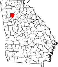 | |
| CDPs | ||
| Unincorporated communities | ||
| Footnotes | ‡This populated place also has portions in an adjacent county or counties | |
|  | |||||||
|
| ||||||||
| ||||||||
Template:Georgia
