Bhojpur District, Nepal
| Bhojpur rangpuri | |
|---|---|
| District | |
|
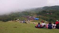
Chandi Bazar: a famous spot of Kirat Rai Ubhauli festival in Balankha | |
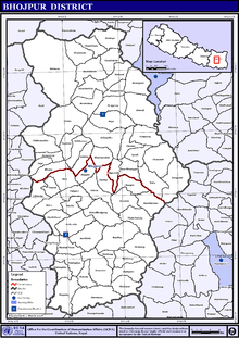
 Location of Bhojpur | |
| Country | Nepal |
| Region | Eastern (Purwanchal) |
| Zone | Kosi |
| Headquarters | Bhojpur |
| Area | |
| • Total | 1,507 km2 (582 sq mi) |
| Population (2011) | |
| • Total | 182,459[1] |
| Time zone | NPT (UTC+5:45) |
| Website |
www |
Bhojpur District (Nepali: भोजपुर जिल्ला![]() Listen ) is in Province No. 1 in eastern Nepal. The district's area is 1,507 km² with a population of 182,459 (2011).[1] The administrative center is Bhojpur.
Listen ) is in Province No. 1 in eastern Nepal. The district's area is 1,507 km² with a population of 182,459 (2011).[1] The administrative center is Bhojpur.
History
Classified as a Hill District, Bhojpur actually spans five of Nepal's eight climate zones.[2] 3% of the district's area is below 300 meters elevation in the Lower Tropical zone and 31% is Upper Tropical from 300 to 1,000 meters. 50% of the land area belongs to the Subtropical Zone between 1,000 and 2,000 meters and 15% is Temperate (2,000 to 3,000 meters). 2% rises higher into the Subalpine Zone.
Traditionally, the inhabitants of this area have been the indigenous Rai ethnic group; the Newar ethnic group being the main people in the Bhojpur town. Bhojpur forms part of Majh Kirat/Kirant (Middle Kirat). It is one of the richest districts in Nepal in biodiversity.
In the northern part of this district lies the beautiful small city of Dingla. Various hill castes, Brahmin (bahun in Nepali), Kshetriya (Chhettri in Nepali), and ethnic groups like Rai reside within this beautiful area. This is the place where rudraksha trees grow naturally in the forest as well as individually on people's land. The religious leader, women's rights activist and poet Yogmaya Neupane was born in 1860 in Dingla.
Champe is the other small town where people from surrounding villages come and sell their products. This happens every 15 days and is called Hatiya.
Balankha (Walangkha) is one of the growing towns in the southwest area of Bhojpur. Another town Ghoretar, southeast of Bhojpur, has been a center point of trade, education and administration for a long time. It is famous as Hatuwa Gadi "a powerful fort of Kirat king Sunahang" in Kirat history.
Balankha borders with neighboring Khotang district's Bopung village. Balankha is slowly emerging as another hub of education, communication, health and trade. The most distinctive thing about Balankha is its famous Chhongkha Sakela celebration. It is the Kirat Rai festival when Rais go to 'Sakewa Than' at Dammarkhu village of Khotang (across the river Buwa Khola), pray for good harvest and rain. Then they flock back to the open space of Chandi bazar to dance and celebrate with great joy.
Geography and climate
| Climate Zone[3] | Elevation Range | % of Area |
|---|---|---|
| Lower Tropical | below 300 meters (1,000 ft) | 2.7% |
| Upper Tropical | 300 to 1,000 meters 1,000 to 3,300 ft. |
30.5% |
| Subtropical | 1,000 to 2,000 meters 3,300 to 6,600 ft. |
49.8% |
| Temperate | 2,000 to 3,000 meters 6,400 to 9,800 ft. |
15.1% |
| Subalpine | 3,000 to 4,000 meters 9,800 to 13,100 ft. |
1.7% |
Towns and villages
2015 Nepal earthquake
The district was affected by an earthquake on 25 April 2015.[4]
See also
References
- 1 2 "National Population and Housing Census 2011(National Report)" (PDF). Central Bureau of Statistics. Government of Nepal. November 2012. Archived from the original (PDF) on 2013-04-18. Retrieved November 2012. Check date values in:
|access-date=(help) - ↑ The Map of Potential Vegetation of Nepal - a forestry/agroecological/biodiversity classification system (PDF), . Forest & Landscape Development and Environment Series 2-2005 and CFC-TIS Document Series No.110., 2005, ISBN 87-7903-210-9, retrieved Nov 22, 2013
- ↑ The Map of Potential Vegetation of Nepal - a forestry/agroecological/biodiversity classification system (PDF), . Forest & Landscape Development and Environment Series 2-2005 and CFC-TIS Document Series No.110., 2005, ISBN 87-7903-210-9, retrieved Nov 22, 2013
- ↑ "Nepal family finds starting over tough in wake of earthquake". nwi.com. The Times. 13 June 2015. Retrieved 21 June 2015.
Further reading
- "Districts of Nepal". Statoids.
External links
| Wikimedia Commons has media related to Bhojpur District, Nepal. |
Coordinates: 27°10′21″N 87°02′53″E / 27.17250°N 87.04806°E