Bhelupur, Varanasi
| Bhelupur भेलूपुर | |
|---|---|
| Suburb | |
|
Bhelupur, main road. (West to East view leading to Bhelupur Police Station). Picture taken from Water Works. Road is called "Kamachha Road" | |
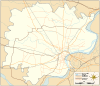 Bhelupur Area location on Varanasi district map | |
| Coordinates: 25°18′14″N 82°59′24″E / 25.303969°N 82.990008°ECoordinates: 25°18′14″N 82°59′24″E / 25.303969°N 82.990008°E | |
| Country |
|
| State | Uttar Pradesh |
| District | Varanasi |
| Government | |
| • Body | Varanasi Nagar Nigam |
| • M.P. |
Narendra Modi BJP[1](since 2014) |
| • M.L.A |
Jyotsana Srivastava BJP[2] (since 2012) Varanasi Cantonment |
| Elevation | 85 m (279 ft) |
| Languages | |
| • Official | Hindi |
| Time zone | IST (UTC+5:30) |
| Postal code | 221010 |
| Telephone code | +91-542 |
| Vehicle registration | UP65 XXXX |
| District website | Official website |

Bhelupur (a.k.a. Bhelupura) is a suburban neighborhood located in south of Varanasi district (Uttar Pradesh). It is situated 2.5 kilometers west of Kedar ghat and to the river Ganges. Benaras Hindu University is situated 4.5 kilometers south of Bhelupur.[3]
Bhelupur is bounded by Rathyatra in North, Lanka in South, Sonarpura in East and Sudamapur Bari Gaibi in the West.[4]
Places of importance
By the virtue of being a part of one of the oldest cities in the world (Varanasi), Bhelupur's history dates several hundred years back and houses several places of historical and touristic importance & interest.
- Tulsi Manas Mandir: This temple has both, historical as well as cultural importance in Hinduism. The ancient Hindu epic Ramcharitmanas was originally written at this place by Hindu poet-saint, reformer and philosopher Sri Tulsidas. In 1964, a temple (called Tulsi Manas Mandir) was built.[5]
- Durga Mandir & Durga Kund: Durga Temple is the temple for Goddess Durga and was built in the 18th century. The temple was constructed by Bengali Maharani (Bengali Queen) and has a pond (Kund) adjacent to it (hence the name "Durga Kund").[6]
- Vijayanagaram palace: Bhelupur houses the palace of Maharaja of Vijayanagaram. The palace is believed to be built in 18th century A.D. There is a residential colony called Vijay Nagar colony adjacent to the palace. Constructed in the 1970s, this colony is housed on the palace's compound and is reportedly one of the oldest in Varanasi.[7][8]
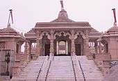
- Shri Digambar Jain Temple: Shri Digambar Jain Temple is the birthplace of Parshvanatha, the twenty-third Tirthankara of Jainism.[9][10][11]
- Central Hindu School: Established in 1898 by Dr. Annie Besant, Central Hindu School is India's one of the largest schools. From 1898 to 1916, this school conducted under graduation classes (as a loaner) for Banaras Hindu University (founded by Pandit Madan Mohan Malaviya) as the university was under construction during that time.[12]
- Shri Tilbhandeshwar Mahadev Mandir: Tilbhandeshwar Mahadev Mandir is one of the oldest and most famous temples in the holy city of Varanasi. This temple has great religious importance in Hinduism and is dedicated to the Lord Shiva.[13]
- Places of importance: Picture gallery
-

Durga Temple entrance
-

Durga Kund
-

Vijayanagaram palace
-

Vijayanagaram palace
-
Jain Mandir in Bhelupur
-

Bhelupur Police station
Education
Bhelupur has several schools and colleges; some dating back to the late 19th century.
- Central Hindu Boys School
- Central Hindu Girls School
- Vasant Kanya Mahavidyalaya.[14]
- C.M. Anglo Bengali Inter College.[15]
- Besant Theosophical School.[16]
Geography
Bhelupur is situated in centre of Varanasi city and South of Varanasi district. Kamchchha, Gurubaugh, Ashfaq Nagar, Khojwan, Gurudham colony, Jawahar Nagar colony, Padampuri colony, Ravindra Puri and Durga Kund are a part of Bhelupur jurisdiction.
 |
Varanasi Railway Station | Chaukaghat | Sarnath | |
| Lohta | |
Ganges | ||
| ||||
| | ||||
| DLW | Benaras Hindu University | Ramnagar |
Transportation
Bhelupur is served by Varanasi railway station (3 kilometers) and Varanasi airport (21 kilometers).
References
- ↑ "Comprehensive Election results". Election Commission of India website. Retrieved Feb 2015. Check date values in:
|access-date=(help) - ↑ "Varanasi North Result". elections.in. Retrieved Feb 2015. Check date values in:
|access-date=(help) - ↑ "Coordinates". latlong.net. Retrieved Feb 2015. Check date values in:
|access-date=(help) - ↑ "Span". Google Maps. Retrieved Feb 2015. Check date values in:
|access-date=(help) - ↑ "Tulsi Manas Mandir". Varanasi city website. Retrieved Feb 2015. Check date values in:
|access-date=(help) - ↑ "Durga Temple". Varanasi city website. Retrieved Feb 2015. Check date values in:
|access-date=(help) - ↑ "Vijayanagaram". Wikimapia. Retrieved Feb 2015. Check date values in:
|access-date=(help) - ↑ "Vijaya Nagar colony". Wikimapia. Retrieved Feb 2015. Check date values in:
|access-date=(help) - ↑ "Jain temples". yatratojaintemples.com. Retrieved Feb 2015. Check date values in:
|access-date=(help) - ↑ "Jain temples in Varanasi". jaintemple.in. Retrieved Feb 2015. Check date values in:
|access-date=(help) - ↑ "Bhelupur teerth". Jain Jagat. Retrieved Feb 2015. Check date values in:
|access-date=(help) - ↑ Brief History of Central Hindu College, Banaras Hindu University Dr. Rajendra Prasad, Correspondence and Select Documents, by Rajendra Prasad, Valmiki Choudhary. Allied Publishers, 1984. ISBN 81-7023-002-0. Page 479.
- ↑ "Temple information". Varanasi.org. Retrieved Mar 2015. Check date values in:
|access-date=(help) - ↑ "VKM". School website. Retrieved Feb 2015. Check date values in:
|access-date=(help) - ↑ "Anglo Bengali". Varanasi city website. Retrieved Feb 2015. Check date values in:
|access-date=(help) - ↑ "Besant Theosophical School". The Times of India. Retrieved Feb 2015. Check date values in:
|access-date=(help)
| Topics | |
|---|---|
| Regions | |
| Divisions | |
| Districts |
|
| Major cities | |
| Villages |
|
Portal: Uttar Pradesh | |