Bathinda
| Bathinda ਬਠਿੰਡਾ | |
|---|---|
| City | |
|
Qila Mubarak,the landmark of Bathinda City | |
 Bathinda  Bathinda | |
| Coordinates: 30°13′48″N 74°57′07″E / 30.23000°N 74.95194°ECoordinates: 30°13′48″N 74°57′07″E / 30.23000°N 74.95194°E | |
| Country | India |
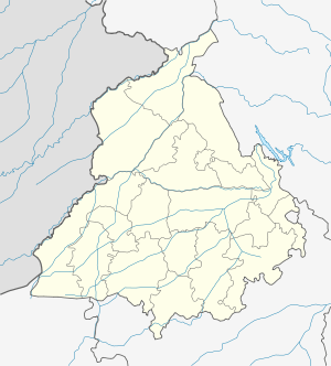
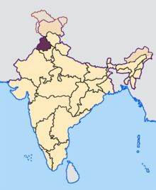
| State | Punjab |
| District | Bathinda |
| Government | |
| • Body | Municipal Corporation |
| • Commissioner | Sh. Anil Garg |
| • Member of Parliament | Harsimrat Kaur Badal (Shiromani Akali Dal) |
| • Mayor | Sh. Balwant Rai Nath |
| Elevation | 210 m (690 ft) |
| Population (2011) | |
| • Total | 499,217 |
| • Rank | 5th in Punjab |
| Languages | |
| • Official | Punjabi |
| Time zone | IST (UTC+5:30) |
| PIN | 15100X |
| Telephone code | +91-164-XXX XXXX |
| Vehicle registration | PB 03 |
| Railways Stations in City | Bathinda railway station |
| Website |
www |
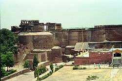
Bathinda (Punjabi: ਬਠਿੰਡਾ) (Hindi: बठिंडा) (known by Invaders as Tabar-e-Hind or Tabarhindh meaning the Gateway to India) is a city and Municipal Corporation in Southern part of Punjab.The city, named after the Bhati kings, is one of the oldest cities in Punjab, India and the current administrative headquarters of Bathinda District. It is in northwestern India in the Malwa Region, 227 km west of the capital city of Chandigarh and is the fifth largest city of Punjab. Bathinda's nicknamed the 'City of Lakes', courtesy of the artificial lakes in the city.The first empress of India, Razia Sultan was imprisoned in the Qila Mubarak fort in Bathinda.[1]
Bathinda is a home of Central University of Punjab and upcoming AIIMS. Bathinda is home to two modern thermal power plants, Guru Nanak Dev Thermal Plant and Guru Hargobind Thermal Plant at Lehra Mohabbat.[2] The city has a fertilizer plant,[3] a large oil refinery,Bathinda is home of two cement plants, Ambuja Cements and UltraTech Cement Limited. A zoo,[2] and a historic Qila Mubarak fort.[4] Bathinda is one of the largest food grain and cotton markets in northern India; the area around Bathinda is a prolific grape growing area. It is one of the leading cities in education in Punjab.[5]
Three national highways, NH 7 (Fazilka - Badrinath National Highway) and NH-54 (Dabwali - Pathankot National Highway) and NH 148B Bathinda to Narnaul (according to the new numbering of highways) pass through the city.[6]
History
Bhatinda was changed to Bathinda to conform to the phonetical expression as locally pronounced.[7] According to Henry George Raverty, Bathinda was known as Tabarhindh (Labb-ut-Twarikh). The earliest mention of Tabarhindh occurs in the Jami-Ul-Hakayat written about 607 Hijri or 1211 AD.
In 1004, Mahmud of Ghazni besieged the local fort, which was located on the route from the northwest into the rich Ganges valley.
In 1189, Muhammad Ghori attacked and occupied the fort of Bathinda. Prithvi Raj Chauhan, the ruler of this region, managed to recover possession of the fort thirteen months later in 1191 after the first battle of Tarain.
In circa 1754, the town was conquered by Maharaja Ala Singh, the Maharaja of Patiala and since then it followed the history of erstwhile princely state of Patiala. With the dawn of independence and merger of Patiala and East Punjab States into a division called PEPSU, Bathinda become a full-fledged district with headquarters at Bathinda city.[7]
Demographics
As per provisional reports of Census India, population of Bathinda city in 2011 is 285,813; male and female are 151,782 and 134,031 respectively. The sex ratio of Bathinda city is 883 per 1000 males.
The number of literate people in Bathinda city are 211,318 of which 118,888 are males while 92,430 are females, average literacy rate is 82.84 percent of which male and female literacy is 87.86 and 77.16 percent respectively.
Total children (ages 0 to 6) in Bathinda city are 30,713: 16,472 boys and 14,241 girls. Child sex ratio of girls is 865 per 1000 boys.[8]
Hinduism is the majority religion in Bathinda city with 62.61% people following the faith. Sikhism is the second most popular religion in the city which is followed by 35.04% of the people. Minorities are Muslims, Christians, Budhists and Jains.
Sikhs count for 70.89% of the population in Bathinda District on a whole in spite of not being a majority in the city.[9]
Geography and climate
Bathinda is in the northwestern region of India and is a part of the Indo-Gangetic alluvial plains. The exact cartographic co-ordinates of Bathinda are 30°12′N 74°57′E / 30.20°N 74.95°E.[11] It has an average elevation of 201 metres (660 ft).
| Bathinda | ||||||||||||||||||||||||||||||||||||||||||||||||||||||||||||
|---|---|---|---|---|---|---|---|---|---|---|---|---|---|---|---|---|---|---|---|---|---|---|---|---|---|---|---|---|---|---|---|---|---|---|---|---|---|---|---|---|---|---|---|---|---|---|---|---|---|---|---|---|---|---|---|---|---|---|---|---|
| Climate chart (explanation) | ||||||||||||||||||||||||||||||||||||||||||||||||||||||||||||
| ||||||||||||||||||||||||||||||||||||||||||||||||||||||||||||
| ||||||||||||||||||||||||||||||||||||||||||||||||||||||||||||
Bathinda's climate correspond to semi arid with high variation between summer and winter temperatures. Average annual rainfall is in a range of 20 mm to 40 mm.[12]
In recent times, Summer temperaures of 49 °C (120 °F)[13] and winter temperatures of 1 °C (about 33 °F)[14] were not unknown in Bathinda, lowest being -1.4 °C (29.48 °F) in the winter of 2013[15]
Economy
Major industries in Bathinda include National Fertilizers Plant,Bathinda is home of two cement plants, Ambuja Cements and UltraTech Cement Limited. Two power plants (Guru Nanak Dev Thermal Plant and Guru Hargobind Thermal Plant) (Lehra Mohabbat), Petrochemical Plants, Yarn & Textiles Plants, Citrus Fruit Belts and Sugar Mills. HMEL is building a Grassroots oil refinery [16] in Bathinda.
Suburbs In Bathinda
- Bhucho Mandi 10 km
- Goniana 10 km
- Maur Mandi 35 km
- Rampura Phul 20 km
- Talwandi Sabo 28 km
- Raman 34 km
- Sangat, India 34 km
Environment
There has been increasing incidence of various types of cancer in and around Bathinda. It is attributed to the presence of polluting industries and the indiscriminate use of modern pesticides and other toxic materials in farming. A 2007 epidemiological study found that the surface waters of Bathinda are contaminated with arsenic, cadmium, chromium, selenium and mercury primarily due to the discharge of untreated waste water from surrounding industries. Unscientific farming practices, that emerged after the introduction of Green Revolution, are also alleged to be a reason for growing incidence of not just cancer but also, high rates of spontaneous abortions, reproductive aliments, genetic deformities, anaemia, diarrhoea, vomiting, fluorosis and a host of skin ailments including rashes and boils. Many young couples are also reported to be migrating out to save their children from adverse effects. Hence the government has completey banned the use of ground water in the city for drinking purposes.[17]
Education
School Education
The city has many prestigious school chains too S.S.D. Senior Secondary School (Boys) is one of the oldest educational institutes and many English medium schools have also come up in the city during the last 30 years. The city also has DAV College which offers various Graduation and Post Graduation Courses.[18] St. Paul's High School is one and only school affiliated to ICSE board. DAV Public School and Delhi Public School have opened their branches in the city. Many missionary schools are being run in the city, such as St. Joseph's Convent Secondary School and St. Xavier's Senior Secondary School.
Central University of Punjab
The Central University of Punjab Bathinda (Punjab) has been established through the Central Universities Act 2009 which received the assent of the President of India on 20 March 2009. Its territorial jurisdiction extends to the whole State of Punjab.
It started its functioning from Camp Office in April, 2009, which happens to be the residence of the Vice Chancellor, and from November 2009 it shifted to its City Campus spread over an area of 35 acres. Construction of the main campus has started on 500 acres of land in Ghuda Village (21.5 km from Bathinda ISBT) on Badal Road. Engineers India Limited, a Navratna Public Sector Undertaking, is providing PMC services for the project.[19]
Shopping and Entertainment Center
- City Center Mall — Built by Amravati Infrastructure in collaborated with the Satya Group, this is the city's first mall.[20] It is designed by India 's ace architect Mr. Mohit Gujral.[21] The mall is spread across 1,00,000 sqr. ft. space.[22]
- Mittal's City Mall — Built by Ganpati Township ltd, it is considered to be an entertainment and retail project.[23] City Mall is spread over 3 lakh square feet and it has 8 floors.[24]
- Peninsula Mall — Built by HBN group the mall consists of around 2,50,000 sq. ft of retail space, sprawling across 5 floors with a view of lakes.[25]
See also
References
- ↑ "Raziya Sultan".
- 1 2 "Places to Visit".
- ↑ "Industry".
- ↑ "Archived copy". Archived from the original on 2011-07-19. Retrieved 2008-07-27.
- ↑ "Faridkot".
- ↑ "What is the basis by which National Highways are named in India? - Quora".
- 1 2 "District at A glance".
- ↑ "Census 2011".
- ↑ "Bathinda District Population Census 2011, Punjab literacy sex ratio and density".
- ↑ "Bathinda City Population Census 2011 - Punjab".
- ↑ "Maps, Weather, and Airports for Bhatinda, India".
- ↑ http://www.mapsofindia.com/ maps/india/annualrainfall.htm
- ↑ under the section 'historical monthly average for may', subsection 'temperature', http://www.myweather2.com/City-Town/India/Bhatinda/climate-profile.aspx?month=5
- ↑ under the section 'historical monthly average for Jan', subsection 'temperature', http://www.myweather2.com/City-Town/India/Bhatinda/climate-profile.aspx?month=1
- ↑ A news report, "Archived copy". Archived from the original on 2014-05-31. Retrieved 2014-05-30.
- ↑ "Archived copy". Archived from the original on 2009-12-07. Retrieved 2009-11-02.
- ↑ "Cancer Bathinda's dubious distinction". 6 September 2011 – via The Hindu.
- ↑ "Welcome to DAV College, Bathinda.".
- ↑ http://www.cup.ac.in/publications/newsletter_vol.1%3B%20no.3%3B%20august-october2013.pdf
- ↑ "Amravati".
- ↑ "How Mohit Gujral changed India's skyline".
- ↑ "Location Details of City Centre Mall Bathinda in India".
- ↑ "Location Details of Mittals City Mall Bathinda in India".
- ↑ "File Not Found".
- ↑ ":: Welcome to HBN Global ::".
External links
| Wikimedia Commons has media related to Bathinda. |
| Topics |
|  |
|---|---|---|
| Regions | ||
| Districts | ||
| Major Cities | ||