Bhadresar
| Bhadresar Bhadreshwar | |
|---|---|
| village | |
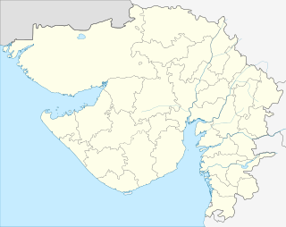 Bhadresar  Bhadresar Location in Gujarat, India | |
| Coordinates: 22°54′43″N 69°54′14″E / 22.91194°N 69.90389°ECoordinates: 22°54′43″N 69°54′14″E / 22.91194°N 69.90389°E | |
| Country |
|
| State | Gujarat |
| District | Kutch district |
| Population (2011) | |
| • Total | 4,552 |
| Languages | |
| • Official | Gujarati, Hindi |
| Time zone | IST (UTC+5:30) |
| PIN | 370410 |
| Vehicle registration | starting with GJ 12 |
| Sex ratio | 1000/916 ♂/♀ |
Bhadresar or Bhadreshwar /bəˈdrɛswər/ is a village in Mundra Taluka, Kutch district of Gujarat, India.[1] It is about 27 km from Taluka headquarters Mundra and barely a kilometer away from seashore.[2]
History
Bhadresar is the site of the ancient city of Bhadravati. Most of the ruins have been carried away, even the foundations having been dug up for building stone.[3][4] Bhadravati is mentioned in epic Mahabharata.[5] It is mentioned in works of Kantavijay, a Jain monk.[6]
The earliest source of information regarding place is an inscription on the Ajitnath statue in Vasai Jain temple which records Samvat 622 (555 AD) which may be marking Samvat 1622 (1565 AD) also. The Vasai Jain Temple is said to have been founded in the 21st year of the Vairat era, and dedicated to Vasai by Siddhasen of the race of Hari. His successors were Mahasen, Narsen, Bhojraj, Vanraj, Sarangdev, Virasen, Harisen, who lived in the time of Vikram (57 BC). Harisen had left his kingdom to his widow Lilavati. Lilavati was succeeded by his nephew Kirtidhara. Then came Dharnipal, Devdatt and Danjiraj. In time of Dhaniraj, the country was plundered by many chiefs.[6]
In 156, (Samvat 213), Vanraj Vaghela of Munjpur, who was Jain seized the country. He was succeeded by Yograj, Ratnadatta or Shivaditya and Vijayarao or Vaisiddha. Next, after a time of misrule, the Kathis of Pavargadh seized Bhadravati and kept it for 147 years. After them, 651 (Samvat 618), Kanak Chavda of Patan took the country, built the temple, and in 555 (Samvat 622) set up the statue of Ajitnath which may be brought in to fit the date on the statue. Kanak's successor was Akad Chavda, a Shaiva. During his time, the village was invaded by Sayyid Lal Shah and Mughuls. He was followed by his son Bhuvad who lost his kingdom to the Solanki Rajputs of Bhangadh. The new rulers changed the name of the place to Bhadreshwar in 741 (Samvat 798), and continued to hold it till 1132 (Samvat 1189). Navghan, the son of Bhimrao, was last of them.[4][6][3][7]
The other statues of Jain temple marks Samvat 1232 (1175 AD) as their dates. Perhaps the earliest historical fact is that in Samvat 1182 (1125 AD), Jagdusha, a Jain merchant and philanthropist who had made a fortune as a grain dealer in a time of famine, received a grant of Bhadresar and had the temple so thoroughly repaired that all traces of antiquity were removed. He died without heirs in 1181 (Samvat 1238) and the village fell into the hands Naughan Vaghela and his vakils Ajjaramal Shantidas and Nagandas Tejpal. Vastupal-Tejapal, the ministers in court of Viradhaval of Vaghela dynasty visited the temple with Sangha in Samvat 1286 and was well received by Navghan. They managed to convince Viradhaval to get his daughter married with Sarangdev, the grandson of Navghan. In the twelfth and thirteenth centuries was a most popular place of pilgrimage among Jains.[6]
Under the Jadejas, it was seized by Jam Hala and afterwards by Jam Raval in 1535 (Samvat 1592). Hala Dungarji, the relation of Rao Bharmalji, seized the temple-lands and Rao had to visit in Samavat 1659 to arrange matters between Jains and him. In 1693, it was plundered by a Muslim forces led by Mohsum Beg and many of the images were broken. Since then it has been neglected. In 1763, the walls of the old fort began to be pulled down and the stones used for building, and about 1810 even the old temples were razed to supply stones to build the seaport town of Mundra.[4][6]
On 15 December 1815, the army of Cutch State was defeated near Bhadresar. The armies of British East India Company was led by Colonel East and the army of Cutch was led by a Muslim commander, Hussain Miyan met near Bhadresar. The British army was behind the Vasai Jain Temple and temple was coming in between them. Husain Miyan respected the sanctity of temple and he didn’t fire on British, fearing temples might be damaged. The British army won and occupied the fortified town of Anjar, port of Tuna and adjacent villages by 25 December 1815. This led to negotiations between rulers of Cutch and British. The Jadeja rulers of Kutch accepted the suzerainty of British in 1818 and Captain James MacMurdo was posted as British Political Resident stationed at Bhuj. The Anjar district, however, remained under direct occupation of British forces for seven years till 25 December 1822, when it handed back to Cutch State by an agreement.[8][9]
After independence of India in 1947, Cutch State acceded unto the dominion of India and was constituted an independent commissionaire, Kutch State. In 1956, Kutch State was merged with Bombay state, which in 1960 was divided into the new linguistic states of Gujarat and Maharashtra, with Kutch becoming part of Gujarat state. Bhadresar now falls under Mundra Taluka of Kutch district.
Places of interest
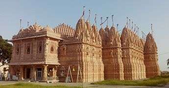
Vasai Jain Temple
Vasai Jain Temple is believed to be one of the oldest Jain temples in India, although they have been renovated and rehabilitated from time to time.[2] It is said a Jain layman named Devchandra laid the foundation stone of this temple centuries ago.[5] In year 1125, the temple was renovated extensively by Jagdusha.[3][5][7][4] The temples have been destroyed many times due to natural calamities like earthquakes and the chronicles of Mistris of Kutch, mention that they were the architects and artisans, who renovated temples during the earthquakes of 1819, 1844–45 and 1875.[10][11][8][6]
In former temple, the lower part was considered the oldest in age, perhaps about 1170. The temple complex was expanded with the corridors, then the outer wings, then the shrine, and last of all the porch.[4] The temple complex was again completely devastated in earthquake of 26 January 2001, however, it has now been completely rebuilt to as many of the old shrines were destroyed to the extent that it could not be rehabilitated.[2][6][12][13][14][15]
The general plan is like that of the Dilwara Temples on mount Abu. It stands in a court about 48 feet wide by 85 long, surrounded by a row of forty-four shrines with a corridor in front. The temple stands in a courtyard, which, from the line of the temple front, is covered by three pillared domes. The temple, facing the east, is entered by a flight of steps that rise from the outer door to the covered area in front of the sanctuary. Over the porch is another large dome covering an area separated by a low screen wall from the area of the entrance hall, mandap, between it and the front of the temple itself. At the south-west corner and behind the cells on the left side is a row of chambers with cellars entered by lifting up flagstones in the floor. In the shrine are three white marble images. The central image is Ajitnath, the second of the Tirthankars, with the date 622 probably for Samvat 1622 or AD 1565. On his right is Parshwanath with the snake hood marked 1175 (Samvat 1232), and on his left Santinath, the 16th Tirthankar, also marked 1175 (Samvat 1232) . On the extreme right is the image of the black or Shamla Parshwanath.[4][6]
Mosque ruins

On the south of Vasai Jain temple, there are ruins of large mosque nearly buried in the sand. It has been built with large stones. The pillars are square at base, octagon in the middle and circular above having bracket capitals above to support lintels which are 9 feet long. In the front of Mehrab, there are two rows of pillars in good condition followed by two rows of pillars with disturbed condition. It followed by wall and four more rows of pillars and some other pillars, probably of porch.[6]
Lal Shahbaz Dargah
Pir Lal Shahbaz Dargah, in a small walled enclosure, has a square pyramid shaped dome, round in the inside and supported on eight pillars set against the wall. The roof of the porch is flat is divided in 9×3 small squares, each with lotus flowers inside. Round the architrave, above the vine-ornamented wall-head course, there is a deep line of Arab inscription in large square Kufic characters, and on the right-end of the wall there are two lines of inscription. In the court some graves also have Kufic inscriptions. These epigraph constructed in 1160 marked the first use of Kufic script in India.[4][6][16]
Duda Masjid
Duda Masjid is very old mosque which is reliably dated to the late 12th century, meaning they predate the well known Islamic architecture of Ahmedabad by 250 years or so, making them in all likelihood the first mosques built in India.[3][2]
On South-west from Lal Shahbaz Dargah is an another mosque; now entered from the north side, but the original entrance is on the east side, Within which is built a small chamber, apparently never finished. The porch is raised on eight pillars, with pilasters against the walls. At the back is a Mehrab, a plain semi-circular recess, and two neat doors leading into an inner apartment, possibly a second place of prayer for a select number. It has four doors, two at each end. This mosque is built of pretty large stones, most accurately jointed, and all the roofs are of flat slabs. The doors have drips over them, and the two into the front apartment have semi-circular arches, the others lintels. The architraves are carved with neat veli or creeper patterns and with large flowers below.[6]
Duda Stepwell

Duda Vav is a large and substantial though plain step-well with a lintel about 17 feet 7 inches long by 2 feet 1 inches square. It was constructed by placing heavy blocks of stones on one another. The stepwell is now partially collapsed and is ruined. There was a dome of Shiva Temple near it in 1850s. It was 15 feet 18 1⁄2 inches overall and pillars are 1 foot 4 inches long.[4][6]
Chokhanda Mahadev Temple

There is also an ancient Shiva temple known as Chokhanda Mahadev situated at the sea-shore and the big square step well known as the Pandavs Kund said to build by the Pandavas 5000 years ago.[3] This old temple was made with red stones which was also destroyed in 2001 earthquake and has now been completely rebuilt.[13] Besides there are also centuries old Rokadiya Hanuman temple.
Economy
Majority of population relies on fishery.
There is a thermal power plant by OPG Power.[1][17] The Bhadresar has been included in special economic zone of Mundra. However, the local fisherman and other communities have protested the development and there is resentment that the traditional livelihoods of residents in the area have also been affected by the new industrial projects, leading to organized protests.[18][19][20]
References
- 1 2 CSE analyses: EIA report of thermal power project, Bhadreshwar, Kutch, Gujarat
- 1 2 3 4 "Bhadreshwar". Gujarat Tourism, Government of Gujatat. Retrieved 30 January 2014.
- 1 2 3 4 5 Bhadreshwar Temple
- 1 2 3 4 5 6 7 8 Gazetteer of the Bombay Presidency: Cutch, Palanpur, and Mahi Kantha (Public Domain text). Printed at the Government Central Press. 1880. pp. 213–215.
- 1 2 3
- 1 2 3 4 5 6 7 8 9 10 11 12 James Burgess (1876). Report on the Antiquities of Kutch & Kathiawar: Being the Result of the Second Season's Operations of the Archaeological Survey of Western India, 1874-1875. London: India Museum. pp. 205–210. Archived from the original on 2015. Retrieved 27 August 2016.
- 1 2 Gujarat Guide : Kutch
- 1 2 Kutch Gurjar Kshatriya Samaj : A brief History & Glory : by Raja Pawan Jethwa. (2007) Calcutta.
- ↑ Glimpse of Anjar, Kutch
- ↑ Kadia Kashtriya Itihas. Published in 1896.
- ↑ Nanji Bapa ni Nondh-pothi Gujarati book,1999 Vadodara. It is a diary of Railway Contracts done by KGK community noted by Nanji Govindji Tank. This book was given Aank Sidhhi award by Kutch Shakti at Mumbai in year 2000. The book has year wise details of Railway lines built by Mistris of Kutch and has a section with photos on Historical Monuments & Architects built by Mistris of Kutch.
- ↑ Newly Built Bhadreshwar Jain Tirth , Kutch
- 1 2 Vasai Jain Tirth, Bhadreswar
- ↑ Photo of old Bhadreshwar Jain Temple Old Jain Temple, with rubble of structure destroyed in earthquake, which can be seen.
- ↑ 53 Jinalaya Temple of Bhadreshwar Tirth (Construction)
- ↑ Shastri, Parth (24 February 2012). "Epigraphs from Sultanate period in Guj show integration of faiths". The Times of India. Retrieved 14 December 2014.
- ↑ Adani Power Announces Project Financing of $2,719m For Bhadreswar Coal Fired Power Plant In Gujarat, India - Banking on India Power Needs Archived 23 March 2012 at the Wayback Machine.
- ↑ A visit to the coastal areas adjoining the Mundra port in the Kutch reveals discontent among fisherfolk, traders and pastoralists over the creation of a special economic zone in the area. Apart from environmental concerns, the traditional livelihoods of residents in the area have also been affected by the new industrial projects, leading to organised protests, as witnessed in Bhadreswar village a few months ago. Development and Displacement: Resentment in the Kutch (20 February 2010)
- ↑ Fisher Woman Speaks in the campaign Meeting of Leaders of fishing villages at Bhadreswar, Kutch. he story of the land acquisition is itself a pointer to the apathy of the government for conservation and their leaning to big business. The coastal stretch of Mundra had creeks and thick mangrove vegetation even five years back. The business houses first started putting up bunds through their henchmen blocking inflow of sea water. This was a blatant violation of CRZ regulation. The blockage of water inflow killed large parts of the mangroves. Then the business houses moved in to secure formal lease from the government claiming it as waste land.
- ↑ Adani Power awaits environ min nod for Bhadreshwar plant 24 December 2010
- This article contains Public Domain text from Gazetteer of the Bombay Presidency: Cutch, Palanpur, and Mahi Kantha. Printed at the Government Central Press. 1880. pp. 213–215. and from James Burgess (1876). Report on the Antiquities of Kutch & Kathiawar: Being the Result of the Second Season's Operations of the Archaeological Survey of Western India, 1874-1875. London: India Museum. pp. 205–210. Archived from the original on 2015. Retrieved 27 August 2016.