Beverly Hills Post Office


Beverly Hills Post Office (BHPO) is the name given to a section of Los Angeles, California, that lies within the 90210 ZIP code, assigned to the Beverly Hills Post Office. Los Angeles mailing addresses with the ZIP code 90210 are written as "Beverly Hills, CA 90210", though the properties themselves lie outside of the Beverly Hills city limits.
History
The identification of the section with Beverly Hills did not begin until the 1960s. "When Beverly Hills was incorporated in 1914, the northern border was roughly a mile north of Sunset Boulevard, with the exception of Trousdale Estates. The remaining section stretching north to Mulholland Drive was left as part of the hills of Los Angeles, where it remained anonymous for decades." In 1963 the area was included within the 90210 ZIP Code, which also covers the northern part of Beverly Hills.[1]
Post Office
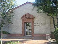
The ZIP Code 90210 is still handled by the Beverly Hills Main Post Office. The original Beverly Hills Main Post Office from 1934 to the 1990s still sits at 469 North Crescent Drive in the Beverly Hills Civic Center, and was added to the National Register of Historic Places in 1985.[2][3] In 1990, 325 North Maple Street was rebuilt as the new Beverly Hills Main Post Office; the old Main on Crescent Drive was closed in 1999 when the building was sold back to the City of Beverly Hills.[2][3] Beverly Hills has other Post Offices in other ZIP Codes as well.
City services
As citizens of the city of Los Angeles, BHPO residents receive Los Angeles city services and vote in Los Angeles elections. This can cause problems with emergency response. For example, when actress Demi Moore needed an ambulance in January 2012, Beverly Hills and Los Angeles 9-1-1 operators used over two minutes to determine jurisdiction for her home.[4]
Education
Public education is provided by the Los Angeles Unified School District[1] as opposed to the Beverly Hills Unified School District, which serves students within Beverly Hills city limits.
The western part of the Beverly Hills Post Office area is zoned to Warner Avenue Elementary School, while the eastern portion is zoned to West Hollywood Elementary School.
All residents are zoned to Emerson Middle School and University High School.
References
- 1 2 Spitz, H. May. Canyon homes and that famous ZIP code." Los Angeles Times, 11 July 2004.
- 1 2 "1932 Crescent Drive Post Office Historic Structure Report". Los Angeles: Hardy Holzman Pfeiffer Associates. July 2002. Retrieved 2015-06-18.
- 1 2 Ostashay, Jan (2012-10-03). "Re: LANDMARK ASSESSMENT CONFIRMATION REVIEW: U.S. Post Office, Beverly Hills Main Post Office, 469 North Crescent Drive (470 North Canon Drive), Beverly Hills, CA" (PDF). Long Beach, California. Retrieved 2015-06-17. Includes National Register of Historic Places Inventory - Nomination Form as attachment.
- ↑ "Dispatchers Taking Demi Moore's 911 Call Confused Over Who Should Respond". CBS News. 2012-01-27. Retrieved January 30, 2012.
| Topics |  | |
|---|---|---|
| Government | ||
34°4′20.9″N 118°24′6.65″W / 34.072472°N 118.4018472°WCoordinates: 34°4′20.9″N 118°24′6.65″W / 34.072472°N 118.4018472°W