Beverly Hills, Michigan
| Beverly Hills | |
|---|---|
| Village | |
| Village of Beverly Hills | |
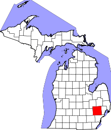
 Location of Beverly Hills within Oakland County, Michigan | |
| Coordinates: 42°31′19″N 83°14′32″W / 42.52194°N 83.24222°WCoordinates: 42°31′19″N 83°14′32″W / 42.52194°N 83.24222°W | |
| Country | United States |
| State | Michigan |
| County | Oakland |
| Government | |
| • President | Rosanne Koss |
| Area[1] | |
| • Village | 4.02 sq mi (10.41 km2) |
| • Land | 4.00 sq mi (10.36 km2) |
| • Water | 0.02 sq mi (0.05 km2) |
| Elevation | 728 ft (222 m) |
| Population (2010)[2] | |
| • Village | 10,267 |
| • Estimate (2012[3]) | 10,367 |
| • Density | 2,566.8/sq mi (991.0/km2) |
| • Metro | 4,296,250 |
| Time zone | EST (UTC-5) |
| • Summer (DST) | EDT (UTC-4) |
| ZIP code | 48025 |
| Area code(s) | 248 |
| FIPS code | 26-08160[4] |
| GNIS feature ID | 2398116[5] |
| Website | http://www.villagebeverlyhills.com |
Beverly Hills is a village in Southfield Township, Oakland County of the U.S. state of Michigan. It is a suburb of Detroit. As of the 2010 census, the population was 10,267[6] making it by far the most populous village in the state.[7]
History
Beverly Hills was established in 1958 as Westwood, indicating it was west of Woodward Avenue. It was renamed as Beverly Hills in 1959.[8]
Geography
According to the United States Census Bureau, the village has a total area of 4.02 square miles (10.41 km2), of which 4.00 square miles (10.36 km2) is land and 0.02 square miles (0.05 km2) is water,[1] most of which is the main branch of the Rouge River.
Demographics
| Historical population | |||
|---|---|---|---|
| Census | Pop. | %± | |
| 1960 | 8,633 | — | |
| 1970 | 13,598 | 57.5% | |
| 1980 | 11,598 | −14.7% | |
| 1990 | 10,610 | −8.5% | |
| 2000 | 10,437 | −1.6% | |
| 2010 | 10,267 | −1.6% | |
| Est. 2015 | 10,424 | [9] | 1.5% |
2010 census
As of the census[2] of 2010, there were 10,267 people, 4,038 households, and 2,888 families residing in the village. The population density was 2,566.8 inhabitants per square mile (991.0/km2). There were 4,212 housing units at an average density of 1,053.0 per square mile (406.6/km2). The racial makeup of the village was 89.2% White, 6.6% African American, 0.2% Native American, 2.0% Asian, 0.4% from other races, and 1.6% from two or more races. Hispanic or Latino of any race were 1.7% of the population.
There were 4,038 households of which 34.0% had children under the age of 18 living with them, 60.5% were married couples living together, 8.4% had a female householder with no husband present, 2.6% had a male householder with no wife present, and 28.5% were non-families. 24.7% of all households were made up of individuals and 11% had someone living alone who was 65 years of age or older. The average household size was 2.52 and the average family size was 3.04.
The median age in the village was 44.7 years. 25.1% of residents were under the age of 18; 5% were between the ages of 18 and 24; 20.5% were from 25 to 44; 32.1% were from 45 to 64; and 17.4% were 65 years of age or older. The gender makeup of the village was 47.8% male and 52.2% female.
2000 census
As of the census[4] of 2000, there were 10,437 people, 4,085 households, and 2,998 families residing in the village. The population density was 2,603.6 per square mile (1,004.9/km²). There were 4,196 housing units at an average density of 1,046.7 per square mile (404.0/km²). The racial makeup of the village was 93.21% White, 3.05% African American, 0.15% Native American, 1.85% Asian, 0.02% Pacific Islander, 0.29% from other races, and 1.44% from two or more races. Hispanic or Latino of any race were 1.41% of the population.
There were 4,085 households out of which 33.0% had children under the age of 18 living with them, 64.8% were married couples living together, 6.3% had a female householder with no husband present, and 26.6% were non-families. 23.6% of all households were made up of individuals and 10.8% had someone living alone who was 65 years of age or older. The average household size was 2.52 and the average family size was 3.01.
In the village the population was spread out with 24.6% under the age of 18, 4.0% from 18 to 24, 26.2% from 25 to 44, 26.1% from 45 to 64, and 19.1% who were 65 years of age or older. The median age was 42 years. For every 100 females there were 91.4 males. For every 100 females age 18 and over, there were 87.5 males.
The median income for a household in the village was $90,341, and the median income for a family was $102,223. Males had a median income of $80,283 versus $49,265 for females. The per capita income for the village was $43,452. About 1.7% of families and 2.3% of the population were below the poverty line, including 1.5% of those under age 18 and 2.1% of those age 65 or over.
Education
Beverly Hills is a part of the Birmingham Public School District. It is home to several public schools: Groves High School, Berkshire Middle School, Beverly Elementary, and Greenfield Elementary.
The upper school and administrative offices of the Detroit Country Day School, a private prep school, are in Beverly Hills. The school's middle school campus is also in Beverly Hills.[11]
The French School of Detroit holds its high school classes at Groves High School.[12] Beverly Elementary School provides classes for FSD elementary school students.[13]
Kensington Academy, a Catholic PK-8 school, previously had its campus in Beverly Hills.[14] In 2006 the school announced that it was merging into the Academy of the Sacred Heart.[15]
Recreation
- Beverly Park
- Beverly Hills Athletic Club - summer swim and tennis club
- Beverly Hills Club - indoor tennis and fitness club
- Beverly Hills Athletic Club - summer swim and tennis club
- chicken club-talking about cooking chicken and how to prepare it.
References
- 1 2 "US Gazetteer files 2010". United States Census Bureau. Archived from the original on 2012-07-14. Retrieved 2012-11-25.
- 1 2 "American FactFinder". United States Census Bureau. Retrieved 2012-11-25.
- ↑ "Population Estimates". United States Census Bureau. Archived from the original on 2013-06-17. Retrieved 2013-06-03.
- 1 2 "American FactFinder". United States Census Bureau. Archived from the original on 2013-09-11. Retrieved 2008-01-31.
- ↑ U.S. Geological Survey Geographic Names Information System: Beverly Hills, Michigan
- ↑ "Race, Hispanic or Latino, Age, and Housing Occupancy: 2010 Census Redistricting Data (Public Law 94-171) Summary File (QT-PL), Beverly Hills village, Michigan". U.S. Census Bureau, American FactFinder 2. Archived from the original on September 11, 2013. Retrieved August 19, 2011.
- ↑ Bromage, Arthur W. "Organization of City and Village Government of Michigan" (PDF). mml.com. Michigan Municipal League. Retrieved 16 February 2016.
- ↑ Water Romig, Michigan Place Names, p. 60
- ↑ "Annual Estimates of the Resident Population for Incorporated Places: April 1, 2010 to July 1, 2015". Retrieved July 2, 2016.
- ↑ "Census of Population and Housing". Census.gov. Archived from the original on May 11, 2015. Retrieved June 4, 2015.
- ↑ "Contact Us." Detroit Country Day School. Retrieved on September 13, 2009.
- ↑ "The High School." French School of Detroit. Retrieved on June 20, 2015. "Location: Groves High School, 20500 13 mile Road, Beverly, MI 48025."
- ↑ "Elementary." French School of Detroit. Retrieved on June 20, 2015.
- ↑ Home page (Archive). Kensington Academy. February 20, 2003. Retrieved on June 20, 2015. "Kensington Academy is at 32605 Bellvine Trail located south off 14 Mile Road between Lahser and Evergreen Roads in Beverly Hills."
- ↑ "ACADEMY OF THE SACRED HEART IN BLOOMFIELD HILLS AND KENSINGTON ACADEMY IN BEVERLY HILLS ANNOUNCE MERGER" (Archive). Academy of the Sacred Heart. July 31, 2006. Retrieved on April 16, 2015.
External links
| Topics |  | |
|---|---|---|
| Detroit | ||
| Municipalities over 80,000 | ||
| Municipalities 40,000 to 80,000 | ||
| Cultural enclaves | ||
| Satellite cities | ||
| Counties in MSA | ||
| Counties in CSA | ||