Beverly, Chicago
| Beverly | |
|---|---|
| Community area | |
| Community Area 72 - Beverly | |
 | |
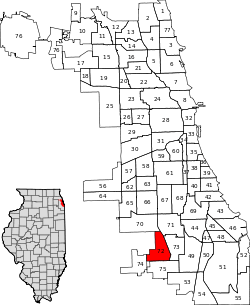 Location within the city of Chicago | |
| Coordinates: 41°42.6′N 87°40.8′W / 41.7100°N 87.6800°WCoordinates: 41°42.6′N 87°40.8′W / 41.7100°N 87.6800°W | |
| Country | United States |
| State | Illinois |
| County | Cook |
| City | Chicago |
| Neighborhoods |
list
|
| Area | |
| • Total | 3.20 sq mi (8.29 km2) |
| Population (2010) | |
| • Total | 20,034 |
| • Density | 6,300/sq mi (2,400/km2) |
| Demographics (2010)[1] | |
| • White | 58.82% |
| • Black | 34.13% |
| • Hispanic | 4.57% |
| • Asian | 0.56% |
| • Other | 1.92% |
| Time zone | CST (UTC-6) |
| • Summer (DST) | CDT (UTC-5) |
| ZIP Codes | Parts of 60620, 60643, 60655 |
| Median income[2] | $83,092 |
| Source: U.S. Census, Record Information Services | |
Beverly is one of the 77 community areas of Chicago, Illinois. It is located on the South Side on the southwestern edge of the city. The borders are (roughly) 87th Street on the north; Beverly Avenue, Hale Avenue and Vincennes Road on the east; 107th Street on the south; and Francisco Avenue and Western Avenue on the west. A segment of the eastern part of the Ridge Country Club lies with the boundaries of the community. Sparsely settled in the middle of the 19th century, Beverly began to be developed by business interests from Chicago[3] in the latter part of the nineteenth century, encouraged largely by the completion in 1889 of the suburban line of the Rock Island Railroad that runs parallel with the eastern edge of the Blue Island ridge (see the Ulrich & Son ad that appears elsewhere in this article). The natural beauty of its position on the ridge allowed the community to become an exclusive streetcar suburb, and the homes and large lots reflect this historic distinction. Beverly is located on the highest elevation in Chicago,[4] and is one of the most racially and ethnically diverse neighborhoods in the city.
Access
Beverly has quick access (by public transport or car) to all of the Chicago financial markets, shopping, airports, and attractions, yet retains itself as a peaceful and quiet wooded community. Beverly is one of the top five largest historic districts in any major city in the USA. The particular trains that are accessed by the Beverly community are provided from Metra's Rock Island line.[5]
North Blue Island
Beverly is one of few areas in the City of Chicago that features a hilly terrain. This geography is due to its location in the middle of the geological formation known as the Blue Island Ridge. In its early years of settlement this area as well as Morgan Park to the south was known as North Blue Island,[6] denoting its relationship to the village of Blue Island, which was settled in 1836 and is located a few miles to the south.
Ethnicity
| Historical population | |||
|---|---|---|---|
| Census | Pop. | %± | |
| 1930 | 13,793 | — | |
| 1940 | 15,910 | 15.3% | |
| 1950 | 20,186 | 26.9% | |
| 1960 | 24,814 | 22.9% | |
| 1970 | 26,797 | 8.0% | |
| 1980 | 23,360 | −12.8% | |
| 1990 | 22,385 | −4.2% | |
| 2000 | 21,992 | −1.8% | |
| 2010 | 20,034 | −8.9% | |
| [7] | |||
The neighborhood's roots are largely English and Protestant but is now home to a large Irish-American/Catholic community and many Irish establishments. Prior to European American settlement the area was home to the Potawatomi Indians, who in 1833, after the Black Hawk War, were moved west of the Mississippi River by the federal government.[8][9] The community (along with Morgan Park to the south) is the home of the South Side Irish Parade, which is held every year on the Sunday prior to St. Patrick's Day. It hails as the largest neighborhood parade of any type in the country.[10]
The neighborhood currently is home to more Irish-style pubs than any other in Chicago. There is a house whose design was inspired by castles from the builder's native Ireland. The Beverly Branch Library has the largest Irish heritage collection in Chicago. This branch opened a new facility in June 2009 which has a new LEED certified design and engineering. Beverly Branch houses a bronze sculpture by Virginio Ferrari entitled Two Lovers; additional art has been commissioned for the new branch. Artwork was funded through the Percent for Art Ordinance administered by the City of Chicago Public Art Program.[11]
During World War II, Beverly served as a peaceful sanctuary for wounded officers in the Allied Forced of many nations who were in recovery.
Education
Some families move to Beverly in order to provide their children with a private school education defined by Catholic Parish boundaries.
There are four Catholic parishes: St. Barnabas, Christ the King, St. John Fisher, and St. Cajetan. Beverly is a main drawing ground for many of the Chicago area's all-boys schools (Brother Rice, Mt. Carmel, St. Rita, St. Laurence), all-girls schools (Mother McAuley, Queen of Peace, Mount Assisi Academy (closed in 2014); and co-educational Marist Catholic high school. Ridge Academy is also in Beverly.
Notable people
Gallery
-

The residence of developer Robert G.Givens (1886), 10244 S. Longwood Drive. "The Castle", shown here in a period photograph, has become the symbol of the Beverly neighborhood and has been the home of the Beverly Unitarian Church since 1942.
-
.jpg)
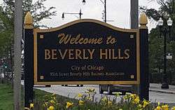
An advertisement from the Chicago Daily Tribune that appeared on May 10, 1891 extolling the advantages of living in Beverly Hills.[1]
-
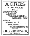
Advertisement from the Chicago Daily Tribune, November 24, 1889, advertising lots for sale in Longwood, Beverly, and the surrounding region. The area at the northern end of the ridge was first known as "the long wood", and the name of Longwood as an area of Beverly and by extension the roadway Longwood Drive perpetuates this early history.[2] The real estate firm of Samuel H. Kerfoot (1823-1896)[3] claims the distinction of being the first business to re-open in the burnt district after the Great Fire of 1871[4]
-
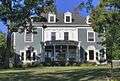
Beverly features the work of many notable architects, including Frank Lloyd Wright, George Washington Maher, Harry Waterman, Robert Seyfarth, Tallmadge and Watson and Walter Burley Griffin. This house at 10200 S. Longwood Drive was built in 1890 by Horace Horton, the owner of Chicago Bridge and Iron Company. It was designed by John G. Long, who was inspired by the H.A.C. Taylor house in Newport, Rhode Island by McKim, Mead & White (1886).[5]
- ^ "Advertisement for B.A. Ulrich & Son". Chicago Daily Tribune: 10. May 10, 1891.
- ^ Martin, William (1948). Chicago Streets. The Chicago History Museum. p. 91.
- ^ "Samuel H. Kerfoot Dead - Pioneer Real Estate Man Passes Away at his Home". The Chicago Daily Tribune: 1. December 29, 1896.
- ^ Mayer, Harold M. and Richard C. Wade (1973). Chicago: Growth of a Metropolis. Chicago: University of Chicago Press. p. 118. ISBN 0226512746.
- ^ Sinkevitch, Alice (2004). AIA Guide to Chicago - 2nd Edition. Orlando: HarcourtBooks. p. 481.
References
- ↑ Paral, Rob. "Chicago Demographics Data". Archived from the original on 2 June 2013. Retrieved 21 September 2012.
- ↑ Paral, Rob. "Chicago Census Data". Archived from the original on 5 October 2013. Retrieved 21 September 2012.
- ↑ "Advertisement for Longwood and Beverly plats by Galloway, Lyman and Patton, realtors". The Chicago Daily Tribune: 12. April 30, 1890.
- ↑ Grossman, James R., Ann Durkin Keating and Janice L. Reiff (1996). The Encyclopedia of Chicago. Chicago: The University of Chicago Press. p. 77. ISBN 0226310159.
- ↑ "Rock Island District (RI)". Retrieved 8 May 2016.
- ↑ Szucs, Loretto (1986). Chicago and Cook County sources: a genealogical and historical guide. New York: Ancestry Publishing. p. 75.
- ↑ Paral, Rob. "Chicago Community Areas Historical Data". Archived from the original on 18 March 2013. Retrieved 3 September 2012.
- ↑ Oswald, Joseph C. (2003). Chicago's Beverly/Morgan Park Neighborhood. Chicago, IL: Arcadia Publishing. p. 9.
- ↑ Foerstner, Abigail (September 2, 1987). "Where The Potawatomis Roamed Beverly, Morgan Park Evolved Around Old Indian Trail". Where The Potawatomis Roamed: Beverly, Morgan Park Evolved Around Old Indian Trail. Retrieved April 14, 2016.
- ↑ South Side Irish Parade website Archived February 11, 2010, at the Wayback Machine.
- ↑ Beverly Public Library site Archived April 27, 2010, at the Wayback Machine.
- ↑ "Chicago Sun-Times:: Search". Retrieved 8 May 2016.
- ↑ Liam Heneghan. "10 Things Wrong With Environmental Thinking". Retrieved 8 May 2016.
- Cullen, Maureen. "Boomerang Beverly." Chicago Sun-Times. July 13, 2007. S1 Front.
- Sherrod, Pamela. "12 months capture a neighborhood's history." Chicago Sun-Times. December 9, 2001. Home & Garden 3.
External links
 |
Ashburn, Chicago | |
Auburn Gresham, Chicago |
| |||
| Evergreen Park, Illinois | |
||||||
| |
Washington Heights, Chicago | ||||||
| |
|||||||
| Mount Greenwood, Chicago | Morgan Park, Chicago |