Bettendorf, Luxembourg
| Bettendorf Bettenduerf | ||
|---|---|---|
| Commune | ||
 | ||
| ||
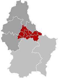
 Map of Luxembourg with Bettendorf highlighted in orange, and the canton in dark red | ||
| Coordinates: 49°53′00″N 6°13′00″E / 49.8833°N 6.2167°ECoordinates: 49°53′00″N 6°13′00″E / 49.8833°N 6.2167°E | ||
| Country |
| |
| Canton | Diekirch | |
| Government | ||
| • Mayor | Albert Back | |
| Area | ||
| • Total | 23.24 km2 (8.97 sq mi) | |
| Area rank | 40 of 105 | |
| Highest elevation | 422 m (1,385 ft) | |
| • Rank | 34th of 105 | |
| Lowest elevation | 180 m (590 ft) | |
| • Rank | 17th of 105 | |
| Population (2014) | ||
| • Total | 2,633 | |
| • Rank | 50th of 105 | |
| • Density | 110/km2 (290/sq mi) | |
| • Density rank | 57th of 105 | |
| Time zone | CET (UTC+1) | |
| • Summer (DST) | CEST (UTC+2) | |
| LAU 2 | LU00002002 | |
| Website | bettendorf.lu | |

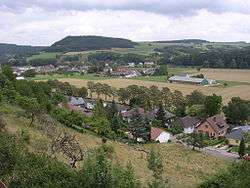
Bettendorf (Luxembourgish: Bettenduerf) is a commune and town in eastern Luxembourg. It lies along the river Sauer. It is part of the canton of Diekirch, which is part of the district of Diekirch.
As of 2001, the town of Bettendorf itself, which lies in the centre of the commune, has a population of 1,045. Other towns within the commune include Bleesbruck, Gilsdorf and Moestroff.
The privately owned Bettendorf Castle dates from 1728 and is built in the Baroque style.
External links
-
 Media related to Bettendorf, Luxembourg at Wikimedia Commons
 |
Tandel | | ||
| Diekirch | |
Reisdorf | ||
| ||||
| | ||||
| Vallée de l'Ernz |
 | ||
This article is issued from Wikipedia - version of the 12/1/2016. The text is available under the Creative Commons Attribution/Share Alike but additional terms may apply for the media files.