Betafo
For the district, see Betafo District. For the village in Arivonimamo,Itasy, see Betafo, Arivonimamo.
| Betafo | |
|---|---|
|
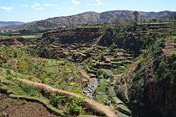
fields near Betafo | |
 Betafo Location in Madagascar | |
| Coordinates: 19°50′24″S 46°51′18″E / 19.84000°S 46.85500°ECoordinates: 19°50′24″S 46°51′18″E / 19.84000°S 46.85500°E | |
| Country |
|
| Region | Vakinankaratra |
| District | Betafo District |
| Elevation | 1,410 m (4,630 ft) |
| Population (2001)[1] | |
| • Total | 31,000 |
| Time zone | EAT (UTC3) |
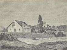
Betafo in 1885.
Betafo ("many roofs") is a town and urban commune in Vakinankaratra Region, in the Central Highlands of Madagascar. The town had an estimated population of 31,000 in 2001 [1] and is the administrative centre of Betafo District.
Geography
Betafo is situated at an altitude of 1,410 metres (4,630 ft) above sea level, in the central highlands of Madagascar. The town lies along the RN34 national road, 191 km (119 mi) from the country's capital, Antananarivo.
UNESCO World Heritage Site
The irrigated rice paddies of the area are emblematic of this technology throughout the Malagasy highlands and were nominated to the Tentative List of UNESCO World Heritage Sites in Madagascar in 1997.[2]
References
- 1 2 Cornell University. "The Commune Census of by the Ilo program of Cornell University in collaboration with FOFIFA and INSTAT".
- ↑ UNESCO. "World Heritage Convention: Madagascar". Archived from the original on April 25, 2011. Retrieved April 25, 2011.
| Wikimedia Commons has media related to Betafo. |

This article is issued from Wikipedia - version of the 10/31/2016. The text is available under the Creative Commons Attribution/Share Alike but additional terms may apply for the media files.