Bertogne
| Bertogne | |||
|---|---|---|---|
| Municipality | |||
|
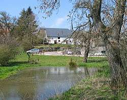
The St Lambert's church area of Bertogne | |||
| |||
 Bertogne Location in Belgium | |||
|
Location of Bertogne in Luxembourg province 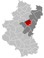 | |||
| Coordinates: 50°05′N 05°40′E / 50.083°N 5.667°ECoordinates: 50°05′N 05°40′E / 50.083°N 5.667°E | |||
| Country | Belgium | ||
| Community | French Community | ||
| Region | Wallonia | ||
| Province | Luxembourg | ||
| Arrondissement | Bastogne | ||
| Government | |||
| • Mayor | Bernard Moinet | ||
| • Governing party/ies | GC | ||
| Area | |||
| • Total | 91.67 km2 (35.39 sq mi) | ||
| Population (1 January 2016)[1] | |||
| • Total | 3,483 | ||
| • Density | 38/km2 (98/sq mi) | ||
| Postal codes | 6686-6688 | ||
| Area codes | 061 | ||
| Website | www.bertogne.be | ||

Bertogne is a Walloon municipality of Belgium located in the province of Luxembourg. On 1 January 2007 the municipality, which covers 91.67 km², had 3,002 inhabitants, giving a population density of 32.7 inhabitants per km².
The municipality consists of the following sub-municipalities: Bertogne proper, Flamierge, and Longchamps. Other population centers include:
- Bethomont
- Compogne
- Berhain
- Frenet
- Gives
- Givroulle
- Givry
- Roumont
- Salle
- Troismont
- Tronle
- Wigny
- Champs
- Fays
- Flamisoul
- Mande-Saint-Étienne
- Monaville
- Rolley
- Rouette
- Withimont
See also
References
- ↑ Population per municipality as of 1 January 2016 (XLS; 397 KB)
External links
-
 Media related to Bertogne at Wikimedia Commons
 |
Tenneville | La Roche-en-Ardenne | Houffalize | |
| Sainte-Ode | |
Bastogne | ||
| ||||
| | ||||
| Vaux-sur-Sûre |
Municipalities of Luxembourg Province | ||
|---|---|---|
| Arlon |  | |
| Bastogne | ||
| Marche-en-Famenne | ||
| Neufchâteau | ||
| Virton | ||
This article is issued from Wikipedia - version of the 12/1/2016. The text is available under the Creative Commons Attribution/Share Alike but additional terms may apply for the media files.