Bersée
| Bersée | ||
|---|---|---|
|
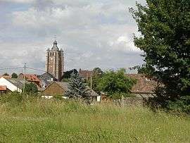
The church tower at Bersée | ||
| ||
 Bersée | ||
|
Location within Hauts-de-France region  Bersée | ||
| Coordinates: 50°28′57″N 3°08′44″E / 50.4825°N 3.1456°ECoordinates: 50°28′57″N 3°08′44″E / 50.4825°N 3.1456°E | ||
| Country | France | |
| Region | Hauts-de-France | |
| Department | Nord | |
| Arrondissement | Lille | |
| Canton | Pont-à-Marcq | |
| Intercommunality | Pays de Pévèle | |
| Government | ||
| • Mayor (2008–2014) | Henri Caudrelier | |
| Area1 | 10.93 km2 (4.22 sq mi) | |
| Population (2009)2 | 2,235 | |
| • Density | 200/km2 (530/sq mi) | |
| Time zone | CET (UTC+1) | |
| • Summer (DST) | CEST (UTC+2) | |
| INSEE/Postal code | 59071 / 59235 | |
| Elevation |
27–61 m (89–200 ft) (avg. 55 m or 180 ft) | |
|
1 French Land Register data, which excludes lakes, ponds, glaciers > 1 km² (0.386 sq mi or 247 acres) and river estuaries. 2 Population without double counting: residents of multiple communes (e.g., students and military personnel) only counted once. | ||
Bersée is a commune in the Nord department in northern France.
Population
| Historical population | ||
|---|---|---|
| Year | Pop. | ±% |
| 1793 | 1,308 | — |
| 1800 | 1,394 | +6.6% |
| 1806 | 1,459 | +4.7% |
| 1821 | 1,530 | +4.9% |
| 1831 | 1,615 | +5.6% |
| 1836 | 1,688 | +4.5% |
| 1841 | 1,744 | +3.3% |
| 1846 | 1,759 | +0.9% |
| 1851 | 1,752 | −0.4% |
| 1856 | 1,734 | −1.0% |
| 1861 | 1,755 | +1.2% |
| 1866 | 1,780 | +1.4% |
| 1872 | 1,812 | +1.8% |
| 1876 | 1,834 | +1.2% |
| 1881 | 1,843 | +0.5% |
| 1886 | 1,850 | +0.4% |
| 1891 | 1,803 | −2.5% |
| 1896 | 1,798 | −0.3% |
| 1901 | 1,808 | +0.6% |
| 1906 | 1,870 | +3.4% |
| 1911 | 1,819 | −2.7% |
| 1921 | 1,618 | −11.1% |
| 1926 | 1,573 | −2.8% |
| 1931 | 1,572 | −0.1% |
| 1936 | 1,498 | −4.7% |
| 1946 | 1,521 | +1.5% |
| 1954 | 1,561 | +2.6% |
| 1962 | 1,526 | −2.2% |
| 1968 | 1,520 | −0.4% |
| 1975 | 1,570 | +3.3% |
| 1982 | 1,806 | +15.0% |
| 1990 | 1,989 | +10.1% |
| 1999 | 2,115 | +6.3% |
| 2006 | 2,215 | +4.7% |
| 2009 | 2,235 | +0.9% |
Heraldry
 |
The arms of Bersée are blazoned : Or, a cross gules between 16 alerions azure. (the Montmorency family and the communes of Bersée and Damville use the same arms.) |
See also
References
| Wikimedia Commons has media related to Bersée. |
This article is issued from Wikipedia - version of the 9/17/2015. The text is available under the Creative Commons Attribution/Share Alike but additional terms may apply for the media files.