Berryfield

Coordinates: 51°21′36″N 2°08′49″W / 51.360°N 2.147°W
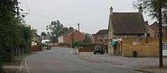
Berryfield is a small village to the south of the town of Melksham, in Wiltshire, England. The village is separated from the southwestern outskirts of Melksham by the A350 road and about 500 metres of farmland; it falls within the civil parish of Melksham Without. The Bristol Avon is about 0.6 miles (1 km) west of the village. Although very close to Melksham town, Berryfield remains a separate community.[1]
The place name came into use in the second half of the 20th century. Volume 7 of A History of the County of Wiltshire (Victoria County History, 1953) has "the district is known as Berryfields" (sic)[2] and an Ordnance Survey map published in 1958 labels only Berryfield Cottages, at the west end of the present village.[3] Development began in World War II when houses were built as accommodation for an RAF training school at Bowerhill, about 0.6 miles (1 km) to the east.[4] This development was accessed from the A350 road towards Semington and Trowbridge; in 2004 Berryfield was bypassed by a new section of the A350, taking through traffic away from the village. [5]
The Wilts & Berks Canal, opened in 1810 and abandoned in 1914, passed east of Berryfield on its way from its junction with the Kennet and Avon Canal to the east side of Melksham. The Wilts & Berks is under restoration but its original route in this area is no longer available, so in 2012 a planning application was submitted for a new section of canal (called the Melksham Link) which will pass through Berryfield.[6]
About one thousand people live in Berryfield. There is a pub called the New Inn on the former A350, and there is also a playground. The village shop closed but has reopened as a pram and baby shop, and there is a café next door.[7]
References
- ↑ "Melksham Without". Wiltshire Community History. Wiltshire County Council. Retrieved 4 September 2016.
- ↑ "Victoria County History - Wiltshire - Vol 7 pp99-121 - Parishes: Melksham". British History Online. University of London. Retrieved 28 December 2015.
- ↑ "Ordnance Survey 1:25,000 maps of Great Britain, sheet ST86". National Library of Scotland. Retrieved 28 December 2015.
- ↑ "Berryfield". Melksham Without Parish Council. Retrieved 28 December 2015.
- ↑ "Bypass set to open to fanfare of celebrations". Brighton. 26 March 2004. Retrieved 28 December 2015.
- ↑ "Plans for Wiltshire town's canal submitted". BBC News - Wiltshire. 12 July 2012. Retrieved 28 December 2015.
- ↑ "Berryfield". Melksham Without Parish Council. Retrieved 4 September 2016.
External links
- "Melksham Without". Wiltshire Community History. Wiltshire Council. Retrieved 28 December 2015.
![]() Media related to Berryfield at Wikimedia Commons
Media related to Berryfield at Wikimedia Commons