Berounka
| Berounka | |
| Mže | |
| River | |
 The Berounka under Tetín | |
| Country | Czech Republic |
|---|---|
| Cities | Tachov, Stříbro, Plzeň, Beroun, Prague |
| Primary source | Mže |
| - location | Griesbacher Wald, Germany |
| - elevation | 726 m (2,382 ft) |
| - length | 106.5 m (349.4 ft) |
| - coordinates | 49°51′10″N 12°28′00″E / 49.85278°N 12.46667°E |
| Secondary source | Radbuza |
| - elevation | 869 m (2,851 ft) |
| - length | 112 m (367.5 ft) |
| - coordinates | 49°29′13″N 12°39′58″E / 49.48694°N 12.66611°E |
| Source confluence | Pilsen |
| Mouth | Vltava |
| - location | Prague |
| - coordinates | 49°59′43″N 14°24′05″E / 49.99528°N 14.40139°ECoordinates: 49°59′43″N 14°24′05″E / 49.99528°N 14.40139°E |
| Length | 139.1 km (86.4 mi) |
| Discharge | mouth |
| - average | 36 m3/s (1,271 cu ft/s) |
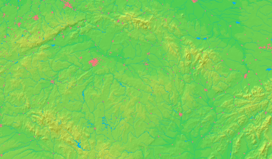 _-_location_map.svg.png) The Berounka with its two sources the Mže (northern) and the Radbuza (southern) until its confluence with the Vltava (magenta), also showing its watershed
| |
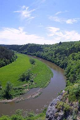
The Berounka under Krašov Castle
The Berounka is a river in the Czech Republic, the biggest left tributary of Vltava. It carries the name Mže (German: Mies) from its source in Germany, next to the Czech border, until its confluence with the Radbuza in Pilsen. It then continues under the name of Berounka until it enters the Vltava on the edge of Prague. Originally, the entire stream was called Mže, but in the 17th century the lower course started to be named after the town Beroun, lying upon it.
The river is a favourite destination among canoeists, who enjoy the picturesque sceneries around, especially when it flows along the Křivoklátsko Landscape Protected Area where three castle ruins tower over the Berounka river valley.
This article is issued from Wikipedia - version of the 3/21/2016. The text is available under the Creative Commons Attribution/Share Alike but additional terms may apply for the media files.