Bernier Island
 | |
| Geography | |
|---|---|
| Location | Shark Bay |
| Administration | |
|
Australia | |
| State | Western Australia |
| Region | Gascoyne |
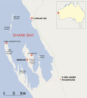
Bernier Island is one of three islands that comprise the Bernier and Dorre Island Nature Reserve in the Shark Bay World Heritage area in Western Australia.[1]
It was a hospital location in the early 1900s.[2][3]
It is located at the north-western corner of the World Heritage area, almost due west of Carnarvon, Western Australia. The 2.6 hectares (6 acres) Koks Island is offshore from the lighthouse at its northern end. It is separated from Dorre Island to its south by a 500 metres (1,640 ft) gap with a depth of 4 m (13 ft).
The island is home to one of the few remaining colonies of the Banded Hare-wallaby (Lagostrophus fasciatus)[4] and the endangered Shark Bay mouse of which there is an estimated 5,000 to 9,000 individuals.[5]
See also
References
- ↑ Hancock, Sue; Brown, Paul; and Stephens, Burke. (2000). Shark Bay Terrestrial Reserves Management Plan 2000-2009. Department of Conservation and Land Management, for the National Parks and Nature Conservation Authority, Perth, Western Australia. ISBN 0-7307-5510-X
- ↑ Hunter, Ernest M. (1993). Aboriginal health and history: power and prejudice in remote Australia. Cambridge [England]; Melbourne: Cambridge University Press. ISBN 0-521-44760-7 (History of treating venereal diseases among aborigines in the Kimberley, removal to Dorre and Bernier Islands). Aboriginal health and history, p.58-61.
- ↑ Jebb, Mary Anne. (1984). The Lock hospitals experiment: Europeans, aborigines and venereal disease. Studies in Western Australian History, No.8 (Dec. 1984), p.68-87.
- ↑ Groves, C.P. (2005). Wilson, D.E.; Reeder, D.M., eds. Mammal Species of the World: A Taxonomic and Geographic Reference (3rd ed.). Baltimore: Johns Hopkins University Press. p. 59. OCLC 62265494. ISBN 0-801-88221-4.
- ↑ "The Action Plan for Australian Rodents". Department of the Environment. 1 April 1995. Retrieved 24 December 2015.
Coordinates: 24°52′S 113°10′E / 24.867°S 113.167°E