Berlin Mountain
| Berlin Mountain | |
|---|---|
| Highest point | |
| Elevation | 2,818 ft (859 m) |
| Coordinates | 42°41′32″N 73°17′08″W / 42.69222°N 73.28556°WCoordinates: 42°41′32″N 73°17′08″W / 42.69222°N 73.28556°W |
| Geography | |
| Location | Berlin, New York and Williamstown, Massachusetts |
| Parent range | Taconic Mountains |
| Geology | |
| Age of rock | Ordovician |
| Mountain type | Thrust fault; metamorphic rock and sedimentary rock |
| Climbing | |
| Easiest route | '09 Trail |
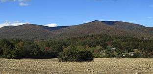
Berlin Mountain, 2,818 feet (859 m), is a prominent peak in the Taconic Mountains of western New England and is located adjacent to Massachusetts's border with New York State. It is the highest point in Rensselaer County, and the highest mountain in New York outside of the Adirondacks and Catskills.The summit and west side of the mountain are located in New York; the east side lies within, Williamstown Massachusetts. The mountain is a bald, notable for its grassy summit and expansive views of the Hudson River Valley to the west. The 35 mi (56 km) Taconic Crest Trail traverses the mountain. Several other hiking trails approach the summit from the east. Much of the upper slopes and summit are within protected conservation land.
Historically the lower slopes of the mountain were farmed heavily throughout the 19th Century. In addition to agriculture, there are several remants of charcoal kilns located on the mountain that produced fuel for iron smelting .[1]
References
- ↑ Origins of Williammstown by Arthur L. Perry, Charles Scriber's Sons 1894
External links
- Berkshire Natural Resource Council.
- Rensselaer Land Trust.
- Hopkins Memorial Forest map.
- Hopkins Memorial Forest history
- Taconic Hiking Club
- Williamstown Rural Lands Foundation
- Williamstown Rural Lands Foundation trail map