Berlin-Spandau Ship Canal
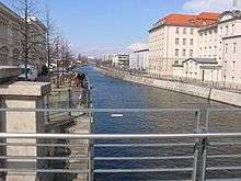
Coordinates: 52°32′12″N 13°21′49″E / 52.5366°N 13.3637°E The Berlin-Spandau Ship Canal, or Berlin-Spandauer Schifffahrtskanal in German, is a canal in Berlin, Germany. It was built between 1848 and 1859 to a plan created by Peter Joseph Lenné, and was formerly known as the Hohenzollern Canal or Hohenzollernkanal.
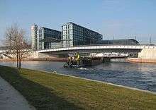
The 12.2-kilometre (7.6 mi) long canal links the River Havel north of Spandau to the River Spree near the Hauptbahnhof in Berlin. Because it joins the River Havel upstream of the river lock at Spandau, it provides a more direct route from the River Spree to the Oder–Havel Canal.[1]
The Westhafen, Berlin's largest port with an area of 173,000 m² (42.75 acres), lies on the Berlin-Spandau Ship Canal some 4 kilometres (2.5 mi) from its eastern (River Spree) end. The Westhafen Canal and Charlottenburg Canal also connect the port to the River Spree further downstream in Charlottenburg.[1]
References
| Wikimedia Commons has media related to Berlin-Spandauer Schifffahrtskanal. |