Berlin/Brandenburg Metropolitan Region
| Berlin/Brandenburg Metropolitan Region Metropolregion Berlin/Brandenburg | |
|---|---|
|
Berlin agglomeration City of Berlin Berlin city centre | |
| Country |
|
| States |
|
| Largest city | Berlin (3,610,156 inh. in 2015)[1] |
| Area | |
| • Metro | 30,370 km2 (11,730 sq mi) |
| Population (2015) | |
| • Metro | 6,004,857 |
| • Metro density | 193/km2 (500/sq mi) |
| Time zone | CET (UTC+1) |
| Website | Official website |
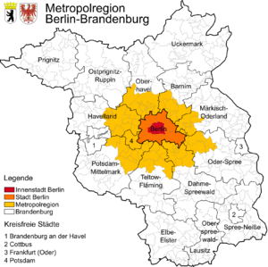
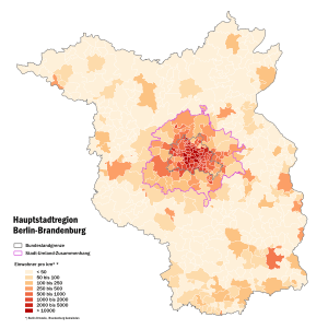
The Berlin/Brandenburg Metropolitan Region (German: Metropolregion Berlin/Brandenburg, also Hauptstadtregion Berlin-Brandenburg) is one of eleven metropolitan regions of Germany, consisiting of the entire territories of the city-state of Berlin and the surrounding state of Brandenburg. The region covers an area of 30,370 square kilometres (11,730 sq mi) with a total population exceeding 6 million.[2][3]
The metropolitan region has to be distinguished from the Berlin agglomeration comprising the city and the surrounding Brandenburg municipalities (Berliner Umland).
Geography
Beside the city of Berlin, the metropolitan region covers five independent cities – of which the Brandenburg capital Potsdam is the only one with a population greater than 100,000 – and 14 districts (Landkreise). The inhabitants of Berlin and Potsdam account for more than 80 percent of the region's total population. The Brandenburg area is characterized by suburban settlements on the Berlin city limits and small towns in the rural outer area.
The Berlin agglomeration counts the cities of Berlin, Potsdam, and 67 other municipalities.[4] These other communes are listed below, subdivided per district. The municipalities marked with (c) have city status:
- Barnim: Ahrensfelde, Bernau(c), Panketal, Rüdnitz, Wandlitz, Werneuchen(c).
- Dahme-Spreewald: Bestensee, Eichwalde, Heidesee, Königs Wusterhausen(c), Mittenwalde(c), Schönefeld, Schulzendorf, Wildau, Zeuthen.
- Havelland: Brieselang, Dallgow-Döberitz, Falkensee(c), Ketzin(c), Nauen(c), Paulinenaue, Pessin, Retzow, Schönwalde-Glien, Wustermark.
- Märkisch-Oderland: Altlandsberg(c), Fredersdorf-Vogelsdorf, Hoppegarten, Neuenhagen, Petershagen-Eggersdorf, Rüdersdorf, Strausberg(c).
- Oberhavel: Birkenwerder, Glienicke/Nordbahn, Hennigsdorf(c), Hohen Neuendorf(c), Kremmen(c), Leegebruch, Mühlenbecker Land, Oranienburg(c), Velten.
- Oder-Spree: Erkner(c), Fürstenwalde(c), Gosen-Neu Zittau, Grünheide, Langewahl, Rauen, Schöneiche, Spreenhagen, Woltersdorf
- Potsdam-Mittelmark: Beelitz(c), Borkheide, Groß Kreutz, Kleinmachnow, Michendorf, Nuthetal, Schwielowsee, Seddiner See, Stahnsdorf, Teltow(c), Werder(c).
- Teltow-Fläming: Blankenfelde-Mahlow, Großbeeren, Ludwigsfelde(c), Rangsdorf, Trebbin(c), Zossen(c).
Centralities
The metropolitan region counts three levels of centralities (Zentralörtliche Gliederung): The metropolis (Metropole) of Berlin, the four upper level regional centres (Oberzentren) of Potsdam, Cottbus, Brandenburg an der Havel and Frankfurt (Oder), as well as 42 secondary centres (Mittelzentren) allocated to 50 towns.
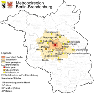
The Berlin agglomeration comprises the metropolis Berlin, the regional centre of Potsdam and 17 secondary centres:
- Bernau
- Strausberg
- Fürstenwalde
- Königs Wusterhausen
- Ludwigsfelde
- Nauen
- Oranienburg
- Erkner
- Neuenhagen
- Zossen
- Teltow
- Falkensee
- Hennigsdorf
- Wildau and Schönefeld
- Werder and Beelitz
-
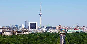
Berlin is the capital of Germany, its biggest city and the second most populous city proper in the European Union
-
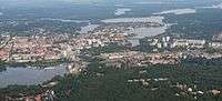
Aerial view over Potsdam, capital of Brandenburg
Demographics
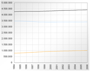
Population of the Berlin agglomeration is close to 4¼ million (out of 6 million for all of the metropolitan region), mainly condensed in Berlin and Potsdam. The other towns have a population lesser than 50,000 inhabitants and the lesser-populated municipalities are Pessin (654) and Retzow (562). The list shows the most populated places in the Berlin agglomeration area:
- Berlin (3,517,424)
- Potsdam (161,468)
- Oranienburg (41,966)
- Falkensee (40,900)
- Bernau (36,624)
- Königs Wusterhausen (34,083)
- Fürstenwalde (32,456)
- Strausberg (26,156)
- Hennigsdorf (25,988)
- Blankenfelde-Mahlow (25,934)
- Hohen Neuendorf (24,551)
- Ludwigsfelde (24,150)
- Werder (23,211)
- Teltow (23,069)
- Wandlitz (21,801)
- Kleinmachnow (20,181)
- Panketal (19,291)
- Zossen (17,717)
- Neuenhagen (16,972)
- Hoppegarten (16,808)
- Nauen (16,804)
- Rüdersdorf (15,317)
See also
Notes and references
- ↑ "Bevölkerungsstand in Berlin am 31. Dezember 2013 nach Bezirken". Amt für Statistik Berlin-Brandenburg (in German). 18 February 2014. Retrieved 20 August 2014.
- ↑ (German) Hauptstadtregion Berlin-Brandenburg
- ↑ (German) Daten und Fakten zur Hauptstadtregion Archived October 29, 2012, at the Wayback Machine.
- ↑ (German) Geographic portal on the official website
- ↑ (German) Population statistics of Berlin and Brandenburg
External links
- (German) Metropolregion Berlin/Brandenburg (official site)
| Administration |
| |
|---|---|---|
| Society | ||
| Other topics | ||
| ||