Benton City – Kiona Bridge
| Benton City – Kiona Bridge | |
|---|---|
 Looking up at the bridge from the banks of the Yakima River | |
| Coordinates | 46°15′10.54″N 119°28′31.74″W / 46.2529278°N 119.4754833°WCoordinates: 46°15′10.54″N 119°28′31.74″W / 46.2529278°N 119.4754833°W |
| Carries |
|
| Crosses | Yakima River |
| Locale | Benton City, Washington |
| Maintained by | WSDOT |
| ID number | 082446000000000 |
| Characteristics | |
| Design | box girder bridge/cable-stayed bridge |
| Material | steel |
| Total length | 400 feet (121.9 m) |
| Width | 26 feet (7.8 m) |
| History | |
| Designer | Homer M. Hadley |
| Opened | July 4, 1957 |
| Statistics | |
| Daily traffic | 9,500 (2012) |
| References | |
| [1][2] | |
The Benton City – Kiona Bridge is a steel box girder and cable-stayed bridge carrying two lanes of Washington State Route 225 over the Yakima River in Benton City, Benton County, Washington. The current span was opened to traffic on July 4, 1957 and measures 400-foot-long (121.9 m) by 26-foot (7.8 m) wide. Two bridges had previously connected the cities of Benton City and Kiona before and were located 300 feet (91 m) downstream. The first bridge was open by 1901, and the immediate predecessor bridge was closed and torn down in 1964. The bridge is owned and maintained by the Washington State Department of Transportation, and was added to the Washington Heritage Register on January 25, 2002.
Description
The Benton City – Kiona Bridge is located about 150 feet (46 m) from the southern terminus of Washington State Route 225 (SR 225) in Benton City,[3] just south of downtown. The unincorporated community of Kiona is just south of concurrent highways Interstate 82 (I-82) / U.S. Route 12 (US 12), where SR 225 terminates.[4] The bridge is 400-foot-long (121.9 m) by 26-foot (7.8 m) wide,[1] carrying two lanes of SR 225, linking Benton City to I-82/US 12. While SR 225 on both sides of the bridge features bicycle lanes, the bridge does not.[3] The bridge does feature 4-foot-wide (1.2 m) sidewalks raised 10 inches (25 cm) above the roadway surface.[5]
The bridge, as well as the remainder of SR 225 are considered a major collector road by the Washington State Department of Transportation (WSDOT),[6] which the Federal Highway Administration defines as linking towns to larger arterials.[7] Every year, WSDOT conducts a series of surveys on its highways in the state to measure traffic volume. This is expressed in terms of average annual daily traffic (AADT), a measure of traffic volume for any average day of the year. In 2012, WSDOT calculated that 9,500 vehicles traveled on SR-225 along the bridge.[2]
History
Earlier spans
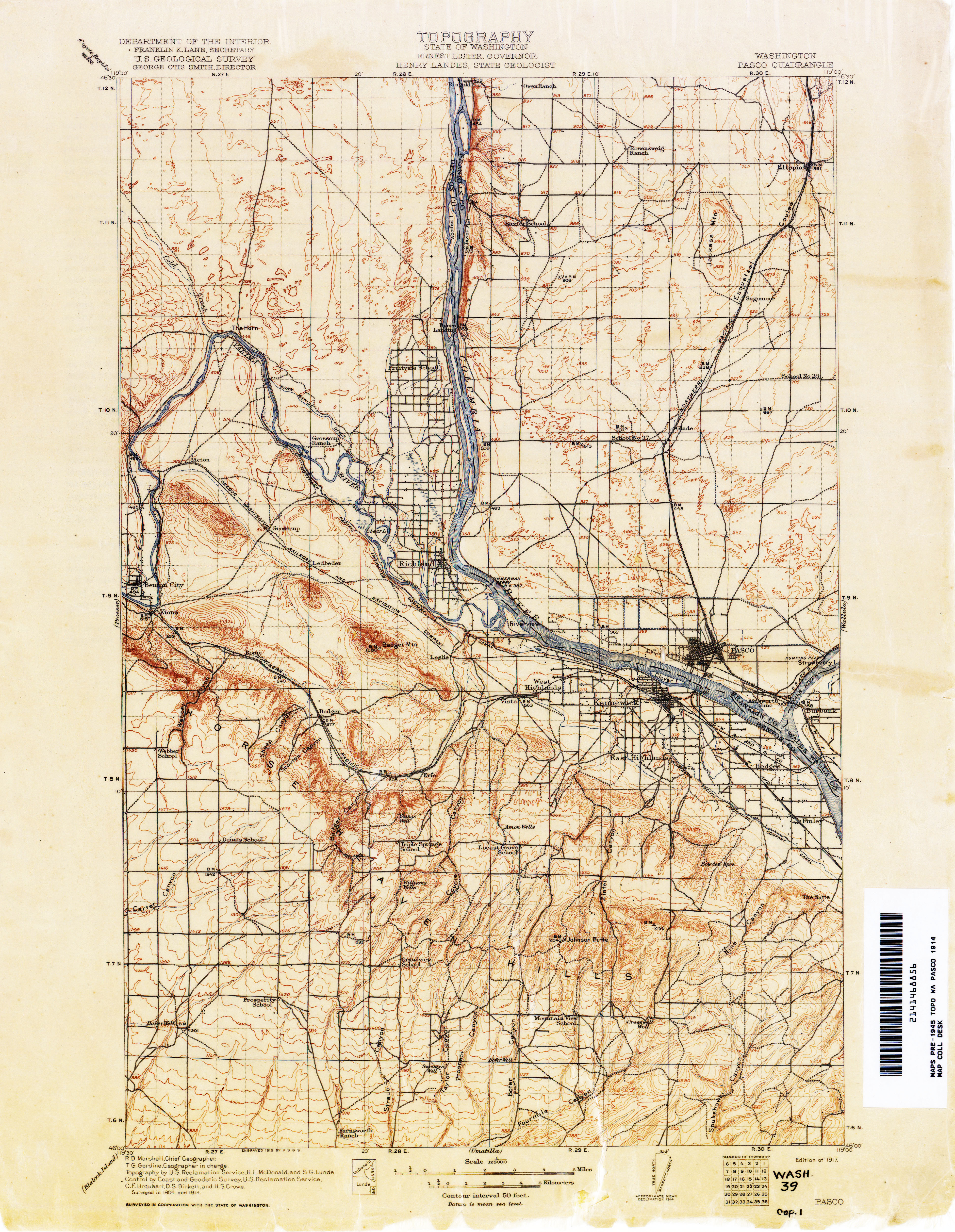
The first span recorded was built by 1901. That bridge was destroyed during a flood along the Yakima River in late 1917.[8] This bridge was recorded on the Pasco quadrangle produced by the United States Geological Survey in 1914.[9] The letters "US" were inscribed in one of the approach spans of the bridge as a way marker for travelers through the region.[10] Major flooding happened along the Yakima River near Benton City in 1894, 1917, 1922, 1933, and 1948.[11] A new bridge was built after the original span collapsed in the flood. By 1954 the second bridge was considered no longer sufficient for the traveling public with a roadway less than 17 feet (5.2 m) wide.[12] The second bridge was torn down in 1964, seven years after the opening of the current bridge.[13]

Current span
The first proposals for the current bridge were submitted in November 1955, with a cost estimate of $140 thousand (equivalent to $3 million in 2015).[14] The bridge was designed so that there was a clearance of 2 feet 9 inches (0.84 m) higher than the 1933 Yakima River flood level.[5][15] The new bridge was to be built 600 feet (180 m) downstream from the previous bridge,[16] but was built 300 feet (91 m) upstream instead.[17] The second bridge had been in place for 40 years and was seeing an average of 1,700 cars-per-day over the bridge.[16] By comparison 9,500 cars on an average 2012 day travel over the current bridge.[2]
Everett McKellar of Chelan won the contract to build the bridge, designed by Homer M. Hadley in 1956.[18] Hadley designed the Lacey V. Murrow Memorial Bridge across Lake Washington and the Third Lake Washington Bridge was named after him.[19] The cost of the bridge came out at just over $196 thousand (equivalent to $4.1 million in 2015),[14][20] and was opened to traffic on July 4, 1957.[5][21]
The bridge is believed to be the first steel box girder bridge built in the United States,[5] and is considered a prototype of the cable-stayed bridge of which a very similar design by the Germans was completed, the Stroemsund Bridge in Sweden. Similar bridges include a timber-stayed bridge designed in Germany in 1784, the wrought-iron stayed Albert Bridge in London designed in 1873, and the Chow Chow Bridge in Grays Harbor County.[22] The bridge was listed on the Washington Heritage Register on January 25, 2002.[23]
See also
 Bridges portal
 Washington Roads portal
References
- 1 2 Federal Highway Administration (2012). "NBI Structure Number: 082446000000000". National Bridge Inventory. Federal Highway Administration.
- 1 2 3 Staff. 2012 Annual Traffic Report (PDF) (Report). WSDOT. p. 158. Retrieved January 21, 2014.
- 1 2 "State Highway Log Planning Report 2012: SR 2 to SR 971" (PDF). Washington State Department of Transportation (WSDOT). p. 1152. Retrieved January 21, 2014.
- ↑ Google (January 21, 2014). "Benton City – Kiona Bridge" (Map). Google Maps. Google. Retrieved January 21, 2014.
- 1 2 3 4 Hadley, Homer (January 1958). "Tied-Cantilever Bridge—Pioneer Structure in U.S.". Civil Engineering. Reston, Virginia: American Society of Civil Engineers: 48–50. ISSN 0885-7024. OCLC 10480594.
- ↑ WSDOT Functional Classification Map (Map). Washington State Department of Transportation. January 21, 2014.
- ↑ Highway Functional Classification Concepts, Criteria and Procedures (PDF). Federal Highway Administration. 2013. p. 17. Retrieved December 17, 2013.
- ↑ "Kiona Bridge, River Frozen Over. Marjorie Standing on Ice". Washington Rural Heritage. January 1909. Retrieved January 22, 2014.
- ↑ Pasco Quadrangle (Map). 1:125,000. Cartography by USGS. United States Geological Survey. 1917. Retrieved January 22, 2014.
- ↑ Marshall, Robert Bradford (1918). Spirit Leveling in New York, 1896–1905 and 1912–1916. U.S. Government Printing Office. p. 111. OCLC 5759973. Retrieved January 22, 2014.
- ↑ Community Development Program (1959). History of Benton City Washington, 1853–1959. p. 9. OCLC 18320586. Retrieved January 22, 2014.
- ↑ Staff (1954). Better Roads. 24. A. Perrin. p. 28. OCLC 1519687. Retrieved January 22, 2014.
- ↑ Dunlap, Robert J (1964). "Old Bridge torn down". Washington Rural Heritage. Retrieved January 22, 2014.
- 1 2 United States nominal Gross Domestic Product per capita figures follow the Measuring Worth series supplied in Johnston, Louis; Williamson, Samuel H. (2016). "What Was the U.S. GDP Then?". MeasuringWorth. Retrieved April 10, 2016. These figures follow the figures as of 2015.
- ↑ Staff (November 18, 1955). "Surveys of Span Sent Consultant". Spokane Daily Chronicle. p. 3. OCLC 14374699.
- 1 2 Staff (June 28, 1956). "Benton City Bridge Design Okayed". Tri-City Herald. OCLC 43628599.
- ↑ Staff (July 4, 1957). "New Benton City Bridge Almost Ready". The Spokesman-Review. Spokane, Washington. p. 6. OCLC 11102610. Retrieved January 22, 2014.
- ↑ Soderberg, Lisa (1979). "Keiona - Benton City Bridge" (PDF). OAHP Inventory. Department of Archaeology & Historic Preservation. Archived from the original (PDF) on February 2, 2014. Retrieved January 21, 2014.
- ↑ Chen, Wai-Fah; Duan, Lian (October 11, 2013). Handbook of International Bridge Engineering. CRC Press. pp. 109–10. ISBN 978-1-4398-1029-3. Retrieved January 22, 2014.
- ↑ "Contract for Span Awarded". Tri-City Herald. September 7, 1956. OCLC 43628599.
- ↑ Staff (Nov 13, 2007). "Tri-City Herald timeline 1947–2006". Tri-City Herald. p. T0. OCLC 43628599.
- ↑ Holstine, Craig E.; Hobbs, Richard (2005). Spanning Washington: Historic Highway Bridges of the Evergreen State. Pullman, Washington: WSU Press. pp. 141–2. ISBN 0-87422-281-8. OCLC 58043209.
- ↑ Staff. "Benton City-Kiona Bridge" (PDF). Historic Register Report. Washington State Department of Archaeology & Historic Preservation. Retrieved January 21, 2014.
External links
 Media related to Benton City - Kiona Bridge at Wikimedia Commons
- OAHP inventory form
- Benton City Bridge at Structurae