Bentleyville, Ohio
| Bentleyville, Ohio | |
|---|---|
| Village | |
|
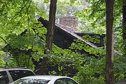
Look About Lodge, South Chagrin Reservation | |
| Motto: "Serve, Preserve, Conserve" | |
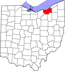
 Location in Cuyahoga County and the state of Ohio. | |
.svg.png) Location of Ohio in the United States | |
| Coordinates: 41°24′49″N 81°24′47″W / 41.41361°N 81.41306°WCoordinates: 41°24′49″N 81°24′47″W / 41.41361°N 81.41306°W | |
| Country | United States |
| State | Ohio |
| County | Cuyahoga |
| Government | |
| • Mayor | Leonard A. Spremulli |
| Area[1] | |
| • Total | 2.60 sq mi (6.73 km2) |
| • Land | 2.56 sq mi (6.63 km2) |
| • Water | 0.04 sq mi (0.10 km2) |
| Elevation[2] | 935 ft (285 m) |
| Population (2010)[3] | |
| • Total | 864 |
| • Estimate (2012[4]) | 863 |
| • Density | 337.5/sq mi (130.3/km2) |
| Time zone | Eastern (EST) (UTC-5) |
| • Summer (DST) | EDT (UTC-4) |
| ZIP code | 44022 |
| Area code(s) | 440 |
| FIPS code | 39-05550[5] |
| GNIS feature ID | 1037862[2] |
| Website | villageofbentleyville.com |
Bentleyville is a village in Cuyahoga County, Ohio, United States. The population was 864 at the 2010 census.[6]
Bentleyville was laid out in 1831 by Adamson Bentley, and named for him.[7]
Geography
Bentleyville is located at 41°24′49″N 81°24′47″W / 41.41361°N 81.41306°W (41.413520, -81.412996).[8]
According to the United States Census Bureau, the village has a total area of 2.60 square miles (6.73 km2), of which 2.56 square miles (6.63 km2) is land and 0.04 square miles (0.10 km2) is water.[1]
Government
The current mayor of Bentleyville is Leonard Spremulli.[9] He has been in office since January, 2008. There are currently six members on village council.[10] The mayor and council members are elected every four years.
Demographics
| Historical population | |||
|---|---|---|---|
| Census | Pop. | %± | |
| 1930 | 83 | — | |
| 1940 | 117 | 41.0% | |
| 1950 | 152 | 29.9% | |
| 1960 | 301 | 98.0% | |
| 1970 | 338 | 12.3% | |
| 1980 | 381 | 12.7% | |
| 1990 | 674 | 76.9% | |
| 2000 | 947 | 40.5% | |
| 2010 | 864 | −8.8% | |
| Est. 2015 | 857 | [11] | −0.8% |
2010 census
As of the census[3] of 2010, there were 864 people, 303 households, and 261 families residing in the village. The population density was 337.5 inhabitants per square mile (130.3/km2). There were 318 housing units at an average density of 124.2 per square mile (48.0/km2). The racial makeup of the village was 95.0% White, 0.7% African American, 2.8% Asian, and 1.5% from two or more races. Hispanic or Latino of any race were 0.6% of the population.
There were 303 households of which 44.6% had children under the age of 18 living with them, 81.2% were married couples living together, 3.3% had a female householder with no husband present, 1.7% had a male householder with no wife present, and 13.9% were non-families. 13.2% of all households were made up of individuals and 4.6% had someone living alone who was 65 years of age or older. The average household size was 2.85 and the average family size was 3.14.
The median age in the village was 46.2 years. 29.3% of residents were under the age of 18; 5.2% were between the ages of 18 and 24; 13.2% were from 25 to 44; 42.3% were from 45 to 64; and 10.1% were 65 years of age or older. The gender makeup of the village was 49.5% male and 50.5% female.
2000 census
As of the census[5] of 2000, there were 947 people, 297 households, and 263 families residing in the village. The population density was 363.3 people per square mile (140.1/km²). There were 306 housing units at an average density of 117.4 per square mile (45.3/km²). The racial makeup of the village was 97.15% White, 0.84% African American, 1.80% Asian, and 0.21% from two or more races. Hispanic or Latino of any race were 0.95% of the population.
There were 297 households out of which 52.9% had children under the age of 18 living with them, 85.9% were married couples living together, 2.4% had a female householder with no husband present, and 11.4% were non-families. 8.8% of all households were made up of individuals and 2.4% had someone living alone who was 65 years of age or older. The average household size was 3.19 and the average family size was 3.43.
In the village the population was spread out with 36.4% under the age of 18, 3.2% from 18 to 24, 21.5% from 25 to 44, 32.7% from 45 to 64, and 6.1% who were 65 years of age or older. The median age was 41 years. For every 100 females there were 103.7 males. For every 100 females age 18 and over, there were 99.3 males.
The median income for a household in the village was $160,902, and the median income for a family was $183,243. Males had a median income of $100,000 versus $55,313 for females. The per capita income for the village was $72,392. None of the families and 1.0% of the population were living below the poverty line, including no under eighteens and 1.7% of those over 64.
Education
Bentleyville is served by the Chagrin Falls Exempted Village School District.
References
- 1 2 "US Gazetteer files 2010". United States Census Bureau. Archived from the original on 2012-07-14. Retrieved 2013-01-06.
- 1 2 "US Board on Geographic Names". United States Geological Survey. 2007-10-25. Retrieved 2008-01-31.
- 1 2 "American FactFinder". United States Census Bureau. Retrieved 2013-01-06.
- ↑ "Population Estimates". United States Census Bureau. Archived from the original on 2013-06-17. Retrieved 2013-06-17.
- 1 2 "American FactFinder". United States Census Bureau. Archived from the original on 2013-09-11. Retrieved 2008-01-31.
- ↑ "Profile of General Population and Housing Characteristics: 2010 Demographic Profile Data (DP-1): Bentleyville village, Ohio". U.S. Census Bureau, American Factfinder. Archived from the original on September 11, 2013. Retrieved November 22, 2011.
- ↑ Overman, William Daniel (1958). Ohio Town Names. Akron, OH: Atlantic Press. p. 12.
- ↑ "US Gazetteer files: 2010, 2000, and 1990". United States Census Bureau. 2011-02-12. Retrieved 2011-04-23.
- ↑ http://www.villageofbentleyville.org/index.php?section=25
- ↑ http://www.villageofbentleyville.com/council-and-committees
- ↑ "Annual Estimates of the Resident Population for Incorporated Places: April 1, 2010 to July 1, 2015". Retrieved July 2, 2016.
- ↑ "Census of Population and Housing". Census.gov. Archived from the original on May 11, 2015. Retrieved June 4, 2015.
External links
Municipalities and communities of Cuyahoga County, Ohio, United States | ||
|---|---|---|
| Cities |
|  |
| Villages | ||
| Townships | ||
| Footnotes | ‡This populated place also has portions in an adjacent county or counties | |